Quantcast
Channel: Cambodia E-Visa Blog
Viewing all 104 articles
Browse latest View live

Choeung Ek Museum

$
0
0
Choeung Ek (Khmer: ជើងឯក [cəəŋ aek]), the site of a former orchard and mass grave of victims of the Khmer Rouge - killed between 1975 and 1979 - about 17 km south of Phnom Penh, Cambodia, is the best-known of the sites known as The Killing Fields, where theKhmer Rouge regime executed over one million people between 1975 and 1979. Mass graves containing 8,895 bodies were discovered at Choeung Ek after the fall of the Khmer Rouge regime. Many of the dead were former political prisoners who were kept by the Khmer Rouge in their Tuol Sleng detention center.​​​​​​​​​​​​​​​​​​​​
Buddhist Stupa at Choeung Ek killing fields

Today, Choeung Ek is a memorial, marked by a Buddhist stupa. The stupa has acrylic glass sides and is filled with more than 5,000 human skulls. Some of the lower levels are opened during the day so that the skulls can be seen directly. Many have been shattered or smashed in.
Tourists are encouraged by the Cambodian government to visit Choeung Ek. Apart from the stupa, there are pits from which the bodies were exhumed. Human bones still litter the site. On May 3, 2005, the Municipality of Phnom Penh announced that they had entered into a 30-year agreement with JC Royal Co. to develop the memorial at Choeung Ek. As part of the agreement, they are not to disturb the remains still present in the field. The film The Killing Fields is a dramatized portrayal of events like those that took place at Choeung Ek.

choeung ek mass graves


Quoted from: http://en.wikipedia.org/wiki/Choeung_Ek


Cambodian History

$
0
0
No one knows for certain how long people have lived in what is now Cambodia, as studies of its prehistory are undeveloped. A carbon-l4 dating from a cave in northwestern Cambodia suggests that people using stone tools lived in the cave as early as 4000 bc, and rice has been grown on Cambodian soil since well before the 1st century ad. The first Cambodians likely arrived long before either of these dates. They probably migrated from the north, although nothing is known about their language or their way of life.
By the beginning of the 1st century ad, Chinese traders began to report the existence of inland and coastal kingdoms in Cambodia. These kingdoms already owed much to Indian culture, which provided alphabets, art forms, architectural styles, religions (Hinduism and Buddhism), and a stratified class system. Local beliefs that stressed the importance of ancestral spirits coexisted with the Indian religions and remain powerful today.
Cambodia's modem-day culture has its roots in the 1st to 6th centuries in a state referred to as Funan, known as the oldest Indianized state in Southeast Asia. It is from this period that evolved Cambodia's language, part of the Mon-Khmer family, which contains elements of Sanskrit, its ancient religion of Hinduism and Buddhism. Historians have noted, for example, that Cambodians can be distinguished from their neighbors by their clothing - checkered scarves known as Kramas are worn instead of straw hats.
Funan gave way to the Angkor Empire with the rise to power of King Jayavarman II in 802. The following 600 years saw powerful Khmer kings dominate much of present day Southeast Asia, from the borders of Myanmar east to the South China Sea and north to Laos. It was during this period that Khmer kings built the most extensive concentration of religious temples in the world - the Angkor temple complex. The most successful of Angkor's kings, Jayavarman II, Indravarman I, Suryavarman II and Jayavarman VII, also devised a masterpiece of ancient engineering: a sophisticated irrigation system that includes barays (gigantic man-made lakes) and canals that ensured as many as three rice crops a year. Part of this system is still in use today.

The Khmer Kingdom (Funan)

Early Chinese writers referred to a kingdom in Cambodia that they called Funan. Modern-day archaeological findings provide evidence of a commercial society centered on the Mekong Delta that flourished from the 1st century to the 6th century. Among these findings are excavations of a port city from the 1st century, located in the region of Oc-Eo in what is now southern Vietnam. Served by a network of canals, the city was an important trade link between India and China. Ongoing excavations in southern Cambodia have revealed the existence of another important city near the present-day village of Angkor Borei.
A group of inland kingdoms, known collectively to the Chinese as Zhenla, flourished in the 6th and 7th centuries from southern Cambodia to southern Laos. The first stone inscriptions in the Khmer language and the first brick and stone Hindu temples in Cambodia date from the Zhenla period.

Angkor Era

Bayon Temple, Angkor Thom The giant faces carved on the Bayon temple at the Angkor Thum complex in northwestern Cambodia represent both the Buddha and King Jayavarman VII (ruled about 1130-1219). Although a Buddhist temple, Angkor Thum was modeled after the great Hindu temple complex of Angkor Wat.
In the early 9th century a Khmer (ethnic Cambodian) prince returned to Cambodia from abroad. He probably arrived from nearby Java or Sumatra, where he may have been held hostage by island kings who had asserted control over portions of the Southeast Asian mainland.
In a series of ceremonies at different sites, the prince declared himself ruler of a new independent kingdom, which unified several local principalities. His kingdom eventually came to be centered near present-day Siemreab in northwestern Cambodia. The prince, known to his successors as Jayavarman II, inaugurated a cult honoring the Hindu god Shiva as a devaraja (Sanskrit term meaning "god-king"). The cult, which legitimized the king's rule by linking him with Shiva, persisted at the Cambodian court for more than two hundred years.
Between the early 9th century and the early 15th century, 26 monarchs ruled successively over the Khmer kingdom (known as Angkor, the modern name for its capital city).
King Jayavarman VII

The successors of Jayavarman II built the great temples for which Angkor is famous.
Historians have dated more than a thousand temple sites and over a thousand stone inscriptions (most of them on temple walls) to this era.
Notable among the Khmer builder-kings were Suyavarman II, who built the temple known as Angkor Wat in the mid-12th century, and Jayavarman VII, who built the Bayon temple at Angkor Thum and several other large Buddhist temples half a century later. Jayavarman VII, a fervent Buddhist, also built hospitals and rest houses along the roads that crisscrossed the kingdom. Most of the monarchs, however, seem to have been more concerned with displaying and increasing their power than with the welfare of their subjects.
Ancient City of Angkor This map shows the layout of the ancient city of Angkor, capital of the Cambodian Khmer kingdom from the 9th century to the 15th century. The city's huge stone temples were both civic centers and religious symbols of the Hindu cosmos. Historians believe that Angkor's network of canals and barays (reservoirs) were used for irrigation.
At its greatest extent, in the 12th century, the Khmer kingdom encompassed (in addition to present-day Cambodia) parts of present-day Vietnam, Laos, Thailand, Myanmar (formerly Burma), and the Malay Peninsula. Thailand and Laos still contain Khmer ruins and inscriptions. The kings at Angkor received tribute from smaller kingdoms to the north, east, and west, and conducted trade with China. The capital city was the center of an impressive network of reservoirs and canals, which historians theorize supplied water for irrigation. Many historians believe that the abundant harvests made possible by irrigation supported a large population whose labor could be drawn on to construct the kings' temples and to fight their wars. The massive temples, extensive roads and waterworks, and confident inscriptions give an illusion of stability that is undermined by the fact that many Khmer kings gained the throne by conquering their predecessors. Inscriptions indicate that the kingdom frequently suffered from rebellions and foreign invasions.
Historians have not been able to fully explain the decline of the Khmer kingdom in the 13th and 14th centuries. However, it was probably associated with the rise of powerful Thai kingdoms that had once paid tribute to Angkor, and to population losses following a series of wars with these kingdoms. Another factor may have been the introduction of Theravada Buddhism, which taught that anyone could achieve enlightenment through meritorious conduct and meditation. These egalitarian ideas undermined the hierarchical structure of Cambodian society and the power of prominent Hindu families. After a Thai invasion in 1431, what remained of the Cambodian elite shifted southeastward to the vicinity of Phnom Penh.

Cambodia Dark Age

This map of Southeast Asia in the mid-16th century shows the major centers of power in the region prior to the arrival of Europeans. During this period, these kingdoms were constantly at war. Eventually the Kingdom of Ayutthaya (modern Thailand) expanded to the north and east, absorbing much of Lan Na and Lan Xang (modern Laos). Dai Viet (modern Vietnam) expanded to the south, taking over the remaining territory of the Kingdom of Champa and the southern tip of the Kingdom of Lovek (modern Cambodia). Toungoo evolved into modern Myanmar.
The four centuries of Cambodian history following the abandonment of Angkor are poorly recorded, and therefore historians know little about them beyond the bare outlines. Cambodia retained its language and its cultural identity despite frequent invasions by the powerful Thai kingdom of Ayutthaya and incursions by Vietnamese forces. Indeed, for much of this period, Cambodia was a relatively prosperous trading kingdom with its capital at Lovek, near present-day Phnom Penh. European visitors wrote of the Buddhist piety of the inhabitants of the Kingdom of Lovek. During this period, Cambodians composed the country's most important work of literature, the Reamker (based on the Indian myth of the Ramayana).
In the late 18th century, a civil war in Vietnam and disorder following a Burmese invasion of Ayutthaya spilled over into Cambodia and devastated the area. In the early 19th century, newly established dynasties in Vietnam and Thailand competed for control over the Cambodian court. The warfare that ensued, beginning in the l830s, came close to destroying Cambodia.

French Rule

Phnom Penh, as planned by the French, came to resemble a town in provincial France. By the second half of the 19th century, France had begun to expand its colonial penetration of Indochina (the peninsula between India and China). In 1863 France accepted the Cambodian king's invitation to impose a protectorate over his severely weakened kingdom, halting the country's dismemberment by Thailand and Vietnam. For the next 90 years, France ruled Cambodia. In theory, French administration was indirect, but in practice the word of French officials was final on all major subjects-including the selection of Cambodia's kings. The French left Cambodian institutions, including the monarchy, in place, and gradually developed a Cambodian civil service, organized along French lines. The French administration neglected education but built roads, port facilities, and other public works. Phnom Penh, as planned by the French, came to resemble a town in provincial France.

The French invested relatively little in Cambodia's economy compared to that of Vietnam, which was also under French control. However, they developed rubber plantations in eastern Cambodia, and the kingdom exported sizable amounts of rice under their rule. The French also restored the Angkor temple complex and deciphered Angkorean inscriptions, which gave Cambodians a clear idea of their medieval heritage and kindled their pride in Cambodia's past. Because France left the monarchy, Buddhism, and the rhythms of rural life undisturbed, anti-French feeling was slow to develop.
King Sihanouk, through skillful maneuvering, managed to gain Cambodia's independence peacefully in 1953. During World War II (1939-1945), Japanese forces entered French Indochina but left the compliant French administration in place.
King Norodom Sihanouk

On the verge of defeat in 1945, the Japanese removed their French collaborators and installed a nominally independent Cambodian government under the recently crowned young king, Norodom Sihanouk. France reimposed its protectorate in early 1946 but allowed the Cambodians to draft a constitution and to form political parties.
Soon afterward, fighting erupted throughout Indochina as nationalist groups, some with Communist ideologies, struggled to win independence from France. Most of the fighting took place in Vietnam, in a conflict known as the First Indochina War (1946-1954). In Cambodia, Communist guerrilla forces allied with Vietnamese Communists gained control of much of the country. However, King Sihanouk, through skillful maneuvering, managed to gain Cambodia's independence peacefully in 1953, a few months earlier than Vietnam. The Geneva Accords of 1954, which marked the end of the First Indochina War, acknowledged Sihanouk's government as the sole legitimate authority in Cambodia.

Modern State

Sihanouk's campaign for independence sharpened his political skills and increased his ambitions. In 1955 he abdicated the throne in favor of his father to pursue a full-time political career, free of the constitutional constraints of the monarchy. In a move aimed at dismantling Cambodia's fledgling political parties, Sihanouk inaugurated a national political movement known as the Sangkum Reastr Niyum (People's Socialist Community), whose members were not permitted to belong to any other political group. The Sangkum won all the seats in the national elections of 1955, benefiting from Sihanouk's popularity and from police brutality at many polling stations. Sihanouk served as prime minister of Cambodia until 1960, when his father died and he was named head of state. Sihanouk remained widely popular among the people but was brutal to his opponents.
In the late 1950s the Cold War (period of tension between the United States and its allies and the Union of Soviet Socialist Republics, or USSR, and its allies) intensified in Asia. In this climate, foreign powers, including the United States, the USSR, and China, courted Sihanouk. Cambodia's importance to these countries stemmed from events in neighboring Vietnam, where tension had begun to mount between a Communist regime in the north and a pro-Western regime in the south. The USSR supported the Vietnamese Communists, while the United States opposed them, and China wanted to contain Vietnam for security reasons. Each of the foreign powers hoped that Cambodian support would bolster its position in the region. Sihanouk pursued a policy of neutrality that drew substantial economic aid from the competing countries.
In 1965, however, Sihanouk broke off diplomatic relations with the United States. At the same time, he allowed North Vietnamese Communists, then fighting the Vietnam War against the United States and the South Vietnamese in southern Vietnam, to set up bases on Cambodian soil. As warfare intensified in Vietnam, domestic opposition to Sihanouk from both radical and conservative elements increased. The Cambodian Communist organization, known as the Workers Party of Kampuchea (later renamed the Communist Party of Kampuchea, or CPK), had gone underground after failing to win any concessions at the Geneva Accords, but now they took up arms once again. As the economy became unstable, Cambodia became difficult to govern single-handedly. In need of economic and military aid, Sihanouk renewed diplomatic relations with the United States. Shortly thereafter, in 1969, U.S. president Richard Nixon authorized a bombing campaign against Cambodia in an effort to destroy Vietnamese Communist sanctuaries there.

Khmer Republic

In March 1970 Cambodia's legislature, the National Assembly, deposed Sihanouk while he was abroad. The conservative forces behind the coup were pro-Western and anti-Vietnamese. General Lon Nol, the country's prime minister, assumed power and sent his poorly equipped army to fight the North Vietnamese Communist forces encamped in border areas. Lon Nol hoped that U.S. aid would allow him to defeat his enemies, but American support was always geared to events in Vietnam. In April U.S. and South Vietnamese troops invaded Cambodia, searching for North Vietnamese, who moved deeper into Cambodia. Over the next year, North Vietnamese troops destroyed the offensive capacity of Lon Nol's army.
In October 1970 Lon Nol inaugurated the Khmer Republic. Sihanouk, who had sought asylum in China, was condemned to death despite his absence. By that time, Chinese and North Vietnamese leaders had persuaded the prince to establish a government in exile, allied with North Vietnam and dominated by the CPK, whom Sihanouk referred to as the Khmer Rouge (French for "Red Khmers").
In 1975, despite massive infusions of U.S. aid, the Khmer Republic collapsed, and Khmer Rouge forces occupied Phnom Penh.
The United States continued bombing Cambodia until the Congress of the United States halted the campaign in 1973. By that time, Lon Nol's forces were fighting not only the Vietnamese but also the Khmer Rouge. The general lost control over most of the Cambodian countryside, which had been devastated by U.S. bombing. The fighting severely damaged the nation's infrastructure and caused high numbers of casualties. Hundreds of thousands of refugees flooded into the cities. In 1975, despite massive infusions of U.S. aid, the Khmer Republic collapsed, and Khmer Rouge forces occupied Phnom Penh. Three weeks later, North Vietnamese forces achieved victory in South Vietnam.

Democratic Kampuchea

Pol Pot Pol Pot is a pseudonym for the Cambodian guerrilla commander Saloth Sar, who organized the Communist guerrilla force known as the Khmer Rouge. The Khmer Rouge ousted General Lon Nol in 1975, establishing a brutal Communist regime that ruled until 1979.
Immediately after occupying Cambodia's towns, the Khmer Rouge ordered all city dwellers into the countryside to take up agricultural tasks. The move reflected both the Khmer Rouge's contempt for urban dwellers, whom they saw as enemies, and their utopian vision of Cambodia as a nation of busy, productive peasants. The leader of the regime, who remained concealed from the public, was Saloth Sar, who used the pseudonym Pol Pot. The government, which called itself Democratic Kampuchea (DK), claimed to be seeking total independence from foreign powers but accepted economic and military aid from its major allies, China and North Korea.
Khmer Rouge Carnage The Khmer Rouge, led by Pol Pot, killed close to 1.7 million people in the mid- to late 1970s. In this photo, human bones and skulls fill a museum in Cambodia that had been used as a prison and torture center during Pol Pot's reign, Sygma.
Without identifying themselves as Communists, the Khmer Rouge quickly introduced a series of far-reaching and often painful socialist programs. The people given the most power in the new government were the largely illiterate rural Cambodians who had fought alongside the Khmer Rouge in the civil war. DK leaders severely restricted freedom of speech, movement, and association, and forbade all religious practices. The regime controlled all communications along with access to food and information. Former city dwellers, now called "new people," were particularly badly treated. The Khmer Rouge killed intellectuals, merchants, bureaucrats, members of religious groups, and any people suspected of disagreeing with the party. Millions of other Cambodians were forcibly relocated, deprived of food, tortured, or sent into forced labor.
While in power, the Khmer Rouge murdered, worked to death, or killed by starvation close to 1.7 million Cambodians.
The Khmer Rouge also attacked neighboring countries in an attempt to reclaim territories lost by Cambodia many centuries before. After fighting broke out with Vietnam (then united under the Communists) in 1977, DK's ideology became openly racist. Ethnic minorities in Cambodia, including ethnic Chinese and Vietnamese, were hunted down and expelled or massacred. Purges of party members accused of treason became widespread. People in eastern Cambodia, suspected of cooperating with Vietnam, suffered severely, and hundreds of thousands of them were killed. While in power, the Khmer Rouge murdered, worked to death, or killed by starvation close to 1.7 million Cambodians-more than one-fifth of the country's population.

Recent Development

In October 1991 Cambodia's warring factions, the UN, and a number of interested foreign nations signed an agreement in Paris intended to end the conflict in Cambodia. The agreement provided for a temporary power-sharing arrangement between a United Nations Transitional Authority in Cambodia (UNTAC) and a Supreme National Council (SNC) made up of delegates from the various Cambodian factions. Prince Norodom Sihanouk, the former king and prime minister of Cambodia, served as president of the SNC.
The Paris accords and the UN protectorate pushed Cambodia out of its isolation and introduced competitive politics, dormant since the early 1950s. UNTAC sponsored elections for a national assembly in May 1993, and for the first time in Cambodian history a majority of voters rejected an armed, incumbent regime. A royalist party, known by its French acronym FUNCINPEC, won the most seats in the election, followed by the CPP, led by Hun Sen. Reluctant to give up power, Hun Sen threatened to upset the election results. Under a compromise arrangement, a three-party coalition formed a government headed by two prime ministers; FUNCINPEC's Prince Norodom Ranariddh, one of Sihanouk's sons, became first prime minister, while Hun Sen became second prime minister.
In September 1993 the government ratified a new constitution restoring the monarchy and establishing the Kingdom of Cambodia. Sihanouk became king for the second time. After the 1993 elections, no foreign countries continued to recognize the DK as Cambodia's legal government. The DK lost its UN seat as well as most of its sources of international aid.
The unrealistic power-sharing relationship between Ranariddh and Hun Sen worked surprisingly well for the next three years, but relations between the parties were never smooth. The CPP's control over the army and the police gave the party effective control of the country, and it dominated the coalition government. In July 1997 Hun Sen staged a violent coup against FUNCINPEC and replaced Prince Ranariddh, who was overseas at the time, with Ung Huot, a more pliable FUNCINPEC figure. Hun Sen's action shocked foreign nations and delayed Cambodia's entry into the Association of Southeast Asian Nations (ASEAN). By the end of 1997, Cambodia was the only nation in the region that was not a member.
Despite the coup, elections scheduled for July 1998 proceeded as planned. Hundreds of foreign observers who monitored the elections affirmed that voting was relatively free and fair; however, the CPP harassed opposition candidates and party workers before and after the elections, when dozens were imprisoned and several were killed. The election gave the CPP a plurality of votes, but results, especially in towns, where voting could not be dictated by local authorities, indicated that the party did not enjoy widespread popular support. Prince Ranariddh and another opposition candidate, Sam Rainsy, took refuge abroad and contested the outcome of the election. In November the CPP and FUNCINPEC reached an agreement whereby Hun Sen became sole prime minister and Ranariddh became president of the National Assembly. The parties formed a coalition government, dividing control over the various cabinet ministries. In early 1999 the constitution was amended to create a Senate, called for in the 1998 agreement. These signs that Cambodia's political situation was stabilizing encouraged ASEAN to admit Cambodia to its membership a short time later.
Pol Pot died in 1998, and by early 1999 most of the remaining Khmer Rouge troops and leaders had surrendered. Rebel troops were integrated into the Cambodian army. In 1999 two Khmer Rouge leaders were arrested and charged with genocide for their part in the atrocities.
Since the Paris Accords of 1991, Cambodia's economic growth has depended on millions of dollars of foreign aid. Foreign interest in Cambodia has decreased, however, and the country has received diminishing economic assistance. This development, along with the continued lack of openness in Cambodian politics, has made Cambodia's prospects for democratization dim, as well as its chances for sustained economic growth.


Quoted fromwww.tourismcambodia.com/about-cambodia/cambodian-history.htm


Cambodia Geography

$
0
0
Cambodia has a land area of 181,035 square kilometers in the southwestern part of the Indochina peninsula, about 20 percent of which is used for agriculture. It lies completely within the tropics with its southern most points slightly more than 10° above the Equator. The country capital city is Phnom Penh.
International borders are shared with Thailand and the Lao People’s Democratic Republic on the West and the North, and the Social Republic of Viet Nam on the East and the Southeast. The country is bounded on the Southeast by the Gulf of Thailand. In comparison with neighbors, Cambodia is a geographical contact country administratively composed of 20 provinces, three of which have relatively short maritime boundaries, 2 municipalities, 172 districts, and 1,547 communes. The country has a coastline of 435 km and extensive mangrove stands, some of which are relatively undisturbed.
The dominant features of the Cambodian landscape are the large, almost generally located, Tonle Sap (Great Lake) and the Bassac River Systems and the Mekong River, which crosses the country from North toSouth. Surrounding the Central Plains which covered three quarters of the country’s area are the more densely forested and sparsely populated highlands, comprising: the Elephant Mountains and Cardamom Mountain of the southwest and western regions; the Dangrek Mountains of the North adjoining of the Korat Plateau of Thailand; and Rattanakiri Plateau and Chhlong highlands on the east merging with the Central Highlands of Viet Nam.
The Tonle Sap Basin-Mekong Lowlands region consists mainly of plains with elevations generally of less than 100 meters.

Tonle Sap Lake Map 


As the elevation increases, the terrain becomes more rolling and dissected.
The Cardamom Mountains in the southwest rise to more than 1,500 meters and is oriented generally in a northwest-southeast direction. The highest mountain in Cambodia –Phnom Aural, at 1.771meters – is in the eastern part of this range.
The Elephant Range, an extension of Cardamom Mountains, runs towards the south and the southeast and rises to elevations of between 500 and 1,000 meters. These two range are bordered on the west are narrow coastal plain facing the gulf of Thailand that contains Kampong Som Bay. The Dangrek Mountains at the northern rim of Tonle Sap Basin, consisting of a steep escarpment on the southern edge of the Korat Plateau in Thailand, marks the boundary between Thailand and Cambodia. The average elevation of about 500 meters with the highest points reaching more than 700 meters. Between the northern part of the Cardamom ranges and the western part of the Dangrek, lies and extension of the Tonle Sap Basin that merges into the plains in Thailand, allowing easy accesses from the border of Bangkok.

The Mekong River Cambodia’s largest river, dominates the hydrology of the country. The river originates in mainland China, flows through Myanmar, Laos, Thailand before entering Cambodia. At Phnom Penh, with alternative arms, the Bassak River from the south, and the Tonle Sap River linking with the " Great Lake " itself –Tonle Sap – form northwest. It continues further southeastward to its lower delta in Viet Nam and to the South China Sea.

The section of Mekong River passing through Cambodia lies within the topical wet and dry zone. It has a pronounced dry season during the Northern Hemisphere winter, with about 80 percent of the annual rainfall occurring during the southwest monsoon in May-October. The Mekong River average annual flow at Kratié of 441 km3 is estimated as 93 percent of the total Mekong run-off discharge into the sea. The discharge at Kratié ranges from a minimum of 1,250m3/s to the maximum 66,700m3/s.

The role of Tonle Sap as a buffer of the Mekong River system floods and the source of beneficial dry season flows warrants explanation. The Mekong River swells with waters during the monsoon reaching a flood discharge of 40,000m³/s at Phnom Penh. By about mid-June, the flow of Mekong and the Bassak River fed by monsoon rains increases to a point where its outlets through the delta cannot handle the enormous volume of water, flooding extensive adjacent floodplains for 4-7 months. At this point, instead of overflowing its backs, its floodwaters reserve the flow of the Tonle Sap River (about 120 km in length), which then has the maximum inflow rate of 1.8m/s and enters the Grate Lake, the largest natural lake in Southeast Asia, increasing the size of the lake from about 2,600 km2 to 10,00 km² and exceptionally to 13,000 km² and raising the water level by and average 7m at the height of the flooding. This specificity of the Tonle Sap makes it the only "river with return " in the world.

After the Mekong’s water crest (when its downstream channels can handle the volume of water), the flow reverses and water flows out of the engorged lake. The Great Lake then acts as a natural flood retention basin. When the floods subside, water starts flowing out of the Great Lake, reaching a maximum outflow rate of 2.0m/s and, over the dry season, increase mainstream flows by about 16 percent, thus helping to reduce salinity intrusion in the lower Mekong Delta in Viet Nam. By the time the lake water level drops to its minimum surface size, a band 20-30 km wide of inundate forest is left dry with deposits of a new layer of sediment. This forest, which is of great significance for fish, is now greatly reduced in size through salvation and deforestation. The area flood around Phnom Penh and down to the Vietnamese border is about 7,000 km².


Quoted fromwww.tourismcambodia.com/about-cambodia/geography.htm

Religion in Cambodia

$
0
0

Thearavada Buddhism is the official religion in Cambodia which is practiced by 95 percent of the population-- just like that of Thailand, Burma, Sri Lanka. However, Christianity and Cham Muslim are being active and popular among a large number of population as well in the capital and provinces, showing a sign of growth. Daoism and Confuism are also commonly practiced among the Chinese people.
Buddhist monks are highly disciplined and must follow 227 rules in addition to the ten basic precepts of being a good Buddhist. Monks cannot take part in entertainment. They lead simple lives dedicated to Buddhism and the temple.

Buddhists see the universe and all life as part of a cycle of eternal change. They follow the teaching of Buddha, an Indian prince born in the sixth century B.C. Buddhists believe that a person is continually reborn, in human or nonhuman form, depending on his or her actions in a previous life. They are released from this cycle only when thy reach nirvana, which may be attained by achieving good karma through earning merit and following the Buddhist path of correct living.
Earning merit is an important of Buddhist life. Buddhists in Cambodia earn merit by giving money, goods, and labor to the temples, or by providing one of the two daily meals of the monks.
Children often look after the fruits trees and vegetable gardens inside their local wat, or temple. Boys can earn merit by becoming temple servants or novice monks for a short time. Most young men remain monks for less than a year.


Khmer People and Languages

$
0
0
Khmer Languages


The Cambodian language is Khmer, which is inherited itself - and advanced in education with application of Indic languages Pali and Sangkrit from India.
Also, the Khmer language is influenced by spoken and written Thai. Some technical languages are borrowed from French. However, English is commonly communicated in hotels and business compounds at present days. English and French are popular second languages and Chineses is the third.


Ethnic Composition

The population of Cambodia today is about 10 million. About 90-95 percent of the people are Khmer ethnic. The remaining 5-10 percent include Chinese-Khmers, Khmer Islam or Chams, ethnic hill-tribe people, known as the Khmer Loeu, and Vietnamese. About 10 percent of the population lives in Phnom Penh, the capital, making Cambodia largely a country of rural dwellers, farmers and artisans.
The ethnic groups that constitute Cambodian society possess a number of economic and demographic commonalties- for example. Chinese merchants lived mainly in urban centers and play middlemen in many economic cycles, but they also preserve differences in their social and cultural institutions. They were concentrated mostly in central and in southeastern Cambodia, the major differences among these groups lie in social organization, language, and religion.
The majority of the inhabitants of Cambodia are settled in fairly permanent villages near the major bodies of water in the Tonle Sap Basin-Mekong Lowlands region. The Khmer Loeu live in widely scattered villages that are abandoned when the cultivated land in the vicinity is exhausted. The permanently settled Khmer and Cham villages usually located on or near the banks of a river or other bodies of water. Cham villages usually are made up almost entirely of Cham, but Khmer villages, especially in central and in southeastern of Cambodia, typically include sizable Chinese communities.

The Khmer Loeu​ (Khmer Sorin)

The Khmer Loeu are the non-Khmer highland tribes in Cambodia. The Khmer Loeu are found namely in the northeastern provinces of Rattanakiri, Stung Treng, Mondulkiri and Crate. Most Khmer Loeu live in scattered temporary villages that have only a few hundred inhabitants. These villages usually are governed by a council of local elders or by a village headman.
The Khmer Loeu cultivate a wide variety of plants, but the man crop is dry or upland rice growth by the slash-and-burn method. Hunting, fishing, and gathering supplement the cultivated vegetable foods in the Khmer Loeu diet.
Houses vary from huge multi-family long houses to small single family structures. They may be built close to the ground or on stilts. The major Khmer Loeu groups in Cambodia are the Kuy, Phnong, Brao, Jarai, and Rade. All but about 160,000 Kuy lived in the northern Cambodia provinces of Kampong Thom, Preah Vihear, and Stoeng as well as in adjacent Thailand.

The Cham

The Cham people in Cambodia descend from refugees of the Kingdom of Champa, which one ruled much of Vietnam between Gao Ha in the north and Bien Hao in the south.
The Cambodian Chams are divided into two groups, the orthodox and the traditional- base on their religious practices. The orthodox group, which make up about one-third of the total number of Chams in the country, were located mainly in Phnom Penh - Oudong area and in the provinces of Takeo and Kapot.
The traditional Chams were scattered throughout the midsection of the country in the provinces of Battambang, Kompong Thom, Kompong Cham, and Pursat. The Chams of both groups typically live in villages inhabited only by other Chams; the villages may be along the shores of watercourses, or they may be inland. The inhabitants of the river villages engage in fishing and growing vegetables. They trade fish to local Khmer for rice.
The women in these villages earn money by weaving. The Chams who live inland support themselves by various means, depending on the villages. Some villages specialize in metalworking; others raise fruit trees or vegetables. The Chams also often serve as butchers of cattle for their Khmer Buddhist neighbors and are, in some areas, regarded as skillful water buffalo and ram breeders.

The Chinese

The Chinese in Cambodia formed the country es largest ethnic minority. Sixty percent of the Chinese were urban dwellers engaged mainly in commerce; the other 40 percent were rural residents working as shopkeepers, as buyers and processors of rice, palm sugar, fruit, and fish, and as money lenders.
It is estimated that 90 percent of the Chinese in Cambodia were in commerce and that 92 percent of those involved in commerce in Cambodia were Chinese. In rural Cambodia, the Chinese were moneylenders, and they wielded considerable economic power over the ethnic Khmer peasants through usury.
The Chinese in Cambodia represented five major linguistic groups, the largest of which was the Teochiu (accounting about 60 percent), followed by the Cantonese (accounting about 20 percent), the Hokkien (accounting about 7 percent), and the Hakka and the Hainanese (each accounting for 4 percent). Those belonging to the certain Chinese linguistic groups in Cambodia tended to gravitate to certain occupations.
The Teochiu, who make up about 90 percent of the rural Chinese population, ran village stores, control rural credit and rice marketing facilities, and grew vegetables. In urban areas they were often engaged in such enterprises as the import-export business, the sale of pharmaceuticals, and street peddling. The Cantonese, who were the majority of Chinese groups before Teochiu migrations began in the late 1930s, live mainly in the city. Typically, the Cantonese engages in transportation and in constriction, for the most part as mechanics or carpenters.
The Hokkien community was involved import-export and in banking, and it included some of the countryfs richest Chinese. The Hainanese started out as pepper growers in Kompot Province, where they continued to dominate that business. Many moved to Phnom Penh , where, in the late 1960s, they reportedly had virtual monopoly on the hotel and restaurant business. They also often operated tailor shops. In Phnom Penh, the newly arrived Hakka were typically folk dentists, sellers of traditional Chinese medicines, and shoemakers.

The Vietnamese

The Vietnamese community is scattered throughout southeastern and central Cambodia. They were concentrated in Phnom Penh, and in Kandal, Prey Veng, and Kampong Cham provinces. No close cultural or religious ties exist between Cambodia and Vietnam.
The Vietnamese fall within the Chinese culture sphere, rather within the Indian, where the Thai and Khmer belong. The Vietnamese differ from the Khmer in mode of dress, in kinship organization, and in many other ways- for example the Vietnamese are Mahayama Buddhists while most of the Cambodians are Theravada Buddhists. Although Vietnamese lived in urban centers such as Phnom Penh, a substantial number lived along the lower Mekong and Bassac rivers as well as on the shores of the Tonle Sap, where they engaged in fishing.


The King of Cambodia

$
0
0


His Majesty King Norodom Sihamoni is the son of His Majesty Norodom Sihanouk, former King of Cambodia and of Her Majesty Queen Norodom Monineath Sihanouk of Cambodia.
King Sihamoni's selection was endorsed by Prime Minister Hun Sen and National Assembly Speaker Prince Norodom Ranariddh (the new king's brother), both members of the throne council. He was crowned in Phnom Penh on October 29. Born on Thursday 14 May 1953, in Phnom Penh, His Majesty King Norodom Sihamoni is the son of His Majesty Norodom Sihanouk, King of Cambodia and of Her Majesty Queen Norodom Monineath Sihanouk of Cambodia. Sihamoni remains a bachelor and has no children, which means he does not have a direct successor if one were to be required. However, this should not be a problem as the King in Cambodia is selected by the throne council. Norodom Sihamoni speaks Khmer, French, Czech, English and Russian. He is the first Czech speaking monarch after Ferdinand I of Austria.

Education Background

1959-1962: Primary schooling at the Norodom school and then at the Descartes high school in Phnom Penh (Cambodia)
1962-1967: Primary and Secondary schooling at Prague's high school (Czechoslovakia)
1967-1971: Dance, music and theatre courses at the National Conservatory of Prague
1970: High school certificate -Prague (with "very good" marks)
1971: First prize course of classical dance of the National Conservatory of Prague
1971-1975: Higher dance, music and theatre courses, Academy of Musical Art of Prague
1975: Graduated from the Academy of Musical Art of Prague
1975: Author of a thesis on the conception and administration of artistic schools in Cambodia
1975-1976: Higher studies of Cinematography in the D.P.R. of Korea
1976-1979: Prisoner of the Khmer Rouge along with his parents and his younger brother, H.R.H Prince Norodom NarinDrapong
1979-1980: Served his father in exile abroad as his Private Secretary
1981-2000: Professor of classical dance and artistic pedagogy at the Marius Petipa conservatory, the Gabriel Faure conservatory and the W.A. Mozart conservatory of the city of Paris
1984-1988: President of the Khmer dance association in France and director general and artistic director of the ballet group "Deva"
1988-1993: Director general and artistic director of the Khmer cinematographic corporation "Khemara Pictures". H.M. Norodom Sihamoni, then Prince, has produced two creations (Ballet-Films): Dream and the 4 Elements
1992-1993: Chosen unanimously by the members of the Supreme National Council of Cambodia to be    permanent representative of Cambodia to the United Nations
1993-2004: Ambassador of the Kingdom of Cambodia to Unesco
2004: Member of the High Council of French-Speaking Countries (Francophonie)
1st Feb 1994: Elevated by H.M. the King to the rank of Sdech Krom Khun (Great Prince)
17 Oct 2003: Appointed high privy Councillor to His Majesty the King
31 Aug 2004: Elevated by H.M the King to the Rank of SAMDECH PREAH BAROMNEATH
14 Oct 2004: Elected unanimously by the members of the throne council as King of Cambodia to succeed his august father who has decided to retire
Languages: Khmer, fluent in French and Czech, good English and Russian

Decorations:

Grand cross of the Royal order of Cambodia
Grand cross of the Royal order of Monisaraphon (Cambodia)
Grand officer of the legion d'honneur (France)
Silver medal of the city of Paris (France)


KHMER ANGKOR TOUR GUIDE ASSOCIATION (KATGA)

$
0
0
KATGA is the first tourist guide association in Cambodia which was established on September 9, 1999. The purpose of the KATGA is to help find sustainable marketing and jobs for Tourist Guides who have been trained by Ministry of Tourism and UNESCO to be official and professional in the Tourism field. KATGA is based in Siem Reap Angkor, Cambodia.
We have cooperated closely with Travel Agents, private-sectors, organizations and our government in order to receive all updated information about tourism destinations and tourism policies, moreover we have collaborated with National Authority (Apsara) and ECOLE FRANCAISE D'EXTREME-ORIENT-International Institute (EFEO) in order to receive all information about new discovery Archeological sites in all over Cambodia.
So far, we have gotten more than 300 members who speak ten different languages such as English, French, Thai, German, Spanish, Italian, Russian, Japanese, Chinese and Vietnamese.
All our members have been joined occasional or short courses training on history, social, environment, Ecotourism and the other archeological sites by Ministry of Tourism and Apsara Authority for updating all new information.
Moreover KATGA has arranged many study trips for our members to visit other tourist attraction places around the country, especially to the Cultural and Ecotourism area around Tonle Sap Lake and to the northeast and the southwest of Cambodia country.
Through all endless study and long experience with our profession, we are ready to guide you all over Cambodia,Kingdom of Wonder. If you choose Cambodia for your holiday, please choose to travel with us, for sure you will get great experiences with our services.
About Cambodia

The years of fear and loathing are over. Right now,Cambodia is just about as hot as it gets on the global travel map. Peace has this little kingdom is still one ofAsia’s genuine adventures.
Contemporary Cambodia is the successor state to the mighty Khmer empire, which during the Angkor period (9th to 15th centuries) ruled much of what is now Laos, Thailand and Vietnam. The remains of this empire can be seen at the fabled temples of Angkor, monuments unrivalled in scale and grandeur inSoutheast Asia. The traveler’s first glimpse of Angkor Wat, the ultimate of Khmer genius, is simply staggering and is matched only by a few select spots on earth such as Macchu Picchu or the Taj Mahal.
But behind the brochures, just as Angkor is more than its Wat, so too is Cambodia much more than its temples. The south coast is ringed by tropical islands with barely a beach hut in sight. The mighty Mekong River cuts through the country and is home to some of the region’s last remaining freshwater dolphins near Kratie. And the northeast is a world and shy wildlife.
Finally there are the people. Cambodians have weathered years of bloodshed, poverty and political instability. Somehow they have come through the experience with their smiles intact; no visitor comes away from Cambodiawithout a measure of admiration and affection for the inhabitants of this beautiful land.

Cambodia History
The good, the bad and the ugly is the simple way to sum up Cambodian history. Things were good in the early years, culminating in the vast Angkor empire, unrivalled in the region during four centuries of dominance. Then the bad set in, from the 13th century, as ascendant neighbors steadily chipped away at Cambodian territory. In the 20th century it turned downright ugly, as a brutal civil war lead to the genocidal rule of the Khmer Rouge (1975 – 1979), from which Cambodia is still recovering.

Early:
Cambodia came into being, so the story goes, through the union of a princess and a foreigner. The foreigner was an Indian Brahman named Kaundinya and the princess was the daughter of a dragon king who ruled over a watery land. One day, as Kaundinya sailed by the princess paddled out in a boat to greet him. Kaundinya shot and arrow from his magic bow into her boat, causing the fearful princess to agree to marriage. In need of a dowry, her father drank up the waters of his land and presented them to Kaundinya to rule over. The new kingdom was named Kambuja.
Like many legends, this one is historically opaque, but it does say something about the cultural forces that broughtCambodia into existence; in particular its relationship with its great sub continental neighbors, India. Cambodia’s religious, royal and written traditions stemmed from India and began to coalesce as a cultural entity in their own right between the 1st and 5 th centuries.
Very little is known about prehistoric Cambodia. Much of the southeast was a vast, shallow gulf that was progressively silted up by the mouths of the Mekong, leaving pancake-flat, mineral-rich land ideal for farming. Evidence of cave-dwellers has been found in the northwest of Cambodia. Carbon dating on ceramic pots found in the area shows that they were made around 4200BC, but it is hard to say whether there is a direct relationship between these cave-dwelling pot makers and contemporary Khmers. Examinations of bones dating back to around 1500 BC, however, suggest that the people living in Cambodia at that time resembled the Cambodians of today. Early Chinese records report that the Cambodians were 'ugly' and 'dark' and went about naked; but a pinch of salt is always required when reading the culturally chauvinistic reports of imperial China concerning its ‘barbarian’ neighbors.

Indianisation and Funan:
The early Indianisation of Cambodia occurred via trading settlements that sprang up from the 1st century on the coastline of what is now southern Vietnam, but was then inhabited by Cambodians. These settlements were ports of call for boats following the trading route from the Bay of Bengal to the southern provinces of China. The largest of these nascent kingdoms was known as Funan by the Chinese, and may have existed across an area between Ba Phnom in Prey Veng Province, a site only worth visiting for the archaeologically obsessed today, and Oc-Eo inKien Giang Province in southern Vietnam. It would have been a contemporary of Champasak in southern Laos(then known as Kuruksetra) and other lesser fiefdoms in the region.
Funan is a Chinese name, and it may be a transliteration of the ancient Khmer word bnam (mountain). Although very little is known about Funan, much has been made of its importance as an early Southeast Asian centre of power.
It is most likely that between the 1st and 8th centuries, Cambodia was a collection of small states, each with its won elites that often strategically intermarried and often went to war with one another. Funan was no doubt one of these states, and as a major sea port would have been pivotal in the transmission of Indian culture into the interior of Cambodia.
What historians do know about Funan they have mostly gleaned from Chinese sources. These report that Funan-period Cambodia (1st to 6th centuries AD) embraced the worship of the Hindu deities Shiva and Vishnu and, at the same time, Buddhism. The linga (phallic totem) appears to have been the focus of ritual and an emblem of kingly might, a feature that was to evolve further in the Angkorian cult of the god-king. The people practiced primitive irrigation, which enabled the cultivation of rice, and traded raw commodities such as spices with Chinaand India.

Chenla Period:
From the 6th century the Funan kingdom’s importance as a port of call declined, and Cambodia’s population gradually concentrated along the Mekong and Tonlé Sap Rivers, where the majority remains today. The move may have been related to the development of we-rice agriculture. From the 6th to 8th centuries it was likely thatCambodia was a collection of competing kingdoms, ruled by autocratic kings who legitimized their absolute rule through hierarchical caste concepts borrowed from India.
This era is generally referred to as the Chenla period. Again, like Funan, it is a Chinese term and there is little to support the idea that the Chenla was a unified kingdom that held sway over all of Cambodia. Indeed, the Chinese themselves referred to ‘water Chenla’ and ‘land Chenla’. Water Chenla was located around Angkor Borei and the temple mount of Phnom Da, near the present-day provincial capital of Takeo, and land Chenla in the upper reaches of the Mekong River and east of the Tonlé Sap lake, around Sambor Prei Kuk, an essential stop on a chronological jaunt through Cambodia’s history.
The people of Cambodia were well known to the Chinese, and gradually the region was becoming more cohesive. Before long the fractured kingdoms of Cambodia would merge to become the greatest empire in Southeast Asia.

Angkor Period:
A popular place of pilgrimage for Khmers today, the sacred mountain of Phnom Kulen, to the northeast ofAngkor, is home to an inscription that tells us in 802 Jayavarman II proclaimed himself a ‘universal monarch’, or devaraja (god-king). It is believed that he may have resided in the Buddhist Shailendras’court in Java and a young man. One of the first things he did when he returned to Cambodia was to reject Javanese control over the southern lands of Cambodia. Jayavarman II then set out to bring the country under his control through alliances and conquests, the first monarch to rule and of what we call Cambodia today.
Jayavarman II was the first of a long succession of kings who presided over the rise and fall of the Southeast Asian empire that was to leave the stunning legacy of Angkor. The first records of the massive irrigation works that supported the population of Angkor date to the reign of Indravarman I (877-89). His rule also marks the beginning of Angkorian art, with the building of temples in the Roluos area, notably the Bakong. His son Yasovarman I (889-910) moved the royal court to Angkor proper, establishing a temple-mountain on the summit of Phnom Bakheng.
By the turn of the 11th century the kingdom of Angkor was losing control of its territories. Suryavarman I (1002-49), a usurper, moved into the power vacuum and, like Javavarman II two centuries before, reunified the kingdom through war and alliances. He annexed the Dravati kingdom of Lopburi in Thailand and widened his control ofCambodia, stretching the empire to perhaps its greatest extent. A pattern was beginning to emerge, and can be seen throughout the Angkorian period: dislocation and turmoil, followed by reunification and further expansion under a powerful king. Architecturally, the most productive periods occurred after times of turmoil, indicating that newly incumbent monarchs felt the need to celebrate and perhaps legitimize their rule with massive building projects.
By 1066 Angkor was again riven by conflict, becoming the focus of rival bids for power. It was not until the accession of Suryavarman II (in 1112) that the kingdom was again unified. Suryavarman II embarked on another phase of expansion, waging wars in Vietnam and the region of central Vietnam known as Champa. He also established links with China. But Suryavarman II is immortalized as the king who, in his devotion to the Hindu deity Vishnu, commissioned the majestic temple of Angkor Wat.
Suryavarman II had brought Champa to heel and reduced it to vassal status. In 1177, however, the Chams struck back with a naval expedition up the Mekong and into Tonlé Sap Lake. They took the city of Angkor by surprise and put King Dharanindravarman II to death. The next year a cousin of Suryavarman II gathered forces and defeated the Chams in another naval battle. The new leader was crowned Jayavarman VII in 1181.
A devout follower of Mahayana Buddhism, Jayavarman VII built the city of Angkor Thom and many other massive monuments. Indeed, many of the monuments visited by tourists around Angkor today were constructed during Jayavarman VII’s reign. However, Jayavarman VII is a figure of many contradictions. The bas-reliefs of the Bayon depict him presiding over battles of terrible ferocity, while statues of the king show him in a meditative, otherworldly aspect. His program of temple construction and other public works was carried out in great haste, no doubt bringing enormous hardship to the laborers who provided the muscle, and thus accelerating the decline of the empire. He was partly driven by a desire to legitimize his rule, as there may have been other contenders closer to the royal bloodline, and partly by the need to introduce a new religion to a population predominantly Hindu in faith.

Decline and Fall:
Some scholars maintain that decline was hovering in the wings at the time Angkor Wat was built, when the Angkorian empire was at the height of its remarkable productivity. There are indications that the irrigation network was overworked and slowly starting to silt up due to the massive deforestations that had taken place in the heavily populated areas to the north and east of Angkor. Massive construction projects such as Angkor Wat and Angkor Thom no doubt put an enormous strain on the royal coffers and on thousands of slaves and common people who subsidized them in hard work and taxes. Following the reign of Jayavarman VII, temple construction effectively ground to a halt, in large part because Jayavarman VII’s public works quarried local sandstone into oblivion and the population was exhausted.
Another important aspect of this period was the decline of Cambodian political influence on the peripheries of its empire. At the same time, the Thais were ascendant, having migrated south from Yunnan to escape Kublai Khan and his Mongol hordes. The Thais, first from Sukothai, later Ayuthaya, grew in strength and made repeated incursions into Angkor, finally sacking the city in 1431 and making off with thousands of intellectuals, artisans and dancers from the royal court. During this period, perhaps drawn by the opportunities for sea trade with China and fearful of the increasingly bellicose Thais, the Khmer elite began to migrate to the Phnom Penh area. The capital shifted several times in the 16th century but eventually settled in present day Phnom Penh.

The Dark Ages:
From 1600 until the arrival of the French in 1863, Cambodia was ruled by a series of weak kings who, because of continual challenges by dissident members of the royal family, were forced to seek the protection-granted, of course, at a price-of either Thailand or Vietnam. In the 17th century, assistance from the Nguyen lords of southernVietnam was given on the proviso that Vietnamese be allowed to settle in what is now the Mekong Delta region ofVietnam, at that time part of Cambodia and today still referred to by the Khmers as Kampuchea Krom (Lower Cambodia).
In the west, the Thais controlled the provinces of Battambang and Siem Reap from 1794; by the late 18th century they had firm control of the Cambodian royal family. Indeed, one king was crowned in Bangkok and placed on the throne at Udong with the help of the Thai army. That Cambodia survived through the 18th century as a distinct entity is due to the preoccupations of its neighbors: while the Thais were expending their energy and resources in fighting the Burmese, the Vietnamese were wholly absorbed by internal strife.

French Rule:
Cambodia’s long period of bouncing back and forth between Thai and Vietnamese masters ended in 1864, when French gunboats intimidated King Norodom I (1860-1904) into signing a treaty of protectorate. French control ofCambodia, which developed as a sideshow to French-colonial interests in Vietnam, initially involved little direct interference in Cambodia’s affairs. More importantly, the French presence prevented Cambodia’s expansionist neighbors from annexing any more Khmer territory and helped keep Norodom on the throne despite the ambitions of his rebellious half-brothers.
By the 1870s French officials in Cambodia began pressing for greater control over internal affairs. In 1884, Norodom was forced into signing a treaty that turned his country into a virtual colony. This sparked a two-
year rebellion that constituted the only major anti-French movement in Cambodia until after WWII. This uprising ended when the king was persuaded to call upon the rebel fighters to lay down their weapons in exchange for a return to the pre-treaty arrangement. During the next two decades senior Cambodian officials, who saw certain advantages in acquiescing to French power, opened the door to direct French control over the day-today administration of the country. At the same time the French maintained Norodom’s court in a splendor unseen since the heyday of Angkor, thereby greatly enhancing the symbolic position of the monarchy. The French were able to pressure Thailand into returning the northwest provinces of Battambang, Siem Reap and Sisophon in 1907, in return for concessions of Lao territory to the Thais, returning Angkor to Cambodian control for the first time in more than a century. King Norodom I was succeeded by King Sisowath (1904-27), who was succeeded by King Monivong (1927-41). Upon King Monivong’s death, the French governor general of Japanese-occupied Indochina, Admiral Jean Decoux, placed 19-year-old Prince Norodom Sihanouk on the Cambodian throne. Sihanouk would prove pliable, so the assumption went, but this proved to be a major miscalculation.
During WWII, Japanese forces occupied much of Asia, and Cambodia was no exception. However, with many inFrance collaboration with the occupying Germans, the Japanese were happy to let these French allies control affairs in Cambodia. The price was conceding to Thailand (a Japanese ally of sorts) much of Battambang and SiemReap Provinces once again, areas that weren’t returned until 1947. However, with the fall of Paris in 1944 and French policy in disarray, the Japanese were forced to take direct control of the territory by early 1945. After WWII, the French returned, making Cambodia an autonomous state within the French Union, but retaining de facto control. The French deserved independence it seemed, but not its colonies. The immediate postwar years were marked by strife among the country’s various political factions, a situation made more unstable by the Franco-Viet Minh War then raging in Vietnam and Laos, which spilled over into Cambodia. The Vietnamese, as they were also to do 20 years later in the war against Lon Nol and the Americans, trained and fought with bands of Khmer Issarak (Free Khmer) against the French authorities.

Modern History
By 1953 a strong local leader, King Sihanouk, had risen to power with the Khmer and sought independence for his country. King Sihanouk was a masterful politician and succeeded in wringing form the French the independence of Cambodia. King Sihanouk also established the People’s Socialist Communist Party at this time. After abdicating the throne to pursue a political career, Sihanouk became the country’s first prime minister. He managed to keepCambodia neutral in the Vietnam War until 1965, when he broke with the United States and allowed North Vietnam and the Vietcong to use Cambodian territory. This led to the bombing of Cambodia by United Statesforces.
Sihanouk was deposed by one of his generals in 1970 and fled the country to China, where he set up a government in exile that supported the Cambodian revolutionary movement known as the Khmer Rouge. Meanwhile, in Cambodia, United States and South Vietnamese forces invaded the country in an attempt to eliminate Vietcong forces hiding there. For the next five years, as savage fighting spread throughout Cambodia, the Khmer Rouge gained land and power. In 1975 the capital at Phnom Penh fell to the Khmer Rouge, and their leader, Pol Pot, became the leader of Cambodia.
What followed for the next three years remains one of the most horrific incidents in world history. The Khmer Rouge forced the entire population of Phnom Penh and other cities to evacuate to the countryside where they were placed in slave labor units and forced to do manual work until they dropped from exhaustion. Pol Pot and his followers began a campaign of systematic genocide against their own people, with the aim of returning Cambodiato the agrarian society of centuries before. Great segments of the population were slaughtered senselessly. People with any type of education, those who wore glasses or were doctors and nurses, anybody who had worked at a bank—these people were all mindlessly killed. Banks were blown up, airports closed, and money was abolished. The horror of the Pol Pot regime went unnoticed for several years.
Finally in 1978, Vietnam, which had been watching the persecution and death of its own citizens trapped inCambodia, liberated Cambodia and chased Pol Pot and his followers out of the cities and back into the remote mountains. By 1979, Pol Pot had been ousted and the Vietnamese installed a new government. Until 1990 civil war continued sporadically in Cambodia, but gradually the murderous followers of Pol Pot were eliminated from power. Pol Pot died under house arrest in 1998.
Throughout the 1990’s United Nations peacekeeping efforts helped stabilize the country. By 1997, a government amnesty convinced most Khmer Rouge partisans to cease fighting, and on October 4, 2004 the Cambodian National Assembly agreed with the U.N. to set up an international war crimes tribunal to try senior Khmer Rouge officials for the genocide of the 1970s. The first trial began in 2009 against the former head of S-21 prison; more leaders are expected to be tried over the next decade.
Another stabilizing influence during recent decades has been the return of the monarchy in 1993, when King Sihanouk was restored to the throne. In 2004, ill health forced him to abdicate in favor of his son, Norodom Sihamoni, who currently reigns as a constitutional monarchy.


Quoted fromwww.khmerangkortourguide.com/

Banteay Meanchey Province

$
0
0
Introduction

Banteay Meanchey is a Cambodian province in the northwest of the country, and its capital is named Sisophon. The town of Sisophorn is today a charming, quiet place that only gives hints to its turbulent past upon closer examination. Like Siem Reap and Battambang Provinces, control of the province has changed hands many times between the Thais and the Khmers in the more distant past, and the Khmer Rouge and central Phnom Penh government in recent decades. With the final demise of the Khmer Rouge (locals, however, firmly believe the Present national reconciliation only the Khmer Rouge trick), the province and towns are striving to rebuild their culture and economy. 
It's very friendly place with the locals genuinely happy to see foreign faces and the stability that it implies. Normally just a passing-through spot on the way to the border, or between Battambang and Siem Reap, the area has a few sights that warrant a visit, such the Banteay Chhmar temple ruins, the only other Khmer temple ruins besides the Bayon (Angkor) and Preah Khan ( Preah Vihear Province ) that features the famous four-faced monuments. 
This area was part of the extensive Khmer empire, with its most notable remains the Banteay Chhmar temple (built in 12th and 13th century) in the north of the province. In the 17th century the Siam took control over Cambodia, and made the area of the modern province part of Sisophon Province. In the year 1907 the Siam had to cede control to the French, and the area was then included into Battambang Province. In 1988 the province Banteay Meanchey was split off from Battambang.

Geography

Banteay Meanchey is located in the Northwest of Cambodia. It borders with Thailand to the west and North, with Oddar Meancheay to the North, with Siem Reap to the East and with Battambang to the South. The town of Sisophorn is about 359km from Phnom Penh via national road number 5.
One of the most known places in that province is Poipet, a town on the Thailand/Cambodia border. It?s the key crossing point between the two countries, and also extremely popular as a gambling destination with lot?s of casinos (gambling is popular, but illegal in Thailand). There is a strip of casinos, guesthouses and hotels between the Thai and Cambodian passport control counters, enabling Thais to gamble in Cambodia without needing to go through Cambodian immigration. Poipet is adjacent to the city of Aranya Pratet on the Thai side of the border.
The province is mostly covered by extensive lowlands, with a few uplands to the North and East (all in all around 6,679 sq/km surface). The main rivers are the Mongkol Borei River and the Sisophon River.

Population
The total population is 816,382 or (5.242%) of the total population 14,363,519 in Cambodia (2007, provincial government data) with a growth rate of 5.93 %, which is consisting of 402,201 male person (49.11%), and 414,181 female person (50.89%).
The above number also consists of 654, 033 person (93%), who are farmers, 8,228 person (1.17%), who are fishermen, 35,162 person (5%), who are traders, and 5,814 person (0.83%), who work as government officers.

Economy
The province's economy is 93% based on farming and the remaining other 7% are based on fishing and trading. Because of it's border with Thailand, the casino business is booming and becoming the main economy to the province.

How to Get There
The town of Sisophan i s a bout 359 k m f r o m Phnom Penh via national road number 5. You may also reach the Province from Bangkok via Poipet border.There is not alot of choices to get into that province. You either have you rown motorcycle or you are taking a shared taxi. But wait; let's not forget the train. Or maybe we should, because it's very slow - the railroad doesn't even want to quote you an correct arrival time, because it?s never going to be the same.
The train from Battambang arrives in Sisophan sometimes between 10:00 - 11:00 am (usually). The trip takes around 31/2 hours, which is about double the time that the shared taxies need for, but unlike most things in life, it?s free ! This won't last for long as the poor Khmer people are paying, while weare not. The government just hasn't organized the rain service for tourist syet. Shared Taxies, per seatin side, approx. rates: 
- Sisophon to Siem Reap 120 baht, US$4 
- Sisophon to Battambong 50 baht, US$2
- Sisophon to Poipet 30 baht, US$1,4
- Sisophon to Phnom Penh 250 baht, US$8,5
- Sisophon to Samrong 100 baht, US$3,5
- These rates should be the same inreverse. 
- Motorcycle Touring Info
- As for your motorcycletour, the road from Sisophon to Siem Reap is a terrible bomb - cratered road that you will need to go slowly on, unless you are a moto - cross maniac. The road from Sisophon to Battambang is fairly decentin certain stretches, not so nice in others, but definitely the better one of the two roads. The Sisophon to Poipet stretch has some pretty fair stretches for a motor cycle, with other stretches having some humps in the road that are big enough to make any roller - coaster operato renvious.

What to See

Ang Trapeang Thmor
Ang Trapeang Thmor is located in Banteay Meanchey Province in the Northwest of Cambodia. It is about 100km from Siem Reap Town. Ang Trapeang Thmor is a unique wetland ecosystem giving home to over 200 bird species including the endangered Sarus Crane. The population of the Sarus Crane species in this area rose constantly within the last years to a number of more than 300 birds today. 
18 of the existing species in Ang Trapeang Thmor are being classified as globally or near globally threatened. The project in Ang Trapeang Thmor tries to help preventing the birds from disappearing. Birds can be watched throughout the whole year but the best time of seeing the Sarus Crane is from February to May. Ang Trapeang Thmor also harbors the globally endangered Eld’s deer. From Siem Reap Town it is a two hours drive during dry season and a three hours drive during rainy season with minibus, taxi or motor taxi. To have access to the forest it is indispensable to have your own 4-wheel drive vehicle.

Banteay Chhmar Temple
Is the historical site which was built between 12th and 13th centuries during the reign of King, Jar Varman VII. The temple is located at Thmar Puok District, along the National Road No 69A, about 59 kilimeters north of the province town. Nowadays, the temple is damaged because of war and gangs of offendees who have stolen statues and the temple stone for selling them to Thailand. In addition, there are some other temples in Ban Teay Mean Chey province such as Pra Sat Preah Chhor and Pra Sat Pram as well that have mostly been abandoned and not arranged.

At Present, Ban Teay Chhmar temple is the main tourist attractive site of the province in luring foreign tourists to visit. In the far northwestern corner of Cambodia the looted Angkorian temple of Banteay Chhmar sits teetering on the brink of a revival. A paved road scheduled to start construction this year is bound to increase visitors. Craig Gerard braves the bumpy journey to find a slice of Cambodian tranquillity. Commissioned by King Jayavarman VII and situated some 15km from the Thai border, Banteay Chhmar is often compared to Angkor Thom in size and structure. The complex is full of sandstone bas-reliefs that tell stories of ancient Cambodian battles. Witnessing the preservation of the temple and experiencing the beauty of the local community will reward the adventurous traveller.

The bas-reliefs along the surrounding wall of the temple are some of the finest in Cambodia. Yet the stories are incomplete due to sustained looting, which continued as late as 2002. Huge sections of the outer wall have been chiselled away, and are now scattered to the four winds. While the loss is felt as you wander around the massive complex, it also drives home the importance of visitors to this remote site. These tourist dollars lead to the long-run stability of the temple and the surrounding villages.Such is the hope of Global Heritage Fund (GHF), a non-profit organisation based in California.

It specialises in tying conservation of historical sites to the needs of the local community to make tourism relevant and profitable, while ensuring local inhabitants are stewards of their own heritage. James Hooper, the manager of Global Heritage Fund UK and International Project Development specialist, sees great potential in Banteay Chhmar.Banteay Chhmar is a perfect example of how Global Heritage Fund works with local groups to build sustainable tourist infrastructure,? says Hooper. Through their partnership with the Community Based Tourism (CBT) office, Global Heritage Fund has been able to speed along the conservation work by providing the technical know-how and needed funding. Additionally,it assists with emergency structural issues within the complex. Years of shifting earth, some looting and the advancing trees have taken their toll on Banteay Chhmar. I get the sense that the forest is reclaiming the temple for itself. 

Hooper wants to create temporary, low-impact viewing platforms, so guests can see the complex from a bird?s eye view. The platforms would allow visitors a safe way to experience the heart of the temple, which currently is inaccessible because of unstable stone structures. Hooper explains that these temporary structures work well because they avoid heavy construction which could do long term damage to the site. For now, visitors walk on the ground amongst the ruins, witnessing the temple as westerners first discovered it. The CBT has a clear list of plans needed to improve services to tourists. According to Sophal That of the CBT, about 40 percent of visitors spend a night in one of the villages? six homestay locations, the only overnight option.

The homestays make up just a part of the CBT?s infrastructure around the Banteay Chhmar complex. The rest of the 74 council members are part of the hospitality network for visitors, which includes ox cart rides, silk weaving, woodcarving, traditional music concerts, rice wine distillation, beekeeping, bike tours and the women?s cooking group. While more tourists are exactly what the community needs, busloads may be unfortunate. The isolation is what gives Banteay Chhmar its charm no matter what time of day you visit, you are likely to be the only visitors. For the time being, there is no waiting for the hordes to move so you can snap a photo without people. There are no tuk tuks, no elephants, no mega-buses. 

There is just the temple, nature and friendly people there to help.All this makes now the right time for a visit.Banteay Meanchey is a Cambodian province in the northwest of the country, and its national reconciliation only the Khmer Rouge trick), the province and towns are striving to rebuild their culture and economy. area was part of the extensive Khmer empire, with its most notable remains the Banteay Chhmar temple (built in 12th and 13th century) in the north of the province.In the 17th century the Siam took control over Cambodia, and made the area of the modern province part of Sisophon Province. In the year 1907 the Siam had to cede control to the French, and the area was then included into Battambang Province.

In 1988 the province Banteay Meanchey was split off from Battambang. Banteay Meanchey is located in the Northwest of Cambodia. It borders with Thailand to the west and North, with Oddar Meancheay to the North, with Siem Reap to the East and with Battambang to the South. The town of Sisophorn is about 359km from Phnom Penh via national road number 5. One of the most known places in that province is Poipet, a town ontheThailand/Cambodia border. It?s the key crossing point between the two countries, and also extremely popular as a gambling destination with lot' s of casinos (gambling is popular, but illegal in Thailand). There is a strip of casinos, guesthouses and hotels between the Thai and Cambodian passport control counters, enabling Thais to gamble in Cambodia without needing to go through Cambodian mmigration. Poipet is adjacent to the city of Aranya Pratet on the Thai side of the border.


Banteay Neang


It is about 11 km from provincial town. It takes 20mns by car to reach there. There are several historical sites and colonial buildings. It is located in Road No. 69A of Banteay Chhmar Village, Banteay Chhmar Commune, Tmar Puok District.

Banteay Torp


It is called in Khmer (Banteay Torp) it means the army base. it is about 55 km from the provincial town. It was the biggest army base during the civil war since 1970.It is located in Road No. 69A of Banteay Chhmar Village, Banteay Chhmar Commune, Tmar Puok District. Today, it become a historical war places to the local and international tourists to visit.


Cheung Krouh


Cheung Krouh is about 63 km from the provincial town. It take about 2 hours to reach there. There are many natural wildlife are preserved by the WWF organization. It is located in road 69A of Banteay Chhmar Village, Banteay Chhmar Commune, Tmar Puok District.

Kang Va Basin


Kang Va basin is the natural resort locating at Serey Sophoan District, along the National Road No 69A, about 4kilometer distance from the provincial town or 364 kilometer distance from Phnom Penh. Visitors who visit the resort are usually interested in: Abundance of fresh air. Beautiful scenary with blowing winds of Ang Teuk Kang Va basis was built from 1976 to 1978, during the Khmer Rouge regime, as a water reservoir for dry season rice cultivation. Leisure activities such as swimming, fishing and boating.


Laang Phnom Touch

Laang Phnom Touch is the natural and cultural resort locating at Se Rey Sa Phoan District, along the National Road No.5, about 28 kilometers south of provincial town. The site features natural wells and big and small mountains with large stone faces and surfaces. From the mountaintops, visitors have a spectacular view of the natural forests and a pagoda on the mountain side. The site is popular with local people on festival days.

Phnom Bak and Phnom Chenh Chiang

Phnom Bak and Phnom Chenh Chiang are the natural and cultural resort locating at Se Rey Sa Phoan District, along the National Road No 5, about 5kilometers west of Banteay Meanchey provincial town. The two mountains are near one another. The vertical faces of the mountains a like a wall. At the flank, there is a place for visitors to relax. At the foot of the mountain is a large well, 10 squar meters and 12 meters deep. Some stone statues are sculptured there. There are also a number of vendors selling stone sculptures.

Phnom Chuncheang
3km (6mn) From Provincial Town. Nature Wildlife Preserves, Location: Road No. 5, Toek Tla Village, Toek Tla Commune, Serey Sophorn District.

Phnom Svay


1 km (2mn) From Provincial Town. Location: Nature Wildlife Preserves, Road No. 5, Kortan Village, O' Ormpel Commune, Serey Sophorn District.

Sculpture Handicraft


24 km (48mn) From Provincial Town. Location: Road No.6, Chungcheang Village, Phnom Chungcheang Commune, Preahnet Preah District.

Tra Peang Thmar
Trapiang Tma is located in Phnom Srok districk, about 56kilometers east of the provincial town. It is a natural site similar to Kangva Basin, but larger. There are fewer activities for tourists, however, because Trapaing Tma is farther from the provincial town.Trapiang Tma is rich in gray cranes, an endangered species. Gray cranes migrate to Rattanakiri annually to lay their eggs. When their offspring are big enough, the cranes return to Trapiang Tmar, because there is more food here.

Weaving Handicraft
51 km (1h:42mn) From Provincial Town. Location: Road No. 6, Srah Chik Village, Poy Char Commune, Phnom Srok District.

Where to Eat
Mondial Restaurant: This is the swank joint in town with good food and service. Friendly staff and live Khmer music while you have your dinner (this is thankfully one place that keeps the volume down a bit). The staff is fair in their English.

Penh Chet Restaurant: A step down but it's a clean, basic place with good food and the usual friendly beer girls. There is also live music here in the evening. There isn't an English menu, but the beer girls will have a lot of fun trying to help you ordering. The restaurant next to the Phnom Svay Hotel serves up the best food in Sisophan. It's a very simple place but the menu is varied and features many Western faves. Decent hamburgers, French fries, ice cream, among others are sure to satisfy your Cambodian road weary appetite. The place draws a good crowd of foreign workers and locals alike. There are restaurant stalls by the shared taxi stand, along with loads of evening desert and fruit shake/drink stands all over town. Sisophan has a rather rowdy (and seedy) brothel area built almost on the RR tracks near the train station. With the train tooting it's whistle and vibrating the shacks as it crawls by, it's surely Sisophan's version of the popular book, Off the Rails in Phnom Penh. The ladies are out in full force in the late afternoon, beckoning you over, laughing and seemingly enjoying the festiveness of the area that time of the day. Drink and food stands dot the area, and with all the local males milling about it almost does seem like a carnival.

Where to Stay
There are many small hotels and guesthouse in Banteay Meanchey and it is easy to find by tourists: 
Rong Roeung Hotel:
Fan rooms 200 baht (US$7), a/c rooms 300 baht (US$10). Western bath, sat. (Satellite) TV, clean; and the owner speaks English. 

Sourkear Hotel:
Fan US$ 5, a/c US$ 10. The rooms are very clean and have large and small beds as an additional Western bath.
No Name Hotel:
The name was being changed when we stayed there-to what, they did not know. It's a nice place. The manager speaks English and the staff is very friendly. Western bath, sat. TV, wrap-around terrace overlooking a small park. Fan room 200 baht (US$7), a/c room 250 baht (US$8,5).

Santapheap Hotel: 
The name means peaceful and that?s it. Located on the outskirts of town towards Battambang, the hotel is very clean with Western bath, single bed fan rooms for US $ 5, two beds for US $ 7 and a room with a/c and sat. TV goes for US$ 10.The owner speaks English.

Phnom Svay Hotel (and restaurant):
Nicely furnished clean rooms with a large bed, sat. TV and Western bath. Fan rooms are 200 baht (US$7), a/c rooms 300 baht (US$10). The restaurant is the place for Western food in Sisophan.

Shopping
The markets are very busy areas with local shops dealing the local daily consumer products, like fruits, vegetables, meats and other packed products from Thailand. All food and drink shops are surrounding the market.

City Map


Battambang Province

$
0
0


Introduction

Battambang is Cambodia's second-largest city and the capital of Battambang Province, which was founded in the 11th century. It is the former capital of Monton Kmer and lies in the heart of the Northwest of Cambodia. Until the war years, in which almost every infrastructure was destructed it was the leading rice-producing province of the country.
The name Battambang or Batdambang, literally means "loss of stick" referring to a legend of the Preah Bat Dambang Kranhoung (Kranhoung Stick King). The population is nowadays around 250,000 people . It's a riverside town, home to some of the best-preserved, French colonial architecture in the country.
Until recently Battambang was off the map for road travellers, but facilities have recently been improved and it makes a great base for visiting the nearby temples, such as Phnom Banon and Wat Ek Phnom, as well as the closedby villages. 

It's a secondary hub on the overland route between Thailand and Vietnam, and if the National Highway No 6 from Poipet to Siem Reap is ever upgraded it'll become an even smaller hub. The network of charming old French shop houses clustered along the riverbank is the real highlight here, and there are a number of Wats scattered around the town.

The small museum has a collection of Angkorian-era artifacts, and beyond the town there's a number of hilltop temples, yet more Wats and a pretty large lake. One of the more famous hills is Phnom Sampeau (Ship Hill) with the notorious killing caves. 

Battambang did not give way to the Khmer Rouge movement after the fall of Phnom Penh, but it?s been in the centre of the ongoing government Khmer Rouge conflict ever since the Vietnamese invasion in 1979 pushed the genocidal regime out of Phnom Penh and to the Northwest. Until the surrender deal of Ieng Sary (Khmer Rouge number three man based in Pailin),Battambang was the Khmer Rouge stronghold in the region. 

In the earlier history Battambang flip-flopped back and forth between Thailand (called Siam before their 20th-century renaming) and Cambodia. It's been a part of Thailand most of the time since the 15th century, with Cambodia regaining control (more specifically due the French) in 1907. The Thais grabbed it again, with Japanese assistance, in 1941 and kept the region in their camp until the World War II years in 1947. 

The Allied Forces helped persuade the Thais that the region was originally part of ancient Cambodia and the world community would not take kindly to the Thais holding onto it further. Like the rest of the Northwest, there is still a lot of Thai influence apparent. The main currency is still the Thai Baht and many people are able to converse in Thai. But the area is very Khmer, with ancient Khmer ruins scattered around, and even the ways of life are much more similar to the rest of Cambodia than to Thailand. 

Battambang city is a peaceful and pleasant place these days. The main parts of the city are situated closed to the Sangker River, a tranquil, small body of water that winds its way through Battambang Province. It is a nice, picturesque setting. As with much of Cambodia, the French architecture is an attractive bonus of the city.

Geography

The provincial capital of Battambang is the second largest city in Cambodia (2007 estimated population around 1/4 million people). It is located in one of the biggest rice-growing areas in Southeast Asia. The average altitude of the province is around 50m. The province is bordering to the North with Banteay Meanchey, to the West with Thailand, to the East and South with Pursat and the great lake Tonle Sap.
The country's total surface is about 11,702 sq/km with around 67.7 inh/sqkm. The city is on both the highway and railroad linking Phnom Penh with Thailand; after the outbreak (1970) of civil war in Cambodia, the Battambang-Phnom Penh road was a prime target of the Khmer Rouge insurgents, who, by capturing it, severed Phnom Penh from its major source of rice.Battambang was acquired by Thailand in 1809 and returned to Cambodia in 1907. The city has also a technical university.

Population
The population census in 2007 shows that Battambang is a densely populated province with male 511,378 and female 525,145 and total population of 1,036,523 people. The population density is 68 per km2, which is slightly higher than the national density of 64. The population of this province constitutes 6.9% of the whole Cambodian population. The percentage of female population accounts for 51%.

Economy
The Battambang Rice were the principal exports of Cambodia, but exports fell sharply after the onset of the civil war, which put most of the rubber plantations out of operation. By the 1990s, however, rubber plantings had been undertaken as part of a national recovery program. When we talk about tropical fruites, the Battambang orange is the most famous among the people. Until recently, inadequate transportation hampered exploitation of the country's vast forests, but by the mid-1990s timber had become the largest source of export income.
Exploitation of mineral resources like phosphate rock, limestone, semiprecious stones, and salt supports important local mining operations. Inflation was 1.6% in 2002, whereas official unemployment figures amounted to 2.6%. Due to closed Thailand there is quite a lot of financial influx from foreign (Thai) investors.


How to Get There
From Phnom Penh to Battambang it's about 291km via national road number 5. It is accessable from Thailand via Pailin, Banteay Meanchey. Generally from Siem Reap to Battambang can be via air and overland. Today, there is no operating flight to this province yet at the moment.

Speed Boat During the rainy season, it's a good alternative to the shared taxi. The road from Siem Reap to Sisophanis is quite lousy. So therefore it's best to take the opportunity of a nice and relaxing boat trip. The dry season eventually makes this impassable as the river water level goes down. Departing from Siem Reap taking the 7 am boat, you'll arrive at Battambang about 10:30 am. The cost is around US$ 10-15 per person, depending on demand. So it's negotiable. Departing from Phnom Penh taking the 7-8am boat, you'll arrive at Battambang around 3-4pm. The cost is around US$ 16-22 per person.

Share Taxi Battambang to Phnom Penh 300 baht (US$ 10) Battambang to Sisophon 50 baht (US$ 1.7) Battambang to Pursat 100 baht (US$ 3.4)

Train The old saying goes there is no such thing as a free lunch, but in Cambodia, the old train is still free. for foreigners, that's it. However, it will just cost you some time (maybe some officers will ask you for a creative donation). The Phnom Penh to Battambang journey usually takes about thirteen to fourteen hours, if no mishaps occure. The scenery is not nearly as stunning as parts of the Phnom Penh-Kampot-Sihanoukville routes, but you certainly will get a good sampling of rural agriculture scenery.

Schedule: Phnom Penh to Battambang -departs between 6:20 & 7 am daily Sisophon to Battambang -departs at around 2 pm daily Battambang to Phnom Penh -departs between 6:30 & 7 am daily Battambang to Sisophon -departs between 6:45 & 7:15 am daily.

Motorcycle Touring Info Riding by motorcycle is the best way to see the countryside and the sights along the way. You may stop by at some pagodas or ancient temples on the national road No 5.

Battambang to Phnom Penh: 
It's a tough but definitely doable road if you are on a motorcycle circuit tour. They are slowly (slower than an ant's pace) resurfacing sections between Battambang, Pursat and Kampong Chhnang, from which the road is then pretty fair to Phnom Penh. On the Battambang -Phnom Penh highway, daytime security is not a problem, but at night scores of military checkpoints spring up with logs being put across the road so that vehicles stop. They just want a toll fee but it's not a fun time of the day to be dealing with the soldiers as they are pretty liquored up by then. Avoid possible problems and just ride of taxi during daylight hours.

Battambang to Sisophon 
The trip is about 64 km and takes about 11/2 hours. Battambang to Pursat is about 103 km and takes about three hours. Battambang to Phnom Penh takes about six to eight hours, depending greatly on whether you are riding yourself or in a share taxi (which mostly takes longer). The road between Battambang and Pailin is a very rough road that has only a few decent stretches -it's a lot better than it was a few years back, but that knowledge won?t mean much to your sore tail-side. 

Security is not a problem. Getting to Phnom Banan is easy-just head south on the River Road (Road1) about 20 km, which at a moderate pace should take just over half and hour. You can't miss the big hill with the temple on top, visible on the right side of the road. 

Turn right at the dirt road that runs smack into the middle of the hill. There are drinks and snack stands near the base of the stairway going up. There is also a dirt road going to the left by the stands that you could take up, but take the stairway as the Khmers did at the time the temple was in use.It's part of the fun. A round-trip moto-taxi from Battambang is approximately 120 baht (US$ 4.5) including their waiting time.

What to See


Banteay Sat Temple
Banteay Sat How is 105 km (2h) From Provincial Town. Historical Sites and Buildings, Location: Koh Village, Kaoh Chiveang Commune, Aek Phnom District.

Barsaet Temple
Barsaet Temple is located in Barsaet Villlage, Tapoan commune, Sangke District, about 15 kilometers east of Battambang provincial town. The temple was built in the 11th century, between AD 1036 and 1042, during the region of King Suryavarman I (AD 1002-1050). This temple was seriously damaged, and only the door frame remains. Next to this temple, there is an ancient pond that is 20 meters long, 12 meters wide and 10 meters deep. It hold water year round.


Dang Tung
Dang Tung, Battambang is frequently accessed by leisure tourists touring the second largest city and the capital of the Battambang Province. Locally known as Phratabong, the city of Battambang is an elegant riverside town which dates back to the 11th Century. Home to few of the best preserved colonial architecture of Cambodia, the city of Battambang is also famous for its large density of natural wonders including the Dang Tung, Battambang. The Dang Tung is one of the popular tourist attractions in Battambang. Located approximately 54 kilometers from the provincial town, the tourists can simply avail public transportation to cover the 3 hour journey to Dang Tung in Battambang. The Dang Tung, Battambang is very popular mainly among the nature lovers as it is one of the natural wildlife preserves which is a scenic delight, impressing the tourists venturing down to its premier location at Danng Tung Village at Rattanakmundul District. Tourists must remember that the summer at Battambang is very hot therefore one must plan a holiday during the winter season when the province experiences a more subtle and cooler climatic condition. One can avail one of the tour packages which include Dang Tung, Battambang in the day itinerary and offer a more hassle-free trip to the natural paradise called Dang Tung.

Gold Buddha Hill
This one is for your journey to Sisophan if you are heading that way (60 km or so from Battambang ). It's easy to spot from the road. See the Sisophan section for more details.


Kamping Puoy Bassin

Kamping Pouy Bassin is located between two mountains Phnom Ku or Phnom Ta Ngen and Phnom Kamping Pouy - in Ta Nget Village, Ta Kream Srok commune, about 35 kilometers west of the provincial town.This gigantic civil-engineering project was central to the Khmer Rouge?s plan to irrigate the countryside around Battambang. Tragically, the construction of the Kamping Puoy Reservoir resulted in the deaths of tens of thousands of people. Unlike the victims of S21 and Choeung Ek most of the deaths on the Kamping Puoy project were caused by malnutrition, disease, overwork or mistreatment. The deaths were in short, preventable.

A gripping, visceral and painfully honest account of life in Battambang under the Khmer Rouge was written by Haing S. Ngor, the Cambodian doctor, actor and community worker who won an oscar for the film The Killing Fields. His book Survival in Cambodia's Killing Fields is perhaps the most eloquent account of day-to-day life during the Pol Pot period. It is laced with insights into the Khmer psyche and is ultimately a heartbreaking read. Kamping Pouy Bassin is 6meters long and 1,900 meters wide. During the rainy season the basin can hold 110 million cubic metere of water, which is used primarily for agriculture. Kamping Pouy basin is vital to this area. It is now a popular picnic site for residents of Pailin and Battambang because of its fresh air. Lotus flowers grow in the water and nearby you can buy lotus seeds to eat (they are delicious and taste a bit like sweet, uncooked peas). Takream Commune in Banan District is the nearest settlement.

Phnom Banan
Adapts the architecture of mid 11th century and the end of 12th century the temple was first built by king, Ut Tak Yea Tit Tya Varman II (1050-1066) and then was finally built by the king, Jarvarman VII (1181-1219). The temple is located on the top of approximate 400-meter heighten mountain at Kon Tey 2 commune, Ba Nan District in 25-kilometer distance from the provincial town by the provincial Road No 155 parallel to Sang Ke River. At the mountain's valley, there are Ku Teuk and two main natural wells, namely: Bit Meas and Chhung or Chhung Achey.

This Angkor-era mountaintop temple is definitely worth a look. At the top are beautiful views of the winding Sangker River set amidst sugar palm trees, rice fields and small villages. To the south you will see a mountain range that features a crocodile shaped mountain. The temple itself is beautiful looking from the ground as well as the top. The structures are pretty much intact, but unfortunately like so many Khmer ruins, they have fallen victim to massive looting. Still, there are some interesting works to see. There are five temple structures, like Angkor, with the middle being the largest. (Use caution around the entrance to the center structure-there is a large hanging block-a headache-in-waiting for some poor soul).

As with Preah Vihear Temple (close to the Thai border in the province of the same name), there are a couple of big guns on the mountaintop next to the ruins. The guns are still pointing down at the surrounding area as they were during the more recent years of the government-Khmer Rouge skirmishes.It's part of the sad irony of Cambodia that a place built for worship, harmony and tranquility was utilized as a place for making war. Looking down the hillside to the southwest you can see more of the ruins. As always, if you go looking around, STAY ON THE WORN PATHWAYS AND TRAILS- there may still be undiscovered landmines.

Phnom Kdoung
Phnom Kdoung How to go: 14 km (1h) From Provincial Town. Location: Description: Nature wildlife and Preserves, Location: Kdong Village, Phnom Sampov Commune. Banann District.

Phnom Trong Morn Trong Tea
Phnom Trong Morn Trong Tea, Battambang is one of the place which is filled with abundant number of flora and fauna and are well liked by the nature loving tourists in particular. This is the place which comes as one of the important tourist destination where you are going to enjoy a whole days' trip and find it to be a place to remember for a long time for its endless beauty. The place is widely popular for its rich treasure of natural vegetation. Phnom Trong Morn Trong Tea is a place belongs to the category of Nature wildlife and Preserves.

So, the adventure loving enthusiasts find the place to be of great value and arrange frequent trips to this scenic destination. The place boasts of various types of wild animals that are provided natural surroundings. The actual location of Phnom Trong Morn Trong Tea is in the region of Samnagn Village which is located in the Phnom Sampov Commune. This place is situated in the district of Banann. This place is very popular as a great spot for natural beauty. As you plan for a visit to this place during your trip to Battambang, you must start your journey in the Provincial Town.

There are transportation modes available for the tourists which will bring you to the entry point of the Phnom Trong Morn Trong Tea. It is approximately fifteen kilometers away from the Provincial Town and it is going to take about forty minutes to get to the actual destination. The journey is going to be a nice one filled with lots of excitement and fun. You are going to enjoy the trip if you really love to be a part of adventure trip. As you step inside the preserve area you are going to be amidst various types of wild animals in their natural habitats. It is the place which is well known for adventure and excursion trips that are arranged by various tourist agencies. The best part is that you are going to enjoy them in their natural surroundings.

Pich Chenda
Pich Chenda, Battambang is one of the premier destinations in Cambodia which is included in the itinerary of the tourists and sightseers arriving in the country. Pich Chenda, Battambang is one of the natural tourism sites of the city which is also recognized as the second largest city of the country. Battambang being the second largest city of Cambodia attracts a large section of leisure tourists. Housing large number of historic architectural marvels, the city of Battambang also comprises of scenic natural wonders which dot the cityscape. 

One of the popular tourist attractions in Battambang is Pich Chenda. Most of the tourists like to visit this premier destination which lies along most of the other tourism sites like Sek Sak and Dang Tung. The Pich Chenda in Battambang is located along the Rattanakmundul District and one can reach via road transportation from the heart of the Cambodian city. Most of the tourist avail tour packages especially during the winter or the autumn season. At this time of the year the weather is milder and cooler making traveling a pleasurable experience for the tourists and family vacationers.

Prasat Sneung
The Sneung temples are devided into two parts - East Sneung and West Sneung. The East Sneung temple is located in Sneung Pagoda, Sneung Commune, Banan Distric, about 22kilometers soutwest of the provincial town. The temple, constructed of bricks on a hill, is 30meters long and 20meters wide. It features three separate shrines and is similar in style to other temples built during the 12th century. Behind the temple is a newer temple.The West Sneung temple is constructed of sandstone and is located near National Road 57 (The former National Road 10)

Prek Toal Bird Sanctury


Prek Toal Bird sanctury, on the Tinle Sap, is home to 120 bird species, many endangered. From January throught June it is a breeding ground for dozens of species includding storks, ibises, cormrants, pelicans and adjuncts. During the rainy season you can visit the flooded forest and watch locals lifestyle earning their living by fishing.

Prek Toal is an entire village, Koh Chi Vang commune, Ek Phnom district, like most floating village, it is a sophisticated and bustling township of fisher-folk, boat builder and businessmen, providing everything which a town on dry land can provide it population. You can travel there by boat from/to Battambang and from/to Siem Reap. One boat costs $70-80, so it is better to go in large group.

River Sightseeing & Boat Rentals
Just north of the Cobra Bridge, on the west bank, you will see a lot of boats hugging he riverbank. You can hire a non-motorized small wooden boat for around 4,000 Riel, and a motorized boat (if available) for around USD5 an hour. It?s a pleasant way to wee the river life around Battambang town. There is also a boat you can take to Siem Reap for a smooth alternative to the lousy highway (see Coming and Going section).

Sampeou Mountain
Phnom Sampeou is a natural site located along National Road 57 in Sampeou Commune, Battambang district, about 12Kilometers of Battambang city. Atop a 100-meter-high mountain stands a pagoda and threee natural caves: Pkasla, Lakhaon and Aksopheak. Pkasla cave is full of uprooted stones and is considered important because it is where Phnom Sampeou residents come to celebrate after a marriage. Next to Phnom Sampeou are several important mountain clusters, including Phnom Kdaong, Phnom Krapeu(The Crocodile Mountain), Phnom Trung Moan, Phnom Trung Teat and Phnom Neang Romsay Sok. All are related to the Khmer Folktale titled Reachkol Neang Romsay Sok.

Phnom Sampeou means 'Ship mountain' because its peculiar shape reminds of a ship. This legendary 100 metres high mountain, topped by Wat Sampeou, contains 3 natural caves, lined with Buddhist shrines and statues: Pkasla, Lakhaon and Aksopheak. Pkasla cave is full of uprooted stones and is considered important because Sampeou inhabitants go there to celebrate after a marriage. Some caves were used by the Khmer Rouges as killing caves. Skeletons of their victims still remain in the caves. The wat is approached by a flight of 700 stairs. It is not exceptional but the view is spectacular. Next to Phnom Sampeou are several important mountain clusters.

Phnom Sampeou rises from the rice paddys of Southwestern Cambodia to a height of only 2500 feet, by my very generous estimate. So why should it have a page here? A few reasons:First, Cambodia does not have a single mountain currently listed on Summitpost, despite the fact that Cambodia actually has some perfectly respectable mountains (including Phnom Aural, at 5,948 feet) set in some of the most ecologically unique settings on the planet. Maybe Phnom Sampeou is not the most interesting mountain in Cambodia, but it is a good start.
Located approximately 15 kilometers outside of Cambodia's second largest city , Battambang, Phnom Sampeou rests on the Northern end of the D?mrei Mountains (literally "Elephant Mountains"), which fall into the Gulf of Thailand to the South and connect to the Kr?vanh Mountains (literally "Cardamom Mountains") to the East. Phnom Sampeou is composed of limestone and dotted with caves, and was an important setting for battles between the Khmer Rouge and military forces in the 1980s. This legacy still marks the mountain in two ways: first is the aging anti-aircraft guns staged near the top, and second is the presence of human remains--a product of the Khmer Rouge's genodical campaigns--that can still be found in the caves in Phnom Sampeou. Not for the light-hearted, exactly, but memorable and important. Phnom Sampeou also houses two important Buddhist wats.

Phnom Sampeou is riddled with far more caves than you can possibly access without putting yourself in serious danger (see "red tape"). This becomes apparent at dusk, when millions--literally, millions--of small bats come bursting out of the mountain in several directions. They form a steady stream toward the countryside, where they spend the evening stuffing themselves with insects. In case this isn't obvious, you might want to leave the caves before dusk.The bats are far from the scariest thing in the caves, however. The Khmer rouge executed thousands of people on Phnom Sampeou, and many were thrown through the roof of one of the caves and left to die in the cold and dark. One example of this can be found near the summit (any of the monks can show you, although the might want a donation). Some of the bones left in the cave can be found in a cage, others are piled near the walkway. Yikes.

Phnom Sampeou is one of the most popular visitor attractions in the whole of Cambodia ? and looking at it, it is not hard to see why! This attraction can be found 12 kilometres southwest of the city of Battambang and is steeped in history and legend. Phnom Sampeou is a name that every Cambodian will be familiar with, largely due to the legend of Rumsay Sok that is associated with the hillside.A visit to Phnom Sampeou essentially starts with a climb of 700 steps to the top. There is also a cemented road which you can use to walk up or take a motoride to the summit. Situated on the hilltop is a beautiful pagoda that gives breathtaking views of the surrounding countryside. As well as the pagoda, which was actually used as a prison and torture centre during the time of the Khmer Rouge, there are a series of shrines and statues to be found along the way. It is most likely that you will be visiting Phnom Sampeou to explore the natural caves and grottos that have taken part in one of the most horrific genocides in human history.

Sek Sork
Sek Sork is the natural resort, which has been popular since before the civil war time. Sek Sork stretches along the river bank full of plant, trees and bamboo-green nature in 500-meter length. Regarding to Sek Sork, tourists can also visit other attractive sites like Pich Chenda Dangtung water bubble amd Laang Spean Andet site.Sek Sak located in Treng commune, Rotanak Mondul District in 50-kilometer distance southwest of the provincial town of Battambang along the National Road No 57, the former National Road No 10.
Sek Sork, Battambang is one of the beautiful places that a nature loving traveler will like to explore. This is a natural resort which has remained a popular tourist spot for a long time. It is popularly known as the Sek Sak Resort and the area lies on the banks of a river. The area is filled with lots of trees and green vegetation making it a scenic paradise. Sek Sork, Battambang is a well known place which became famous especially during the time of Civil War. 

During the Trip to Battambang, you will find Sek Sork is located at Treng commune which lies in Rotanak Mondul District. This place is located at a distance of 50 kilometer away from the provincial town of Battambang and you are to take the National Road No 57 in order to reach the Sek Sak Resort. This road was previously known as the National Road No 10. The journey through this road is going to be beautiful and for this reason, it is expected that the whole trip is going to be enjoyable and filled with lots of fun and excitement.

In the region of Sek Sork in Battambang, you will find large number of vegetation which consists of herbs, shrubs, trees of different species and bamboo trees. The bamboo trees that are available in the area are of 500 meters of height grabbing the tourists' attention. The place is one of the popular excursion destinations where adventure loving enthusiasts love to come and enjoy their expedition. 
Sek Sork is one of the significant Battambang Attractions, where you will like to visit some other sites that are located in the adjacent areas. There are other interesting places like Po Pus Pich Chen Da Dong Tong and Sa Ang speak. These are the places which are of tremendous historic importance and are thus included in the heritage trips. These places are some of the important sites where civilization came into existence in the pre-historic periods. All these places are situated in about five to six kilometers away from one another.

Wat Ek Phnom
Situated about 10 km north of the Cobra Bridge are the ruins of Ek Phnom. It was built during the Bayon period and unfortunately is much worse for the wear than Phnom Banan.It?s an interesting place, however, because there is a freshly constructed working temple right in front of the ruins. This temple, along with the temple ruins, is the center of holiday festivities for the people of the nearby village. They dress up in their Sunday best and have a celebration between the old and the new temples and climb all around the ruins with their families.
The ruins are on a very small hill so there is no workout involved in viewing them much of the temple is in shambles and was heavily looted. There are still some sitting Buddha images intact higher up on the walls. On the inside is a carving of a tug-of-war with participants tugging away on a serpent. The participants on the left have lost their heads to looters (they lost face), with the guys on the right still having their heads intact.
Ek Phnom is also easy to get to-just head north on the River Road (Road 1) a bit over 10 km (the road north of the Cobra Bridge snakes around a bit, but goes back to the river). As you are getting close to the temple, you will pass over a small concrete bridge. The road beyond will veer off to the right, but the modern temple is there to the left. Enter the new temple grounds and the ruins are located to the rear. Again, a round-trip moto-taxi is about 120 baht from Battambang. Wat Ek Phnom is 11km from Battambang?s ferry landing by the shortest route and 21km if you go via the Pepsi plant and Pheam Ek. Combining both makes for a nice 32km circuit. Wat Ek Phnom an atmospheric, partly collapsed, 11th-century temple situated 11km north of Battambang, measures 52m by 49m and is surrounded by the remains of a laterite wall and an ancient baray (reservoir). A lintel showing the Churning of the Ocean of Milk can be seen above the east entrance to the central temple, whose upper flanks hold some fine bas-reliefs. Construction of the giant Buddha statue next door has been stopped by the government because, they say, it mars the site's timeless beauty. This is a very popular picnic and pilgrimage destination for Khmers at festival times. 13km north of Battambang is Wat Ek Phnom, an impressive but extremely dilapidated temple situated next to a large pond and is behind a contemporary 28m high Buddha statue. Built during the 11th century, supposedly in 1029 under the reign of King Sorayak Varman II (1002-1050), today it has been mostly reduced to ruins and visitors have to climb over fallen masonry and huge blocks of stone in order to traverse the grounds. Because of this, and its tranquil setting, Wat Ek Phnom is a must for anyone visiting the Battambang area as it actually gives you the impression that you are discovering a forgotten temple.

Wat Gahndahl
Located on the east bank of the Sanker River, the temple is a simple and run down place. There is an unusual wall mural on the outside of the temple that features a progressing story of a bad dude that apparently killed his own mother and finally had to board a boat bound for hell. Strange, indeed.
The interesting feature of this wat is the Angkor replica about 110 meters sown a dirt path from the rear area of the temple. It was built in 1969 over a small concrete pool and is the pride of the monks staying there. They say spirits and relics of deceased monks are housed inside. Battambang is not short on temples and you will see many more around town and on the way to the sights outside of town.
Wat Gahndahl, Battambang is popular tourist attraction in the city. Battambang is one of the largest and the most populated city in Cambodia. The city boasts of many interesting places of sightseeing which has made the city one of the largest tourist destinations in Cambodia. Wat Gahndahl, Battambang is among many other popular attractions that the visitors should not miss.
Wat Gahndahl is a religious center and a temple considered to be one of the major tourist attractions in Battambang. The city of Battambang is known for a number of ancient temples and religious places. The travelers must pay a visit to all these places. The temples and other interesting places can be explored by various day trips and excursion tours to the surrounding places.
The ancient temple is situated at the Eastern shores of the river and an interesting place to be visited by the religious as well as regular travelers. The temple features an interesting structure especially the exterior parts. The structure of the temple was constructed in 1969 on a small concrete pool. The outside walls of the temple show a strange local story. According to the legends, there used to be a bad boy who killed his mother and as a consequence of that had to go to hell by boarding a boat. This story is engraved on the walls of the temple.

Wat Pee Pahd
Wat Pee- Pahd,Battambang is one of the cultural heritage spots of the city. The Wat Pee- Pahd,Battambang brings to the foreground the rich cultural heritage which is associated with the city. The Wat Pee- Pahd,Battambang is one of the best among the many Battambang Tourist Attractions and visited by thousand of tourists round the year. The Wat Pee- Pahd,Battambang is actually a Buddhist Temple which is situated between River Road 1 and River Road 2 in the city of Battambang.
The tourists who embark on Battambang Tours should keep the Wat Pee- Pahd,Battambang in their itinerary. The country of Cambodia has a strong connection with the religion of Buddhism and many of the Cambodian cities have a collection of Buddhist temples. As the tourists enter the temple they will find that the interior section is wonderfully decorate and consists of some intricately carved statues of the Buddha.

Wat Tahm-rai-saw (White Elephant Pagoda)

Wat Tahm-rai-saw (White Elephant Pagoda), Battambang is one of the frequently accessed tourist spots that is situated in the city center area. This famous temple is located in one of the busy districts of the city which can be convenient to access making this temple one of the prime Battambang attractions. Wat Tahm-rai-saw (White Elephant Pagoda), Battambang is a temple which is known for its elaborate architectural structure.

If you are to visit this popular tourism destination, you are to take one of the roads known to be Road 2 or Road 3. Road 2 is comparatively busier than Road 3. There are road side shops and eateries that you will be getting as you take one of the two roads. Also, being located close to the city center area, there are many hotels and lodging destinations that you will be getting in this part of the city. So, it is quite easy for the tourists staying in this region to pay a visit to this temple.

The best time to visit the White Elephant Pagoda in Battambang is during the time of Khmer New Year festival. It is during this time that the temple and the adjacent streets are particularly decorated with various colorful accessories making it more beautiful. You will like to take part in this important festival of the place as well as enjoy the gorgeous artistic sculptures and brilliant architectural designs. These elaborate designs make it one of the really worth visiting sites in Cambodia.

Wat Tahm-rai-saw in Battambang is considered to be one of the important sightseeing places since apart from being a famous architectural landmark, it is also a place known for its abundant entertainment options. Some of the specialties that are included in the amusement options are classical dancing accompanied with traditional music. Particularly at the time of Khmer New Year festival there are lots of jubilations and celebrations that are organized in the streets close to the temple premises. One compulsory thing that is marks the rituals of the festival is that people throw plenty of water mixed with colored powder at the gathered masses as a good luck wish and blessed them with fun and prosperity.

Conclusively, tourists should come to this place especially during the time of Khmer New Year festival in order to enjoy a tour to this White Elephant Pagoda in Battambang as well as take an active participation in the festival.

Where to Eat
Good Khmer Restaurants, Across the street from the Angkor Hotel and near Road 2 are a few good Khmer restaurants. The doublewide one in the middle is usually packed and has the best food. The other restaurants aren't bad either. All have very reasonable prices.

Restaurants over the Lions Bridge:
There are also a couple of good Khmer restaurants across the Lions Bridge near the statue circle on the right. The first one you come to is the Sub-I-na. It's simple place with good Khmer and Chinese food. Better yet is the Sopheak Mongkul just beyond the Sub-I-na. The owner is a very friendly Khmer lady that speaks English and likes to chat while her staff is tending to you. Good food, and the owner will custom-make dishes for you if they're not on the menu.

Wat Leap Restaurant:
On the winding river road heading north - the part that comes away from the river for a few blocks. It's close to the temple of the same name. Khmer and Chinese food with English speaking staff that are very friendly and attentive.

If you are dining alone the lady that manages the place figures that you are not happy so she has a waitress or two sit down to chat with you. The food is good. There are also karaoke rooms in the back end, but the noise does not seem to travel into the restaurant.

Teo Hotel:
They have the top restaurant in town, featuring good Western, Khmer and Chinese fare at reasonable prices. If you are craving Western food, this is the spot for you Cold Night Restaurant (Teo's) This place has the best Western food in town and also good Asian food in a nice relaxed setting it's popular with ex-pat workers living in Battambang. It's located on East River Road 2 and is next to the hotel.

Where to Stay
7 Makara Hotels, Pleasant grounds and your choice for the rock-bottom price in Battambang. For value, however, some of the other choices are better. An ugly, Spartan room with nothing but a bed goes for US$ 1.80, US$ 4 for a room with a bath outside, US$ 5 for a room with Western bath and TV, add a/c for US$ 8. 

Golden Parrot Guesthouse
A simple, cleanplace with a terrace for viewing the Nat Market. Western bath. US$ 10 with a/c. with a/c.

Royal Hotel (formerly 23 Tola Hotel):
New ownership, recently nicely renovated. Friendly English speaking Khmer lady is the owner. US$ 4 fan, US$ 5 with TV, US$ 10 with a/c, h/w shower.

Monorom Guesthouse:
Right on the river. Western bath. TV, fan. Try to grab a room with a window. US$ 5 per night.

Chaiya Hotel:
Good value, but no English spoken. Western bath, clean, terrace, TV. Fan US$ 5, add a/c for US$ 10.

Paris Hotel:
Again, good value and clean, but no English. Western bath, terrace, fridge, TV. Fan US$ 5. A/c is a good deal here at US$ 8.

Khemara Hotel:
Similar to the neighbors, the Chaiya and Paris Hotels. Clean rooms withfan US$ 5, with a/c US$ 10. With so many choices close at hand, this one is too noisy with the Khmer nightclub to justify a stay.

Oda Hotel:
This is the place on the Phnom Penh side of the Lion Bridge. It's a 50s-style place, and has friendly, English speaking staff. A clean, simple room with a large bed, TV, fridge, Western bath and a/c is a good value at US$ 8. A room with two beds is US$ 10. There are also massage girls working there.

Angkor Hotel:
Located on the west river road, the hotel has a nice setting and is well situated for the evening recreation along the river. The very friendly staff is a helpful source of information on things to see around Battambang.
The front rooms are especially nice with a wrap-around terrace on each floor for viewing the river and watching people. Also the best spot for renting a moto-taxi to self-tour. Cars, with driver, for rent as well. A/c, cable TV, h/w shower, one large or two small beds. Clean place. Good value at US$ 10 a night.

Heng Leng Hotel:
On East Road 2, heading for Highway 5 and Phnom Penh. Nice, clean place with Western bath, TV, a/c rooms for US$ 10.

Teo Hotel:
Definitely the big boy in town, it?s where the higher up government and military types stay when they come calling in Battambang. There is a friendly, English-speaking staff in this well-cared-for hotel. Rooms that feature all the amenities and come with a large and small bed are US$15. There are some larger, more tricked out rooms that go for US$ 20. A climb to the roof level will get you a room with all the amenities for US$ 10.

La Villa:
Nicely restored 1930s colonial house. Six rooms with a/c and fan, stylishly decorated with antiques and Art Deco furniture. Western and Asian food and a wide selection of cocktails served in the a/c restaurant or garden. $40-$50. Tel: 012-991801, 012-826186 E-mail: lavilla@online.com.kh

Park Hotel New hotel: 
Overlooking a nice little park near the entrance to town. A/c and fan rooms with attached bathroom, cable TV, hot water and fridge. $5-$12. Tel: 053-953773, 012-817170 E-mail: park_hotelbtb@yahoo.com

Spring Park Hotel:
Brand new hotel located near the New Iron Bridge at the south end of town. A/c and fan rooms with all amenities and en suite bathroom.

Shopping

Phsar Nath, In the centre of the town is the main Phsar (traditional market) and is geared to the locals, sporting the usual variety of fruits, vegetables, meat, clothes, sundries, food stalls, etc.
Gem dealers A couple of banks, photo shops and moneychangers line the streets that ring the Phsar. Phsar Leu, just south of town, seems to be the place to buy the local specialties: oranges and pomelos from Pursat province. The oranges are said to be the best oranges in the country. Chea Heang Drink Shop on the west side of Phsar Nath offers ice cream bars, cheeses, yogurt, wines, and other imported items.

City Map

Kampong Cham Province

$
0
0

Introduction


Kampong Cham is the capital of the province of the same name and the third largest city in Cambodia. With its Mekong River location and relatively close proximity to Phnom Penh (123km) and Vietnam, Kampong Cham has always been an important trade and transportation hub. The highway from Phnom Penh is in excellent condition-you can get here in just under two hours by road or by the bullet boats that are a main mode of transportation between towns on the Mekong River. Either way it's a nice fide, with views of the rural countryside or river area, depending on which way you go.
The town itself is quaint and charming with its bustling morning river scene and wide boulevard streets beside the river. There are a few worthwhile attractions nearby and with it's location on the way by boat or road to Kratie, Mondulkiri, Rattanakiri and Stung Treng Provinces; it's a nice jump-off point. Kampong Cham is a mix of the old and the new, with a new temple being built in and around old ruins and the big ferry boats taking people and goods to the other side of the Mekong, right next to the construction of the first bridge ever built here. 
Because there is little foreign investment and no massive tourism (almost every foreigner who comes here is a backpacker), this city is quite poor with a few modern buildings, though not lacking in French architecture from the colonial period. It is similar to many other Cambodian cities, being rather dirty, with garbage a common sight. The people of Kampong Cham are very friendly and open to engaging with tourists. If recent projects seem to be improving the state of things here (relative to other Cambodian cities), remember that both PM Hun Sen and former Phnom Penh Governor Chea Sophara are originally from this province.

Geography
This province is located in the eastern heard of Cambodia bordering following provinces: Kratie to the Northeast, Vietnam to the East, Prey Veng to the South, Kampong Chhnang to the west and Kampong Thom to the Northwest. Due to its advantageous location with the mighty Mekong flowing through the whole province, Kampong Cham has not much to fear of water supply. 

The sprawling township of Kampong Cham stretching lazily along the west bank of the Mekong River has much to offer, from temples to deep forests of numerous rubber plantations (a legacy of the French colonial period) to peaceful stalls along the river where visitors can sit back and soak in the atmosphere over a beer or fresh coconut. Kampong Cham is also located at a crossroads. It is the gateway to exotic Mondulkiri Province through Kratie, and it's a common port city on the mighty Mekong. Via the national highway No 7 the province is easily to enter and to explore. The province is divided up into 16 districts, with 173 communes and 1,748 villages. Its geographic location is 12.00N, 105.46 E.


Climate
Cambodia has sun almost year round. The average temperature is around 27 degrees Celsius; minimum temperature is about 16 degrees. December and January are the coolest months during the year. General information about the climate: - Rainy season: May - October (27-35c, with humidity up to 90%.) 
- Cool season: November- March (17-27c) 
- Hot season: March- May (28c -36c)

Population


Kampong Cham is the capital of the Cambodian province of Kampong Cham. It is the third largest city in Cambodia with a population of 1,914,152 people (2007) with 928,504 male and 985,648 female and is located on the Mekong River. Kampong Cham is 123 kilometres northeast from Phnom Penh and can be reached by either boats or a recently constructed asphalt road. It takes about 2 hours by vehicles or 2.5 hours by boats from Phnom Penh to the city of Kampong Cham.


Economy
In an effort to entice foreign investment, the province is offering generous business concessions to those who wish to invest in rubber plantations inside the country. Kampong Cham and Kratie have an abundance of red soil and water resources, which create ideal conditions for the cultivation of rubber. Generally, the people make their living from rubber and cashew nut plantation, fishing, rice farming and producing a rich array of fruits in fertile orchards, including durian, rambutans and lychees.

How to Get There

Bullet Boats: This is a nice option for you travel along the Mekong. Phnom Penh to Kampong Cham takes two hours and costs 10,000 riel. The boats depart just north of the Japanese Bridge (around 150m) on the Phnom Penh side of the Tonle Sap River. Kampong Cham to Kratie is a three hour boat ride and the cost is about 15,000 riel. The boats usually do not continue on to Stung Treng, as the water level must be very high to enable the boats to clear all of the small islands and clumps in the river between Kratie and Stung Treng. The boats usually don't even go during the rainy season, as there aren't many people travelling on this route.


Bikers:

The cost for taking a motorcycle with you by boat for a section of the trip is the same price as for a person. It's not recommended, though, as the porters who load and unload the boats are a hassle to deal with and if they happen to drop your motorcycle in the river (a real possibility), it's your loss and not theirs. If you have a motorcycle, ride it. It's not recommended to combine the two modes of transportation.


Bus:

Hoh Wat Gentling Bus Company and Sorya Bus Company (168) have a/c buses to and from Kampong Cham on a regular schedule every day. Their main bus terminal is near the southwest corner of the Central Market (or New Market) in Phnom Penh. The trip is 6,000 riel. In Kampong Cham, bus arrivals and departures are at the Kampong Cham Market. Please see the Getting Around chapter towards the front of the book for all bus schedules.


Share Taxis: 

As it is quite cheap and quick with the air-con buses from Phnom Penh to Kampong Cham, there is not much of a reason to take a taxi. A share taxi from Kampong Cham to Kampong Thom is 8,000 riel. The road is in good condition. The share taxi do not go all the way to Kratie at this time, only as far as Snoul, the small town that is the juncture point for the road to Kratie and to Sen Monorom town in Mondulkiri Province. In Snoul there are only sometimes share taxis plying the route to Kratie. If you don't have your own motorcycle as transportation, your surest bet is to take the bullet boat if you want to go to Kratie from Kampong Cham. 


Phnom Penh to Kampong Cham 

As mentioned earlier, the highway from Phnom Penh is in excellent condition; you take Highway No 6 from Phnom Penh (crossing the Japanese Bridge) and go to the roundabout in Skun comprising a stature of children holding a bird. Highway 6 continues on to the left, going to Kampong Thom and Siem Reap. For Kampong Cham, you veer to the right and follow Highway No 7. A scenic option to this is to follow the river road on the eastern side of the Mekong River (if own vehicle). It takes a bit more time but if you have time it's worth it. Security is not a problem. Until the new bridge over the Mekong River is finished, you still take the big ferry across if you want to explore the eastern side of the province or continue on to Kratie or Mondulkiri Provinces by motorcycle or vehicle. It's 200 riel per person and 400 riel for a motorcycle.


Kampong Cham to Snoul and Kratie or Sen Monorom:

The motorcycle ride from Kampong Cham to Snoul is not with the best road equipped, but it's doable. Just before you reach Snoul there is a junction in the road with a police box on the right side. Follow the road to the left and you are on the highway to Kratie. You go through the town of Snoul just ahead where there is food and fuel.

Back at the junction by the police box just before you get to Snoul, following the curve to the right takes you to Mondulkiri. About 7 km past that curve you come to a four-way junction. Turn left there and you are on the dust highway (laterite surface) to Sen Monorom. Fuel and drinks are available at the four-way junction and 60km later, so you can bypass Snoul if you like. The road from Snoul to Sen Monorom is generally in good condition. It'sonly a dirt road but it's nice and level, because it was put in for the logging trucks. The road gets quite tricky during the rainy season, however, when the clay gets wet and it becomes similar to riding on ice. The scenery is beautiful and you're passing one of the remotest places in the country.

What to See
We have to Kampong Cham to visit such as:

Chhrouy Chek
Chhrouy Chek is a name of the place that was built for stocking water to irrigate the rice fields. Its beautiful flora and water sources have made it a popular location for Kampong Cham dwellers to visit, especiallly on weekends and holidays. Young people in particular enjoy swimming there. The site is about 15 kilometers from the provincial town, north of Kampong Seim District.

The road is good, and there are lots of food stands along the way. Some food can be served with no waiting. There are also floating houses that can be rented for 2,000Riel (USD0.50), where visitors can sit and relax. Boats are also available to rent.Chhrouy Chek dam was built from 1975 to 1978, during the Khmer Rouge regime, for the purpose of storing water to grow rice during the dry season. Many Cambodians died while building this dam, and others were killed by the Khmer Rouge. The place where they died is called Prey Tranoab.


Haong Waterfall

The site is a mountain that features a cliff and waterfall. Inaccessible at one time, it has become a popular tourist destination in Kampong Cham province. There might be no other place like Haong in the province, where visitors can see real nature. Those who have visited will never forget the jungle and the beautiful waterfall thpt is perfect for swimming. Buddhists often come there to pray to the Buddha statue and to seek blessings from the monk who lives there. According to local authorities, there are 1,800 hectares of jungle at Haong. Some of the trees have been cut by local villagers to clear land to farm.
Haong is in Memut district on the border of Tambe district, about 90 kilometers east of the provincial town. The road to Haong is desolate, so it is recommended that visitors either take a tour there or travel with a group of people. At one time, Haong was entirely jungle. Then a monk named Prak Mony arrived there, and Haong began to change. Today, monks live there and a pagoda is being built. A visit to Haong is an unforgettable experience.

King's Residence
King's Residence, Kampong Cham is considered as one of the most important tourist attractions in Kampong Cham. The ancient palace of King's Residence, Kampong Cham is visited by travelers from all over the world. The King's Residence in Kampong Cham is known as the dwelling abode of the monarchs who ruled Cambodia for a long time. Kampong Cham has been under monarchical rule for a long time and the complex of the King's Residence has been deserted for a sometime. The complex comprises an outside building which was used by the local people so that they can come and meet the king. 
The premises of King's Residence, Kampong Cham include a beautiful fountain.Once you are inside the King's Residence, Kampong Cham you can see a number of chambers which were used for various purposes. The sprawling architecture is spread over acres of land. The King's Residence, Kampong Cham stands tall as a testimony to all the events that have taken place over the years. The mansion has been a silent spectator of all the glories and grandeurs of the monarchs of Cambodia. Today the ground of King's Residence, Cambodia is used for various purposes and one can see the elders of the town taking an afternoon stroll down the paths of the palace. The palace which was an epitome of class and grandeur is now used as a gathering place for the common people. Among all the attractions in Kampong Cham one should not miss the King's Residence, Kampong Cham at any cost.

Koh Pen Beach
2km (2mn) From Provincial Town. Operations of Recreation Park and Beaches, Location: Kampong Cham & Kampong Siem District.

Koh Pen beach is classified as a recreation park and one of the popular beaches of the Kampong Cham. The site of Koh Pen Beach is located midway to Kampong Cham and Kampong Siem District. The distance is about two kilometers from the Provincial Town of Kampong Cham.

You can reach Kampong Cham city from Phnom Penh. The highway between Phnom Penh and Kampong Cham is one of the best in the country. The itinerary is beautiful and you are sure to take pleasure from the wonderful sight. You can avail buses that run along the route frequently. In addition to that the city can be accessed from the nearby cities on your motorcycle or car. Koh Pen Beach, Kampong Cham is a must visit attraction for its beautiful beaches, fun recreational activities, and popular water sports.

Man-Made Resort Of Teuk Chha
Next to the temple, there is a canal existing since the ancient time. The canal has water all year round, either dry or raing seasons; water which is clear and non-stopped flowing which leads to attracting tourists to enjoy it happily. On either side of the clear-water canal, there are plants and trees growing; but now these plants and trees have been cut off to make a big plain where the wast water spreads out at the rock temple.

In order to take advantage from the canal, a dam has been constructed to provide water to big rice fields in Prey Chhor District, Kampong Cham Pronvice and in Ba Ray District, Kampon Thom province. Because the area is the cool place with great quantity of water and cool shadow from the trees that are growing around the ancient temple, these can sometime attract tourists to visit and enjoy during their holiday leading to be well known. Nowadays, the ancient pond, which we described as the achievement of Dr. Chung Kheal is the wast-water pond located in front of the dam that has been just constructed recently.

The canal has water flowing from above and has source at the North in Kampong Cham province; the water flows from the North to the East, when touching a side of the temple, it flows down into a big slit. From the ancient time, the slit has been full of water; but there are small currents of water shared from the slit, then flow into rice fields of the surrounding villages such as Kroch village in Sre Chhor District as well. Because the canal is old, the Ministry of Agriculture has organized a dam for stocking water in order to accelerate the water flow of the canal to thousand Hectars of rice fields in districts of Prey Chhor and Ba Ray.

The canal of Teuk Chha has corner where they can enjoy swimming; if someone like swimming in the shallow water, he/she can swim in the old canal, North of the dam because the bottom of the old canal has four-meter or five-meter width. The clear water, we can see its bottom with flock of small fish swimming in reverse direction to the water flow. If some one like swimming in deep water, he can swim in a wast water, South of the dam. Around the Slit of the canal bank, there is a high tree which provide shelter to tourists and birds.

The water surface of Teuk Chha has appoximate 3-square kilometre size filled by nearly 10 sources at the Northeast Mountain and plateau called Kbal Teuk. The tank of stocked water has appoximately more than two-metre depth and pours to three accesses: two accesses via the dam can be closed and opened, and another one is the 10-meter Slit, North of the dam. The first dam is opened every day; the water flows down sounding as water fall; this can attract tourists to enjoy swimming. The second dam is opened during the festival days sometime; the water flow is not strong.


Nokor Bachey Temple


Nokor Bachey temple is a cultural and historical site. It is located 2.2 kilometers from Kampong Cham provincial town along National Road 7, about 122 kilometers northeast of Phnom Penh. Visitors traveling from Phnom Penh will see the gate to the pagoda on the right. The temple was built in the middle of the 11th century, during the reign of Suryavarman II and King Ouphey dedecating to Brahmanism. The temple is about 200 meters inside the gate. The site is accessibleto almost all types of vehicles.The famous place of Nokor Bachey Temple, Kampong Cham is a wonderful place to visit in the country of Cambodia.

The province of Kampong Cham is brimming with wonderful scenic spots along with several historical monuments. Nokor Bachey Temple, Kampong Cham is one such treasure of the province. The historical spots of this province are ancient and have their own history to narrate. The Nokor Bachey Temple, Kampong Cham can be easily accessed from the provincial town of Kampong Cham. You will have to take the national Road No 7 that links Phnom Penh and Kampong Cham. Any type of vechiles can access the Nokor Bachey Temple in Kampong Cham as it is situated along the national highway. The Nokor Bachey Temple, Kampong Cham can be divided into four distinct buildings that have been named as long buildings. 

The first long building of Nokor Bachey Temple of Kampong Cham is 421 meters and 371 meters in dimension made of laterite stones. The height is of 9 meters and length is of 2.4 meters. Most part of this building is destroyed over time. Inside this building you will find structures like Six Lions, Eight dragons and two devils. The Second long building is also a beautiful architectural structure that includes two statues of Te Cho Dam Din, two devils each of1.6-metre in height and two ponds, each having the size of 20 meter. The most significant one is the third long building, where you will find eight-hand statue of Preah Norey located near the entrance. A four-hand statue of Preah Norey is located on the left hand side of the Nokor Bachey Temple, Kampong Cham. Finally comes the fourth long building, which is also made of laterite stone and can be accessed from 12 directions. In the middle of the building you will find a high peak made of sandstone with Buddhist statue. Nokor Bachey Temple is one of the major Tourist Attractions in Kampong Cham.

Phnom Han Chey
Han Chey Mountain has official name Chey Kiri Mountain located at the East of Kampong Cham province, at the northern part of Mekong River. This resort located at Han Chey village, Han Chey commune, Kampong Siem District in the distance of 18 kilometres by water and 20 kilometres by land. The mountain can be climbed up by 295 beautiful stair steps, and has pagoda and the temple of Kuk made of ancient solid bricks each has seven-square meter size.

In addition, there is another temple having square shape made of sandstone located at the North of pagoda; at the valley of the mountain, there is another temple called Pra Sat Neang Khmao made of stones each has seven-square metre size. The mountain of Han Chey has beautiful scenary and also has many visitors; the international visitors who go there as group by boat. Recently, there are many tourist sites which have been found in the province Kampong Cham; but not yet operated for tourists to visit. Along the Mekong River, there are a beautiful bank and island of Pen, which have been needed by the provincial visitors ho visit there during the Khmer New Year festival. 

Phnom Han Chey lies 20kms north of Kompong Cham city, on the banks of the Mekong River and boasts an interesting collection of ancient prasats and modern-day pagoda buildings. On my recent visit the whole area was heaving with people celebrating the P'chum Ben festival, having travelled from far and wide to join in the ceremonies. My presence was warmly welcomed as the only barang in their midst. The site is also known as Chey Kiri mountain and for the energetic there's a 295 step climb to the top, or for the older visitors like me, there's a couple of drivable roads to the top.

Next to the main vihara at the pagoda of Wat Han Chey, sat on the summit of the mountain and surrounded by gorgeous views of the Mekong, is an unusual square sandstone cella with a series of well-defined carvings. Above the only door to the cella is a narrow lintel which shows two images of the reclining Vishnu, though surprisingly there's no Ananta, the snake on which Vishnu usually lies. the two images are arranged as decorative elements along with three medallions on what is believed to be a pre-Angkorean structure, most likely from the 7th century.

At the foot of the cella are miniature stylized representations of a larger temple, almost in the style of the 'flying palaces' of Sambor Prei Kuk, where a similar cella resides. Other imaginary animals appear in a decorative frieze around the base too. A larger stupa-styled concrete pinnacle has been added to the top of the cella. Altogether an unusual and interesting 'find' at Wat Han Chey. There are other historical elements to Han Chey, as there are more modern and garish monuments.

Phnom Srey and Phnom Pros
Located at Kro La Commune, Kampong Siem District in Seven- kilometers distance from the provincial town of Kampong Cham or 114-kilometers distance from Phnom Penh with exceeding 500 Metres to the left. The pagoda of Phnom Pros has official name called What Sovan Kiri Rotanak Phnom Pros; in 1000 Meters to the North, there is another mountain, which has pointed peak called Phnom Srey.

North of the Phnom Srey, there are ranks of mountains such as mountains of Dang Rek, Ba Ley and Chhuk. The mountain of Pros has dull peak and has approximate 30-metre height. It can be reached by road until the top. At the top, there are a high-five peak temple adapted the model of Bontey Srey temple and two pagodas closed to each other: one is the old pagodas having two peaks built in Sang Kum Reas Niyum time and the other one is being built. Under the temple, there is a big statue with 15-metre height built by the first dead of pagoda, named Keo So. At the mountain base, there are Kot for monks staying.

In addition, at the top of Pros Mountain we can view the beautiful scene of Kampong Cham province. From 1975-1979, the mountain of Pros was a big detention place for torturing Cambodian people in Kampong Cham province. The mountain of Srey has pointed peak and can be climbed up by 308 Stair steps. At the top, there is a ruined temple, with a few nuns and no monks who stay to maintain and collect contribution to rebuild the temple. In this resort, there are many local people who go there during the Khmer traditional festivals such as Khmer New Year and Pchum Ben.

The province of Kampong Cham is located on the banks of the Mekong River that lies about 50 kilometers north of Phnom Penh. Phnom Srey and Phnom Pros, Kampong Cham is a wonderful place to visit in the Kampong Cham province. The region of Kampong Cham has a history dating back many centuries and the rich heritage and culture is evident from the remains of the ancient archeological treasure. The Phnom Srey and Phnom Pros, Kampong Cham is one such incredible treasure of the region which is worth visiting. 

The Phnom Srey and Phnom Pros, Kampong Cham is located at Kro La Commune, which is at a distance of seven kilometers from the provincial town of Kampong Cham. The Phnom Srey and Phnom Pros in Kampong Cham is the name of a mountain peak that belongs to a mountain range exceeding 500 meters to the left. The northern part of Phnom Srey and Phnom Pros of Kampong Cham is surrounded by spectacular mountains of Dang Rek, Ba Ley and Chhuk. 

You will also find a high-five peak temple on the Phnom Srey and Phnom Pros, Kampong Cham. The temple is built in the form of Bontey Srey temple. You will also find two pagodas that are located close to each other. One of the pagodas includes two peaks built in Sang Kum Reas Niyum time and the other one has been recently built. Below the temple, you will find a big statue, which is 15-metre in height and is named as Keo So. 

At the base of the Phnom Han Chey of Kampong Cham, there are Kot for monks. Here you will find monks staying in the Kots. As you climb up to the Phnom Srey and Phnom Pros, you will get to see the beautiful scenery of the entire Kampong Cham province. This Khmer race of the province has left a wonderful heritage for the world to wonder at, and the religious memorials built by them stand as an everlasting evidence to the inventiveness of the human intelligence. The numerous Tourist Attractions in Kampong Cham carry the evidence of the superiority of this race. 

Phnom Srei translates into Man Hill and Women Hill respectively. The common legend told about these hills is that two teams (one of men and one of women) were competing to build the tallest mountain before sunrise. This competition occurred because the Khmer custom was that a man needed to go to the woman?s parents to ask permission for wedding, and the men were challenging this. As the story goes, the women lit a fire at night, which made the men believe that the sun was rising. They stopped working, and the women won the competition. Thus men still need to ask the women's parents for permission, and Phnom Srei is higher than Phnom Pros.

There are modern hilltop temples on each of the hills that you can explore. Phnom Srei also offers good countryside views, while Phnom Pros is considered to be a good relaxation spot. Between the two hills is the location of the Kompong Cham killing frelds.In ancient times, there was a queen named Srei Ayuthiya. Since no man could propose to such a beautiful, noble woman, she decided to choose the man of her own preference for her husband. After that, it became the custom in the country that a woman proposed to a man.

Some women, especially those who were not so appealing, were very unhappy with this arrangement and wanted to change the custom. One day, the women thought up a trick to make the men come to propose to them again. All the women gathered for a meeting. At that time, the women employed their trick. They dared the men for a contest.If the men won this competition, all would remain the same and women would have to continue asking the hand of the men, while if the women won, the men would have to ask the hand of the women. Work on the mountain must continue until the morning star rose, and then they could stop.

The men believed it would be easy to win this contest, because they were much stronger and could carry more earth, so they accepted the contest. Both started working hard, digging the earth to build the mountain, and the men were clearly winning the competition.In the middle of the night, while the men took a rest, the women hung a lantern way up in a tall tree. The men, seeing the light of the lantern, thought that it was the morning star and went to sleep, convinced they had won. But the women continued constructing their mountain. When the daylight arrived, their mountain was higher that the one from the men. They woke up the men and showed them the morning star.

Preah Theat Teuk Chha
Preah Theat Teuk Chhar is a group of temples in Thmo Da village, Beung Nay commune and Thmei village, Krouch commune in Prey Chhar district, about 39 kilometers from Kampong Cham provincial town. Visitors can reach Preah Theat Teuk Chhar by taking National Road 7 from Kampong Cham, turn right at the provincial road and drive 13 kilometers before turning right again and driving another 5 kilometers along a canal trail, to the temple site. The temples were constructed in AD 1005, during the reign of King Suryavarman I. As proposed by King's adviser Chung Chheal (also named Chekngak Khealleah or Leaksintra), the King agreed to build these temples, and Leaksintra started construction on the site called Sithiborya that which owned by the King, who also contributed money. Leaksintra, however, used his salesmanship to encourage the local people to contribute money as well, until the project was finished.

One of the temples houses a Shiva lingam named Sreipatresvara, and two divinity statues called Paramesvara and Sarasvata at both sides. Another cavelike temple believed to house a god is located along a canal, near a waterfall. Badly damaged over the years, only one door frame remains today, and it is overgrown with vegetation. The architect excavated a large pond on the right side of the temple called Leaksintrada. A golden Silva lingam was kept in the middle of the pond. Nearby, a village of wealthy people was formed. In addition, people from nearby villages were invited to live there, too, and the village soon became a crowded but cheerful town. Leaksintra told the king of the new town, and the king went there to celebrate the town's inauguration in AD 1025. He gave the city numerous gifts, including 29 soldiers and a rice field that surrounded the temple. 

He had ponds dug and a huge court built for festival celebrations, and he gave decorations for the temple. He named the site Leaksintrabot in honor of its architect, Leaksintra. Later, the site became a place for religious worship. The religions practiced changed from king to king. Some kings practiced Brahmanism, while some practiced Mahayana Buddhism. Others were Theravada Buddhists, which explains why there are so many small temples at Preah Theat Teuk Chhar. All told, there are 551 small temples which are influenced by Brahmanism and Buddhism.Some of the temples contain statues of heroes who gave their lives for the nation. Many of the temples were destroyed by years of war. Others were heavily damaged. Today, monks and visitors to the site search in hopes of finding the name and foundations of these temples so they might be rebuilt. Some temples have been rebuilt already, their wood and tile roofing replaced with concrete.

Prey Nor Kor Knong-Krau Temple
Is an ancient site located at the Southeast of Kampong Cham province, at Prey Nor Kor village, Daun Tey Commune, Ponhea Krek district in the distance of 42 Kilometers from the provincial town of Kampong Cham. Prey Nor Kor Knong-Krau temple can be accessible by the National Road No 7 and turn right by a trail at Dam Nak Cha village. This resort has five trails at the public gathering place of Daun Tey Commune such as: - The trail at the public gathering place of Knar has six-kilometre distance. - The distance from the main road to Preah Theat is five kilometers. - he distance from the main road to Preah Theat is five kilometers.

The distance from the trail to Dam Nak Cha is 10 Kilometres. - The distance from Poan Chrey to Prey Nor Kor Knong is 5.3 Kilometres. The resort of Prey Nor Kor Knong-Krau temple is the gathering place where the local people and tourists meet each other for enjoying popular games and religious purpose during the traditional festival. The Temple of Prey Nor Kor has the same form to the temple of Sam Bour Prey Kuk, and it was built in the 9th century. Until the assassinated plan set up by the princess of Kun Bot he had mobilized troop to fight successfully against the princess. Prey Nor Kor Knong-Krau temple has 2500-square meter landarea consisting of: - Thum Temple: Located on high hill of the Khoeun of present temple. It included three temples made of solid brick: one at the left was completely damaged and other two temples remain good forms. Inside these two temples, there are some statues and broken ancient objects remain.

The local people believe that the temples have been protected and maintained by sacred spirit if tourists would like to photograph the two temples, they should light incense to pray for allowance first otherwise the picture of the two temples do not appear in their cameras.- Preah Theat Temple: Located at the East of Thum temple. It included six temples, which were damaged by war. At the present, there is one temple remains but it is almost collapsed because of digging in search of treasure. - Preay Theat Pond: Located at the Northeast of the Thum temple. At that time, there was a Pond called Ku Teuk. - Koh An Det or Kor Prak (30 meter length by 20 meter width): or another name called Sras Toem located at the North of the village. - Tum Nup or Kam Pheng Poat Chum Vinh: Located around the city of Prey Nor Kor Knong-Krau and was planted the complex and inaccessible wild bamboo. - This dam has approximate 10-metre height, 15-metre vertical angle, and square angle; each angle has 2,500 Metres. Some parts of the dam have been damaged.

Teuk Chhar
Next to Preah Theat Teuk Chhar temples is a canal dug during ancient times. Water fills the canal year round, and the water is very clear and free-flowing, making it popular with tourists who enjoy bathing in it. At one time, there were many trees and plants along both sides of the canal, but they were removed to make a big plain, where the water flows alongside the main temple. 

Today, the ancient pond designed by Leaksintra is a vast source of water that is contained by a dam built several years ago. The water that fills the canal flows south from Kampong Cham province, pass the temple and into the big slit, which for many years has been full of water that irrigates the rice fields of nearby villages such as Kroch village in Prey Chhar district.

Because the canal is old, the Ministry of Agriculture has built a dam to store water to supply thousands of hectares of rice fields in Prey Chhar district, Kampong Cham province and Baray district in Kampong Thom province. The surface of Teuk Chha is 3 square kilometers. The water
that fills it comes from about ten sources in the mountainous northeast and the plateau region, which is called Kbal Teuk. This basin has an average depth of 2 meters. The water flows through three channels. Any two of the channels can be closed at one time, allowing the water to flow into the
third channel and into the dam. The first channel is opened every day, and the rapidly flowing water sounds much like a waterfall, attracting many tourists. The second channel is opened only occasionally during festival days; therefore the water flow is not very strong. Water from the north channel flows only during the rainy season, because during the dry season, the water level is lower than the dam.

Because the canal of Teuk Chhar is angled like a carpenter's tool, people can swim there. Since the water is clear, visitors can watch schools of small fish swimming in opposite direction of the water flow. In addition, the trees that line the canal bank hold many birds and provide shade and shelter
to visitors. The cool climate along with the water and big trees that surround the ancient temple make this site popular with tourists and locals, who enjoy spending their holidays there. Thus, this place is very well known.


Wat Joy T'maw
Wat Joy T'maw, Kampong Cham is counted among the topmost tourist attractions in Kampong Cham and is visited by thousands of travelers from all over the world. You will be simply mesmerized with the beauty of the place which has retained its colonial flavor with élan. Among the many temples in the region the Wat Joy T'maw, Kampong Cham is a must-visit as one can see the quintessential flavor of Angkor architecture captured in all aspects of the temple. The Wat Joy T’maw is a treat for the eyes and the art lovers will be pleasantly surprised to see the intricate patterns and minute sculpture which speaks of the brilliance of the sculptors. The Wat Joy T’maw in Kampong Cham is one of the temples which have elaborate wall paintings which elaborate on various topics like life, death and afterlife.

The Wat Joy T'maw, Kampong Cham is positioned on the northern end of the River Road and one see the beautiful Mekong River from the temple complex. After visiting the lovely temple you can sit beside the Mekong River and enjoy a family picnic. The Wat Joy T’maw, Kampong Cham has remained close for a long period because of the Khmer Rouge massacre. The temple complex of Wat Joy T’maw, Kampong Cham has been used a hiding place for the local people during the wars. Wat Joy T’maw has been the seat of knowledge in the ancient times and Buddhism gradually spread to various regions of Cambodia including Kampong Cham.

Wat Preah Theat Thmor Da Temple
Wat Preah Theat Thma Da temple is an ancient site located in Preah Theat Thma Da village, Preah Theat commune, O'Rang Oav district, about 38 kilometers southeast of Kampong Cham provincial town. Take National Road 7 from Kampong Cham town, turn right at National Road 11 and continue on to O'Rang Oav district. The site is 8 kilometers down a dirt trail.Wat Preah Theat Thma Da temple is 190 meters long and 60 meters wide. The temple includes Preah Theat temple and a pond that is 180 meters wide and 950 meters long. The water in the pond is very clear. It is called Tonle Sa Ngout. Along the entrance to the temple is another temple called Preah Vihear Preah Chul Nipean. At one time there was a statue of the reclining Buddha reaching nirvana, but the statue was stolen.

There are a number of statues in Wat Preah Theat Thma Da that local people worship. They include statues of Atitep Vero, Kongchak, Hekpous, Srei Krupleak, Tuosmuk and Angkrong Pleung.Behind the temple there is another hall Meru Mena built during French colonial times. At the front door, there is a Meru with a lintel (a horizontal beam that supports the weight of the wall above a door) that is sculpted on sandstone. Much of it has been damaged. Inside Meru, is a sculpture of Haothi Neang Umaparvati, which the Brahmans worshiped. It is believed that if a coconut is dropped into the hole inside Meru, the coconut will appear in the middle of the pond. Meru was built was on the site of an old temple.

Where to Eat
Apsara Restaurant: Near the Kampong Cham Market. They serve a good breakfast and continue throughout the day. They have some western food and an English menu.

Kimstrun Guesthouse & Restaurant: 
The guesthouse has a small rice dish and noodle soup restaurant.

Hoa An Restaurant: 
This place is popular with locals and the Kampong Cham NGO crowd. It looks like a two-story hotel and has some a/c rooms for private dinners, in addition to the main eating area. Good Chinese and Khmer food along with the usual beer girls.

Phnom Prosh Hotel & Restaurant: 
This newer hotel also has a restaurant. Good Chinese, Khmer and a bit of western food.

Two Dragons Restaurant: 
Located in the centre of the city, this restaurant has a menu in English and a range of good Khmer food (some international dishes).

Boeng Kan Seng Restaurant: 
Located in the West of the town on the lakeside this peaceful restaurant offers more than 100 Khmer and Chinese dishes. There are also small food and drink stands along the River Parkway.

Where to Stay
Pounleurasemei 2 Guesthouse: 
Names this long should be illegal. It's good value at US$ 5 for a fan room and US$ 10 a/c. The rooms have a Western bath and some have a view of the river.

Chamnortunle Guesthouse:
(A shorter name than the neighbour, but not by much.) 
There is a nice second-floor terrace over looking the Mekong River. There are US$ 3 fan rooms on the third floor. The other rooms have a Western bath and TV added. US$ 5 for a fan room and US$ 10 for adding a/c. These next four places are close to the market ad river:

7 January Guesthouse: 
It's a dive, but at 5,000 riel that's what you get. It has a share bath and a second-floor terrace.

Angkor Thom Guesthouse: 
Same as the 7 January, US$ 30 on a monthly basis.

Chann Chhaya Guesthouse: 
It's the same as the others at 5,000 riel.

Nava Guesthouse: 
In the middle of the pack of the three others. There are small, clean rooms with a Western bath in each room at US$ 5 a night.

Monorom Guesthouse: 
Newly refurbished, they now have nice rooms with TV, fan, Western bath for US$ 5, adding a/c puts the cost at US$ 10. There is karaoke on the premises and the place always has working girls hanging around making this place fairly lively for Kampong Cham. It's located behind the Mekong Hotel.

Bopharik Guesthouse: 
It has a nice terrace overlooking the market, Simple fan rooms with Western bath for US$ 5, $ 10 for a/c.

Bopear Guesthose: 
Located one block in from the river, it's a clean and well-run place. There is also a nice second floor terrace. Western bath and a big fan room go for US$ 4.

Sengly Guesthouse: 
This place has simple rooms with attached bath for US$ 4 w/fan or US$ 10 a/c.

Hakly Guesthouse: 
Unfriendly staff makes this place a bad choice even though the rooms are fairly decent.

Kimsrun Guesthouse: 
A simple place with a small restaurant on the premises. US$ 3 a night.

Shopping
Kampong Cham market has a gaudy look similar to that of the Central Market in Phnom Penh, and it has a complete supply of just about anything that you may need. A night market springs up on the western side in the evening. There are plenty of photo shops and pharmacies on the perimeter roads.

City Map


Quoted from: www.tourismcambodia.com/travelguides/provinces/kampong-cham.htm

Kampong Chhnang Province

$
0
0

Introduction


The province Kampong Chhnang is located at the heart of Cambodia. Its bordering Kampong Thom to the North, Kampong Cham to the East, Kampong Speu to the South and Pursat to the West. This province is not only at the fertile and almost ever-wet heart of Cambodia, but also just a 91km ride from Phnom Penh, so it's a quick jaunt up.

Due to its location next to the Tonle Sap Lake Kampong Chhnang's population is predominantly in fishery and rice plantation involved. Especially the provincial capital Kampong Chhnang, which is an easygoing river port town that is worth a visit, focuses on fishery and therefore features a big fishery port. It is, easy to get to from Phnom Penh via national road number 5, passing by the former capital of Udong. Kampong Chhnang also gives you the option to take an air-con bus to get there (as it wasn't possible in near past). There are also some nice sights to check out and the town has a fair selection of places to spend the night and a couple of decent spots to have a feed. 

The bullet boats to and from Siem Reap and Phnom Penh are taking you through a breathtaking countryside along the Tonle Sap to the provincial town. If you are interested you also may rent a motorized boat to explore the Tonle Sap River area around the town. They are between US$ 8 per hour, or you can get one of the small non-motorized boats to take you on a more quiet tour for 4,000 riel per hour. The new river walkway is the place for a stroll and is where the locals head to for the early evening social hour. It's the evening and weekend spot to be seen.

Geography
The province Kampong Chhnang is located at the heart of Cambodia. Its bordering Kampong Thom to the North, Kampong Cham to the East, Kampong Speu to the South and Pursat to the West. This province is not only at the fertile and almost ever-wet heart of Cambodia, but also just a 91km ride from Phnom Penh, so it's a quick jaunt up.

Most parts of this province are fertile alluvial soil reservoirs with plenty of fishes and endless rice plantations. There are no more forests remaining except in the Southwest of the country where the biggest coherent forest area of Southeast Asia begins, the massive and unexplored Cardamom Mountains. The provincial borderline in the Southwest resides on the hillside of the highest Mountain of Cambodia its name is Phnom Aoral with an altitude of 1813m.

Climate
Climate: Cambodia has sun almost year round. The average temperature is about 27 degrees Celsius; the minimum temperature is about 16 degrees. December and January are the coolest months, whereas the hottest is April. 

General information about the provincial climate:
- Rainy season: May - October (27-35c, with humidity up to 90%.) 
- Cool season: November- March (18-28c) 
- Hot season: March- May (28c -36c)

Population
The total population in Kampong Chhnang is 538,163 person including 259,347 male and 278,816 female or 3.6% of the total population, which is 14,363,519 person in whole Cambodia (2007, provincial government data). The growth rate is 2.4%. The above number is also consisting of 407,453 persons or 85.5% who are farmers, 29,250 persons or 6% who are fishermen, 35,076 persons or 7.5% who are traders and 4,783 persons or 1% who are government officers.

Economy
Kampong Chhnang's economy consists basically of fishery, rice and fruit cropping and several garment factories. Especially rural households depend on agriculture and its related sub-sectors.

How to Get There

Bus: 
Your best bet if you don't have your own transportation is to take the Hoh Wah renting bus. To and from Phnom Penh costs just 5,000 riel on the air-con bus. 

Kampong Chhnang to Phnom Penh: 

departs 6:30 am, 9:30 am, 11:00 am, 12:00 pm, 1:15 pm, 2:00 pm, 3:30 pm, 4:30 pm. 
Phnom Penh to Kampong Chhnang departs (from Central Market Terminal) 6:40 am, 8:00 am, 9:00 am, 10:00 am, 11:30 am, 1:00 pm, 2:00 pm, 3:30 pm, and 4:30 pm. If you like, you can get off at Udong and see the old ruins and its newest additions (just grab a moto-taxi next to the entrance road), then go back out to the highway and grab the next bus heading your way to Kampong Chhnang.

Share Taxi: 

It's about a 1-1⁄2 hour ride up from Phnom Penh. The share taxi costs around US$3.5 from Phnom Penh and it doubles for Pursat.


Motorcycle Touring Info:

Highway No 5 from Kampong Chhnang to Pursat is slowly getting some resurfacing work and while not good by any stretch of the imagination, it's not as bad as it used to be. As mentioned, the Kampong Chhnang to Phnom Penh stretch qualifies a dream road in Cambodia. Security is not a problem.

Bullet Boats:

The bullet boats to and from Siem Reap and Phnom Penh are taking you through a breathtaking countryside along the Tonle Sap to the provincial town. Going from Phnom Penh to Kampong Chhnang you'll have to find the docking station of the boats, which is just around 200m after the Japanese Bridge to the left riverbank of the Tonle Sap. The price for one trip is around US$8. The price from Siem Reap might get a bit higher as you're starting from the touristy hotspot. The trip from PP will take approx. 3 1/2h; from Siem Reap approx. 4h (depending on rainy and wet season).

What to See

We also go to Kampong Chhnang province to see:

Phnom Da
Visit Kampong Chhnang with your friends and relatives for a peaceful holiday. On your visit to Kampong Chhnang you can spend some time in the lap of Mother Nature. This town which is also the capital of Kampong Chhnang Province is toured by tourists from various parts of the world. There are plenty of tourist attractions in Kampong Chhnang. One of the leading tourist attractions of the town is the Phnom Da, Kampong Chhnang. Visiting Phnom Da, Kampong Chhnang will be a lifetime experience for you.

Phnom Da located in Kampong Chhnang is the popular nature wildlife preserves. Phnom Da in Kampong Chhnang is nestled in the Kompong Leng District.During your visit to the Phnom Da, Kampong Chhnang you can refresh your minds in tranquil surroundings. There are big shady trees in the Phnom Da, Kampong Chhnang. You can also find birds in this area.Getting to Phnom Da, Kampong Chhnang is very easy. The provincial town is sited at a distance of about 28 kilometers from Phnom Da Location: Description: Nature Wildlife Preserves, Location: Da Village, Da Commune, Kompong Leng District.

Phnom Krang Romeas
Phnom Krang Romeas is located in Sre Thmei and Svay Chrum communes, Rolea Paear district, about 2 kilometers from the provincial town. It is a natural site abundant in big trees and fresh air. Cambodians gather here during holidays, particularly Khmer New Year and Pchumben.Kampong Chhnang has many sightseeing attractions which are worth paying a visit. One of the celebrated tourist destinations of the town is the Phnom Krang Romeas, Kampong Chhnang. Tourists of all ages visit the Phnom Krang Romeas, Kampong Chhnang on a frequent basis.Phnom Krang Romeas, Kampong Chhnang is the popular natural resort of Cambodia. 

Nature lovers love to visit this Phnom Krang Romeas in Kampong Chhnang. On your visit to Phnom Krang Romeas, Kampong Chhnang you can spend time under the shady branches of the big trees. Both adults and children visit the Phnom Krang Romeas, Kampong Chhnang on a regular basis. In this natural resort you can refresh your ears with the chirping of the birds. So, if you want to escape from the hum drum of city life, then the Phnom Krang Romeas, Kampong Chhnang is the ideal venue.Getting to the Phnom Krang Romeas, Kampong Chhnang is very easy. This resort is sited at a distance of about 2 kilometers from the provincial town of Kampong Chhnang. Phnom Penh is also about 13 kilometers from the Phnom Krang Romeas, Kampong Chhnang.

Phnom Neang Kang Rey
Phnom Neang Kang Rey How to go: 14km (1h) From Provincial Town. Location: Description: Nature Wildlife Preserves, Location: Trabek Village, Trangil Commune, KomPong Leng District. Among the major Tourist Attractions in Kampong Chhnang, the Phnom Neang Kang Rey, Kampong Chhnang is one of the most attractive and popular one. You will take about an hour to travel to Phnom Neang Kang Rey, Kampong. For the tourists and travelers, there are regular buses and cars available from all parts of Cambodia. Phnom Neang Kang Rey is a natural wildlife preserve. Phnom Neang Kang Rey, Kampong Chhnang is situated in the Trabek Village in the Trangil Commune at the Kom Pong Leng District of Cambodia.

Phnom Neang Kang Rey as a natural reserve has been attracting large numbers of tourists from various areas of Cambodia as well as from other parts of the world. There are tall and beautiful trees and flowering plants that add to the natural beauty and charm of the place. You can go for a casual stroll and can organize natures walk along the wonderful Phnom Neang Kang Rey, Kampong Chhnang.

Phnom Roap Bat
Phnom Rabbat is a cultural and natural site located in An Doung Chhey district, Andoung Chhey commune, Rolear Paear, about 12 kilometers south of Kampong Chnnang provincial town.The site is features small, beatiful mountains and abundant fresh air. There is a footprint of the hermit Ta Prohm and a pagoda on the mountaintop, where Cambodians gather during festival days. The stone of Phnom Roabbat is very good fir sgarpening knives. The spot is related to the Ta Preng legend in Cambodian folklore.

Phnom Roap Bat, Kampong Chhnang is one of the best and finest of the natural resorts of the Kampong Chhnang province in the beautiful and historical country of Cambodia. Phnom Roap Bat, Kampong Chhnang is one of the top-most Tourist Attractions in Kampong Chhnang, attracting huge crowds to the place.The Phnom Roap Bat is a wonderful and stylish cultural and natural resort located in Andong Chrey village in the Andong Snay commune at Rolea Phaear District. The Phnom Roap Bat, Kampong Chhnang lies at a distance about 103 kilometers from Phnom Penh by the National Road No. 5.The Phnom Roap Bat, Kampong Chhnang has been liked by the local people as well as the foreigners because of the presence of small mountains, natural beauty and fresh air for which the place is so well-known.

Phnom San Touch
Phnom Santouch is a natural site located at Santouch village, Sre Thmei commune, Rolea Paear district, about 3 kilometers north of the provincial town. Points of the interest at this site include a large stone related to Khmer legend, beautiful scenery that is popular with photographers and filmmakers and a panoramic view of the Great Lake Tonle Sap. On the hilltop, there is an old Chinese temple, where visitors like to relaxe.If you are in the beautiful country of Cambodia to send a memorable vacation with your family and friends, then you must not miss to the Tourist Attractions in Kampong Chhnang. Phnom San Touch, Kampong Chhnang happens to be one of the most popular tourist sites in thecountry. The Phnom San Touch, Kampong Chhnang is noted for its uniqueness and scenic beauty.

You will have to cover a distance of about 3 kilometers from the provincial town or about 94 kilometers from Phnom Penh to reach the Phnom San Touch resort. Phnom San Touch, Kampong Chhnang is a beautiful cultural and natural resort that provides tourists and local people much comfort and relaxation from the daily hectic schedules of ones life.The local people usually visit Phnom San Touch for its tranquility, peacefulness and strategic location. There are many big rocks related to Cambodian folk legend here. The place is so scenic that you many films have set their stories and performance of songs in the Phnom San Touch, Kampong Chhnang. You will get to see a stunning view of the Kampong Chhnang Province from the Phnom San Touch resort.

Phnom Ta Ind
Phnom Ta Ind How to go: 3km (3mn) From Provincial Town. Location: Description: Nature Wildlife Preserves, Location: Trapang Anchang Village, Svay Chrom Commmune, Ralebiar District.On your Kampong Chhnang Tours, you must visit the Phnom Ta Ind, Kampong Chhnang. Located in a scenic area away from the daily hustle-bustle of city-life, the Phnom Ta Ind, Kampong Chhnang is the ideal place to spend some quality time relaxing and enjoying the natural beauty of the place. Among the Tourist Attractions in Kampong Chhnang, Phnom Ta Ind, Kampong Chhnang is a visitor's must-see.Tourists and travelers come in Phnom Ta Ind to get a glimpse of the wildlife of the exotic country of Cambodia. You can spend your idle time strolling and viewing and taking pictures of different kinds of birds and animals. Phnom Ta Ind, Kampong Chhnang has seen many migratory birds that stay and breed during the winter months.

Phnom Ta Pi
Phnom Ta Pi How to go: 10km (1h) From Provincial Town. Location: Description: Historical Sites and Buildings, Location: Phnom Tepi Village, Komponghao Commune, Kompong Leng District.

Phnom Ta Reach
Phnom Ta Reach is the natural and historical site related to the Pol Pot time (1977-197). The site is located at Phnom Touch village, Pong Ro Commune, Ro Lea Pha Ear District in 10 Kilometer distance from the provincial town or 101-Kilometer distance from Phnom Penh by the National Road No 5, then turning left by the Road via the new airport. Phnom Ta Reach, the place where Pol Pot forced prisoners to carve the mountain rock having 200-meter length, 2.8-meter width and six-meter height. In a large space, there are many small concrete apartments.There is also a big and small hill covered with palm trees. Fresh air is abundant. This area can attract tourists to visit during the festival days.

Prasat Kampong Preach
Prasat Kampong Preach How to go: Location: Description: Located at Wat kampong Preah, Chhnuk Tru Commune, Boribo District in eight-Kilometer distance from the provincial town.

Prasat Slut Tey
Prasat Slut Tey located in Prasat Village, Da Commune, kompong Leng District about 27 km (1h:30mn) From Provincial Town. Historical Sites and Buildings.

Tonle Sap View

Tonle Sap view area is located in front of Phsar Krom, about 1 kilometer from the provincial town. The site includes many floating houses and fishing lots, where locals raise and catch fish. The site is popular among foreign visitors who want to learn about Cambodian fishermen and those people who live on the river. The Tonle Sap is a very large river, which at one point becomes as wide as a lake. Traveling along this river is an interesting way to reach Siam Reap from Pnomh Penh. While the slow boats take a couple of days to make the journey, it is easy to find fast boats which take only half a day.

It is preferable to arm oneself with sunscreen and sit on the top of the boat (which will be overcrowded), to get a better view, more fresh air, and improve your chances of survival should the boat capsize. In June and November the Tonle Sap River changes direction. In June, with monsoon rains swelling the Mekong, excess water is pushed into the Tonle Sap that then drains back upstream into the lake, flooding the surrounding low plains. By monsoon's end, in November, the pressure is relieved and the Tonle Sap reverses course and returns to the direction of flow expected of it.

However, the waters of this, the largest of Southeast Asian lakes, take several more months before they begin to recede, and it is not until February that Tonle Sap Lake begins its return to normal size. The mud banks created by the flooding are extremely fertile, and local rice farmers have developed a deepwater rice that is unique to this area. The months of flooding also encourages the growth of huge fish stocks and other aquatic life, that become extremely easy to catch once the waters begin to reside. Fishing families string nets and bamboo traps across the lake's mouth and the numerous fish can almost be plucked from the water. The Tonle Sap Lake's level drops so fast that it catches out many of its inhabitants, and its not unlikely to see fisherman picking their catch from the trees.


Wat Phnom Robath
Wat Phnom Robath There are a number of temples and hill temples along Highway 5 on the Phnom Penh side of Kampong Chhnang, but if you only stop to see one, this would be the choice. It?s the highest hilltop temple in the area and affords a fantastic panoramic view of the surrounding area, including the Cardamom Mountains and the main temple is only eleven years old.

There are paths around the boulders at the top level so one can move about and take in the entire range of view. To get there head out Highway 5 toward Phnom Penh around 10 km or fifteen minutes. You will see the smaller hilltop temple on the left (Phnom Chahm-bpoo) and the taller Phnom Robath beyond. There is a sign in English where you make your left turn ?Attractive 750 meters? (they are correct, it is attractive) and also Phnom Penh, the turn (right turn from this way) is 76 km from the Japanese Bridge in Phnom Penh.

Wat Sahn-dtoot
Planning for a trip with your pals and relatives Then Kampong Chhnang in Cambodia is the ideal option for you. Kampong Chhnang is a beautiful and serene city. This city is also the capital of Kampong Chhnang Province. Sap River is located close to Kampong Chhnang. With its serene locations like sugar palm-lined horizons, Kampong Chhnang welcomes large number of guests from world-wide. There are many tourist destinations which are located in and around the city. One of the celebrated sightseeing attractions is the Wat Sahn-dtoot, Kampong Chhnang. The Wat Sahn-dtoot, Kampong Chhnang is toured by tourists from various countries of the world. 

Wat Sahn-dtoot, Kampong Chhnang is the popular temple of the locality. Wat Sahn-dtoot is sited in the midst of tranquil ambiance. The Wat Sahn-dtoot in Kampong Chhnang is situated on the top of the hill. This hill is known far and wide for its rock formations. From the Wat Sahn-dtoot, Kampong Chhnang you can have excellent views of the mountains and rivers. On the top of the Wat Sahn-dtoot, Kampong Chhnang you will find flags. If you want to get to the Wat Sahn-dtoot, Kampong Chhnang then you must follow the way down from the Shell gas station. Wat Sahn-dtoot located in Kampong Chhnang is sited close to the Triangle Park.

Where to Eat
Mittapheap Restaurant: 
This restaurant is considered to be one of the best in town. They have their menu in English available offering a huge range of Khmer dishes such as soups, noodle, and fish dishes. 

Mekong Restaurant: 
There is decent Khmer and Chinese food in this simple place. Mekong Restaurant: 
This common restaurant has a wide range of Khmer, Chinese and international food. It's on the Battambang road. This is a place you might need a little while to tell the waiter or the cook what you'd like to eat. But with a little Khmer or just the global finger sign you'll have proper food. It's opposite of the bus station. Prices are quite reasonable.

General food points:
Be aware that most of the restaurants in Kampong Chhnang city close around 8 pm as it is quite usual for locals. During the day there is plenty of small places offering noodle dishes/soups next to the Phsar Leu und Phsar Chhnang market. You will also see several simple restaurants near the Khmer Monument Circle.

Where to Stay
There are many small hotels and guesthouses in towns where tourists can reach it easily.

Sokha Guesthouse: (tel: 026/988632) 
This guesthouse is quite a charming place in a small, green street. The rooms are mostly equipped with fans or air-con and a western bath at around US$ 8-10. Guest have to order their breakfast or dinner in advance, but this'll soon change.

Rathisen: (tel: 026/988622) 
This place is located next to the river. It's one of the only hotels in town with basic equipment such as air-con, fan, western bath and TV its recommendable. Unfortunately some of the rooms are a bit sticky due to its windowless status. If you want to enjoy your stay ask for one of the rooms with river view or to the back laying rice fields.

Metapheap Guesthouse: (tel: 012/949297) 
This guesthouse is located next to the independence monument. It has light and clean rooms equipped with air-con, fan and a western bath. Downstairs you'll find a restaurant. The prices are around US$ 5-8.

Phkay Proeuk: (tel: 012/932919) 
This basic guesthouse is in the Souzhwest of the town centre located. The rooms are clean and equipped with fans and additional bathroom. The prices are reasonable; US$ 5-7.

Half Way House: 
The Half Way House is a restaurant with a pub, which has also bungalows for rent to offer. This is a nice western place run by the amiable Paul, a British-Kenyan that knows the area pretty well. Paul has a Thai wife and lived in Thailand for a number of years. The establishment sees most of it's business coming from the foreign de-miners and the community based NGO in Kampong Chhnang Province. The place features good pub grub and ice cold drinks. There are also eight, fully, appointed bungalows for rent at US$ 15 per night. More accommodation may be in work.

Shopping
There are two markets, where you can pop by for shopping, the Phsar Leu in the centre of the town and the Phsar Chhnang, which is a little bit further Northeast from the centre. Both of them are very busy areas with local shops dealing the local daily comsumer products, like fish, fruits, vegetables, meats and packed products. All food and drink shops are surrounding the market.

City Map


Cambodia E-visa has been ads on YAHOO

$
0
0
To get more popular and to be known by people around the world.
E-Visa has been advertising on YAHOO.


Kampong Thom Provinces

$
0
0
Introduction
Kampong Thom is Cambodia's second largest province by area. Its capital is named Kampong Thom, a picturesque town on the banks of the Stung Saen River.The Sambor temple and Prei Kuk temple are the two main temples in Kompong Thom as well as other less significant Angkorian sites. Kompong Thom was a very powerful capital in Southeast Asia during the Funan period. Later on, during the French rule, the province was home to a large group named the Stieng, but they have long been assimilated into Khmer society.Kampong Pos Thom was the original name of the present called Kampong Thom. Because originally long time ago, at the dock of the Sen River next to a big natural lake, there was a big cave with a pair of big snakes inside. The people living around this area usually saw these big snakes every Buddhist Holiday.
Time after that, the snakes disappeared, and the people of that area called it Kampong Pos Thom. Then, only short words Kampong Thom. During the French colony in Cambodia, the French ruled and divided Cambodian territory into provinces, and named them according to the spoken words of the people Kampong Thom Province.The provincial capital Kampong Thom is another bustling town on the banks of the Stung Sen River. The town itself is strategically located on the National Highway No 6 between Phnom Penh and Siem Reap. Its more a stopover to have a break from driving long distances or to eat something on the way to Siem Reap or Phnom Penh, than a very touristic place. Despite the town itself people come to explore the pre-Angkorian Chenla capital Sambor Prei Kuk, the remote temples of Preah Khan and Prasat Preah Vihear.

Geography

Kampong Thom is a province located at the central point of the Kingdom of Cambodia. The province has a total land area of 15,061square kilometres divided into 8 districts, 81 communes and 737 villages. The province borders in the North with Preah Vihear and Siem Reap, to the East with Kratie, to the South with Kampong Cham and to the West with Kampong Chhnang. 

The province is divided into two parts: 
- Eastern part of National Road 6: Covers 70% surface consisting of forests and plateaus, which are rich in natural resources for a good and profitable agriculture, forestry and animal husbandry. 
- Western part of National Road 6: Covers 30% surface consisting of plain area extending to the famous Tonle Sap Lake. This area is one of the best areas in Cambodia for rice cultivation and fishing to support the needs of the province and to additionaly export them to other areas or Countries. Two of the three core areas in Tonle Sap Biosphere Reserve are located in Kampong Thom: Boeng Chhmar (14,560 hectares), and Stung Saen (6,355 hectares).

Climate
The country has a tropical climate warm and humid. In the monsoon season, abundant rain allows for the cultivation of a wide variety of crops. This year-round tropical climate makes Cambodia ideal for developing tourism. Travellers need not to fear natural disasters such as erupting volcanoes or earthquakes, and the country is not directly affected by tropical storms. 

Climate: Cambodia can be visited throughout the year. However, those plans to travel extensively by road should be avoided the last two months of the rainy season when some countryside roads may be impassable. The average temperature is about 27 degrees Celsius; the minimum temperature is about 16 degrees. December and January are the coolest months, whereas the hottest is April. 

General information about the provincial climate:
- Cool season: November- March (20-28c) 
- Hot season: March- May (30c -35c) 
- Rainy season: May - October (23-30c, with humidity up to 90%.) At this time of year it rarely rains in the morning: most precipitation come in the afternoon, and even then, only sporadically. Rainfall varies considerably from area to area, whereas the seaward slopes of the Southwest highlands (Kompong Som and Kampot provinces) receive more than 5,000 mm of rain per annum, the central lowlands average only about 1,400 mm.

Population
The total population of Kampong Thom is 708,398 person or 4.5% of the total population (14,363,519 person in Cambodia, 2007, provincial government data) with a growth rate of 2.4%, which is consisting of 343,478 person or 48.3% who are male and 364,920 person or 51.7% who are female. The above number also consists of 517,072 person or 85.0% who are farmers, 28,150 person or 4.60% who are fishermen, 91,248 person or 15% who are traders, 5,884 person or 0.97% who are government's officers.

Economy

Kampong Thom is also a province, rich in tourism potentials to attract national and international tourists such as the exotic lakes, rivers, forests, mountains and more than 200 ancient temples. Much of Kampong Thom is located on the floodplain of Lake Tonle Sap. In 2003-04 it was a significant harvester of wild fish (18,800 tons) and the fourth largest producer of fish through aquaculture in Cambodia (1,800 tons). Most fish-raising is home production, with a growing segment devoted to rice field aquaculture. 

Kampong Thom is also one of the largest producers of cashew nuts in Cambodia, with 6,371 hectares under production. The Riel is the local currency. However, the US Dollar is accepted (4,000 Riel to one U.S.D, July 05) and it is best to carry small denominations. Credit cards, Traveler's Cheques and foreign currencies are accepted in major hotels, souvenir shops and banks. Newly installed Credit Card Teller distribution machines are now available in Siem Reap and Phnom Penh.

How to Get There

Bus
The province has a very basic road network, which links Phnom Penh (165km) and Siem Reap (150km) with the National Highway No 6, and the separate National Road 64 to Preah Vihear province with a distance of 126 km. After a rebuild of the former dust road that was long overdue, this is now one of the best roads in the Country. There is lots of bus companies going from Phnom Penh to Siem Reap or back, so while they pass Kampong Thom its easy to drop off there. The companies such as Sorya (near Central Marlket), G.S.T. or Capitol (Str. 182) go usually 7am, 8am, 9am and again midday 12am, 1pm, 2pm to Siem Reap. Prices to Kampong Thom are between US$1.5-2.5.

Share Taxi: 
If you want to shorten the time spend on the trip to Kampong Thom you may take on of the share taxis, mostly leaving near the central market. As they aren?t really the comfortable version of travelling you?ll even have to pay more as with the bus (approx. US$3-6).
Phnom Penh to Kampong Thom 12,000riel (Same in reverse) 
Kampong Thom to Siem Reap 15,000riel (5-6 hours) 
Kampong Thom to Tbeng Meanchey (4-6 hours) 26,000riel

Motorcycle Touring Info: 
Phnom Penh to Kampong Thom
Security in all directions is no longer a problem. As mentioned earlier, the road from Phnom Penh is in good shape. Starting at the Japanese Bridge in Phnom Penh, head out National Highway No 6 to Skon, where you go left at the traffic circle (it has a statue of kids holding a bird). This takes you the rest the way.

Kampong Thom to Siem Reap
It?s a 145 km ride, with the road in nice shape for a while after you leave Kampong Thom town, then it gets a little rougher, but much re-grading work has been done. It's not like it used to be; bomb crater holes used to be so deep that during the rainy season one could have a family picnic at a crater's shoreline.

The Kampong Thom-Tbeng Meanchey (See warning below) 
To take the 137 km journey, you follow Highway 6 toward Siem Reap for 5 km to the fork in the road. A sign in English will point to the right side of the fork for TM Chey (Tbeng Meanchey town, Preah Vihear Province) down on Highway No 12. The road here is much improved, as there has been a lot of resurfacing done to accommodate the droves of logging trucks heading to and from Preah Vihear province. The downside of the easier road is the dust that the trucks whip up as they chug along the road. It can be a real hazard as the thick dust clouds practically blind you from seeing possible oncoming traffic when you want to pass these slow moving vehicles.

The final 37 km stretch through the mountains and into Tbeng Meanchey is still tough going. This is how the entire road used to be - bomb craters, erosion galleys, and rocks are all here for your motorcycle fun. It can actually be enjoyable stretch, because the scenery is brilliant. This stretch can also be done during the rainy season, though the road may be slippery and dotted with small mud ponds after heavy rains. Enjoy it.

What to See
We also go to Kampong Thom to see:

Phnom Santuk (Santuk Mountain)
Phnom Santok is a cultural and natural site located in Ko Koh village, Ko Koh commune, Santuk district, about 17 kilometers south of Kampong Thom provincial town. The site include four mountains: Phnom Srah Kmao or Phnom Tbeng, Phnom Penhum or Phnom Kraper, Phnom Champa and Phnom Santuk.


Since the ancient time to the present, Phnom Santuk Mountain has been called in many names as below: 
- Phnom Thom (in history) 
- Phnom Arth Santuk (In history) 
- Phnom Chorm Chong Kiri 
- Phnom Krop Tuk 
- Phnom Preah Bat Chann Tuk 

The ancient heritages on the top of the mountain: 
- Many Buddha statues were carved from great mountain rock including three big Buddha statues reaching Nirvana, each has more than 10-meter length. 
- Prasat Touch of pyramid shape, made of sandstone, has three stories and three-meter height, and is located next to the ancient wooden temple (presently, it is made of cement) with a rectangular pond (10m x 4m). 
- Preah Bat Chann Tuk statue was carved on the stone shaped as food of a sacred human, and there are many other small sculptures. By the stories, the construction and the statues were erected during the reign of Preah Ponhea Dharma Reacha (1474-1494) and have been maintained until now. 

Phnom Santuk has changed names to Chorn Chong Kiri and Phnom Krop Tuk. Chan Dare or Chan Chare are called two pieces of stone by local people that join all together in marked symbol and made in small hole, the passenger arrived there, they always dropped cash coins (ancient coins) into this small hole. When cash coins was dropped in, it make soft weak voice like a voice of the birds sing or music with happiness. So they did that since ancient period.


Prasat Andet Temple


Prasat Andet is located about 27 kilometers northwest of Provincial Town of Kampong Thom, in Prasat Village, Sankor Commune, Kampong Svay District, Kampong Thom Province. The temple was built in second half of 7th century (627-707) during the reign of king Jayavarman I to dedicate to God Hirihara, in Kampong Preah style and made of brick with masonry, laterite and sandstone. Prasat Andet had isolated plan, built on a 5.30-meter height artificial hill, and was form in rectangular shape with 7.50-meter length, 5.50-meter width and 1-meter thick (interior to exterior). It was facing to the East. The lintel of Prasat Andet was carved in the garlands and carefully done in the traditional khmer style. 

The coronet (2.22 lengths) was ornamented around by the rings decorated, and at between of the rings we decorated with garland and bulb flowers surrounded, which are joining each other by the end of the decorations. In original former time, this temple contained Harihara Statue standing on a decorative royal throne, and the statue was brought to be kept at Phnom Penh National Museum. The Harihara statue is a body side?s Siva and another body side?s Vinu. The framed door had 1 m width, 2m height and 0.20m thick. On the northern framed door, we saw the marks of a cloven hoof of tiger cat that used to go to the upper box of the door, which remained the marks until now. 

Bird Sanctuary of Boeng Tonle Chmar: 
Boeng Chmar contains fishing lot 5 and lot 6, and is 30km far from Stoung District town of Kampong Thom Province, there were villages of Nesat, Kamong Kdei, Svay Kor, Mo Doung, Kampong Bradom and Msa Trang Tboung in Peam Bang Commune. The people living in this area with floating houses that are moving up and down according to the water levels in the jungle and flooded forest. The bird sanctuary of Boeng Chmar covers a land area of 400 hectares having an interconnecting network of water channels along the bank of Boeng Kla Lake, rich in flooded forests. This area is connected by two big river tributaries (Stoung and Stung Chik Kreng) flowing down to Boeng Chmar. Beong Chmar is the sanctuary for many kinds of birds.

Prasat Kok Rokar (Preah Theat)

Prasat Kok Rokar is located in Rokar Phum, Srayov Commune, Stung Sen District, Kampong Thom province in a 14-km distance from Provincial Town of Kampong Thom. The temple was built of sandstone and laterite in Khleng style at the end of 11th century during the reign of king Suryavarman I to dedicate to Siva. 
This isolated sanctuary (dimension: 6m x 5m; 8m height) was built on the hill and faced to the east. The body of the central temple has conical form with porches opening to the east, and a door reached from the eastern entrance (three other doors were the false doors). The diamond column has octagonal forms, and the three lintels have various forms. Based on the study to the site, the sanctuary was formed in rectangular shape. The outside rampart has 25m x 25m size and Gopura from the four directions which jointed to the surrounding laterite rampart. Outside the rampart, there were likely moats surrounded as we saw some marks remain until now. In observation to the temple?s court, there were lintels and inscriptions available at the surrounding. The lintels has various style some in Sambor Prei Kuk, some in Prei Khmeng and some in Kulen style etc. This didn?t mean that the artists built the mixed styles. According to the elderly resident there said that during the French colony in Cambodia, these ancient objects were brought from other temples to gather here in preparing to break into small parts that would then be used to pave the roads, but they didn?t construct the roads yet due to the war happened in the Country that why these ancient objects remained there. 
On the hill 1km from the temple, where they held midnight ceremony every full moon day with making virgin girls dancing around the fired place to pray for the rain. This ceremony could be participated by virgin girls only.

Prasat Kuhak Nokor
Prasat Kuhak Nokor is located in Trodork Poung Village, Pong Ror Commune, Baray District, Kampong Thom Province and is in the complex of Wat Kuhak Nokor (Buddhist Pagoda). To reach there, passenger can take all kinds of vehicle on National Road 6, then turn west through the gate of Kuhak Nokor pagoda in a distance of 2km. It is 79km from Provincial Town of Kampong Thom. These sanctuaries were built on the flat ground, on a square terrace made of laterite and sandstone facing to the East with the rampart surrounding. This rampart has a 35m-length (East to West) and a 25m-width (North to South). There is surrounding rampart of one meter height and 0.8 meter thick with two gateways: Eastern gateway is 9m height divided into 3 rooms, and western gateway is small and has square shape. 

The structures of the buildings are mixed, made of laterite and the decoration of sandstone. East of the temple, there are 2 ponds-the small one has about one-meter depth,45-meter length and 20-meter width, and the big one has 160-meter length, 88-meter width and more than one-meter depth. 

Prasat Kuhak Nokor comprises: 
- The throne is square shape, made of sandstone and decorated by lotus flowers and pointed-diamond style, and has square hole at the middle. 
- A male standing statue remains from thigh to shoulder. 
- A male standing statue remains from thigh to the navel. 
- A male coiling statue is difficult to be identified as the statue broke the end of the arm and the sole of the foot (local people called the statue ?Neak Ta Bark Kor?. 

Prasat Kuhak Nokor was built in 10th -11th century by the king Suryavarman I (1002-1050). But in the same year (1002), another document said there was a king named Preah Bat Jayviravarman who who was also on throne (1002-1010). The two kings claimed that they were on throne at the same year, this leading to war between king and king until 1006. Then the king Suryavarman I conquered Yasodharpura city, however the war still lasted for 04 years to end. In 1010, the king Suryavarman I gained success over the entire territory and had full power in the country.


Preah Bat Chan Tuk or Buddha statue
Preah Bat Chan Tuk or Buddha Statue, Kampong Thom serves as major tourist attractions of Kampong Thom. The Preah Bat Chan Tuk or Buddha Statue, Kampong Thom is a must in every itinerary to the place for its amazing beauty and the importance it played in the history of the place. The Preah Bat Chan Tuk or Buddha Statue in Kampong Thom is visited by thousands every year making it one of the favored places in the city. The historical site offers valuable knowledge about the way of living in the ancient era to the historians and the travelers.

The Preah Bat Chan Tuk or Buddha Statue, Kampong Thom was built in the 16th century and King Ang Chan I holds the credit for the making this structure. The Preah Bat Chan Tuk or Buddha Statue, Kampong Thom has played a pivotal role in attracting tourists from the neighboring places. The attraction of the place lies in the architecture of the temple along with the serene surroundings. 

The temple offers the opportunity to the visitors to enjoy the magnificence of the sculptures carved on the large ancient stones. The series of cravings narrates many a stories to tell. The carvings also stand as the narrator history of the place. 

The Preah Bat Chan Tuk or Buddha Statue, Kampong Thom is also the place for the imposing Buddha Statue. The Buddha Statue is carved out on the large stones and has been on the place since 16th century. Log on to travel.mapsofworld.com which offers comprehensive information on Preah Bat Chan Tuk or Buddha Statue, Kampong Thom

Prey Pros
The Prey Pros, Kampong Thom is a must visit for travelers planning to visit Kampong Thom Tourist Attractions. The place is filled with the numerous Tourist Attractions in Kampong Thom which make the place attractive propositions for the travelers. The Prey Pros, Kampong Thom plays host as a natural site for enjoying the surroundings of the place along with its cultural insights. The Prey Pros in Kampong Thom is located at the Prey Pros Village which lies at the Prey Preal Commune, Kampong Svay District. The place is situated at a distance of 16 kilometers northwest of Provincial Town of Kampong. The site has developed as major tourist attraction with its elements that brings the travelers very close to nature.

The Prey Pros, Kampong Thom is a man-made resort located at Prey Priel village. The area covered by the place is massive and offers loads for the tourists to enjoy. The resort has played host to various races making the time spent at the place an exciting one for the travelers. As a matter of fact the Prey Pros, Kampong Thom has been the venue for running race, bicycle race and other games. The resort is also the venue for the national festivals which attracts tourists from all corners of the country and the nearby countries as well. The tourists can also enjoy an array of various other recreational activities at the resort that features fishing, swimming and boating. The tourists can also choose to enjoy the blissful at the resting cottage at the resort which has been particularly built to provide the essence of luxury to the travelers.

Tourists coming down to the resort get the best of vacationing with the facilities and the amenities it provides. The travelers can enjoy great food along with drinks while staying at the resort. The topography of the resort features a river which adds to the charm and beauty of the place. The view of the surroundings is truly enchanting and the atmosphere is just the perfect one for the tired travelers to refresh.

Sambo Prey Kuk
Sambo Preykuk is a cultural and historical site located in Sambo village, Sambo commune, Prasat Sambo district, about 25 kilometers northeast of Kampong Thom provincial town. The site was once an old capital named Isanapura and a religious center for the worship of Shiva Brahmanism.

Many temples were built in Sambo Preykuk during the reign of King Isanavarman I (AD 616- 635) in the 7th century. The temples of Sambo Preykuk constructed of solid brick, laterite and sandstone and decorated by bas-reliefs. The lintel, pillars and the door frames are all made of sandstone. So far, 140 temples have been discovered in the forest. 

Sambor Prei Kuk, located near Kompong Thom, 150km south-east of Siem Reap, lies off the main road towards Cambodia?s capital Phnom Penh. 
Kompong Thom is a sleepy little town. The only hive of activity was the market place next to the Stung Sen River where we bought some brown palm sugar and Cambodian fragrant rice. The local ?taxi? was actually an open-air wooden cart pulled by an antiquated motorbike. Its owner was an elderly man wearing spectacles with thick lenses. 
The journey to Sambor Prei Kuk was interesting in itself. We saw no other vehicles other than a lone villager cycling into town, his bicycle laden with hand-made straw baskets. Our van kicked up thick red dust as we sped on the laterite road. A woman scrubbing her clothes nearby was oblivious to the dust that swept over her.

Lest you entertain images of grand temple ruins akin to the grandeur of the awesome Angkor Wat, you?d be disappointed. Sambor Prei Kuk is a group of ancient temple ruins scattered within a shady forest. Originally called Isanapura, it pre-dates Angkor Wat and was the capital city during the reign of King Isana Varman 1, the son of King Citrasena. 
Few tourists know of it. The only ?horde? here was a group of Cambodian kids who rushed to our bus, hawking brightly-coloured homespun scarves at US$1(RM3.50) each. Built at the end of the 6th century, the ruins are touted to be some of the oldest structures in the country, covering an area of 5sq km. 
About 100 small temples are scattered throughout the forest. Left in the open and not maintained, some of the structures are just mere remnants of their original building ? perhaps a broken wall here, a vine-choked edifice there. There are 52 temples in recognisable condition, and another 52 sites where the original structures are now buried in the ground, visible only as small hills.

All is not lost. The Ministry of Culture and Fine Arts together with the Waseda University, supported by The Foundation for Cultural Heritage and the Sumitomo Fund have started the Sambor Prei Kuk Conservation Project to restore these ruins.

The main temple group known as Prasat Sambor is dedicated to Gambhireshvara, one of Shiva?s many forms. Some of the towers still retain their carvings. Many are mere ruins now covered by vegetation. 
As we walked further, enjoying the cool serenity of the shady trees, the small group of child peddlers had grown to 20. The original band selling scarves had been joined by older children hawking bracelets and trinkets. They were very persistent, dropping their prices to almost a quarter of the original as we neared the end of our visit. Sambor Prei Kuk does not match the splendour of Angkor Wat. Yet its serene forests and solitude make a much welcome change from the human masses of its famous cousin.

Wat Kampong Thom
Wat Kampong Thom, also known as Wat Indrisamavora, is located in Kdei village, Preykahu commune, Stung Sen district, about 1 kilometer from the provincial town. This old temple is a holy place that covers 2,053 square meters. Statues related to the Buddha story can be found in the pagoda. The pagoda fences are painted in many different colors and styles. The pagoda offers a cool place for visitors to relax, especially during festivals.

Wat Kdei Deum
Wat Kdei Deum is located in Kampong Chen village, Kampong Chen Tbong commune, Storng district about 52 kilometers northwest of the provincial town. A holy place, the features two ponds and includes an old temple similar in style to Banteay Srei temple in Siem Reap

Wat Prasat
Located in Prasat Village, Prasat Commune, Santuk District, Kampong Thom Province. This temple located in a 31 kilometers district from Provincial Town of Kampong Thom, and there is road from the southern direction of 500-meter length. This temple was built of brick, masonry and sandstone in 8th century (706) with Kampong Preah style to dedicate to Siva. It was a sanctuary built temple on the flat terrace without the false door and faced to the east. In the ancient period, the door were made by two wooden boards-one carved with sculptures of male divinities at another one carved with female divinities.

The southern framed door was inscribed with five lines of inscription, and its back was mostly erode. The lintel was ornamented by the garlands; the diamond column we carved with carousing motifs; and the upper corner of the temple contained the segments of Linga and Yoni. Southeast of the temple, there were other two more temples (at present, they became the small hills). South of the large temple, were was a hill called Toul Samrong or Toul Nak Ta Samrong; and east of this hill, there was a Pou tree in which the local people call Toul Nak Ta Deum Pou (the hill of the body tree spirit). In ancient time, this place was the former royal palace where the royal valuable were kept.

Then it was excavated and the valuables were taken away during the French colony. This sanctuary was in seriously ruined condition, in 1996 the brick of the southern and western towers dropped down due to the trees growing and the strong wind blowing on them. Besides, there was lack of conservation and protection leading to the serious damages caused by nature and aged existence at the sanctuary especially by the ignorant people.

Closed against the sanctuary, where the Buddhism monks constructed the new temple. This could caused the damages to the ancient sanctuary. Beside the Prasat Phum Prasat, there was an inscription buried into the ground which its upper part was inscribed with six lines of Sanskrit scripts. This inscription was found at six kilometers near the Police Post on National Road 6.

Where to Eat
Aruneas Guesthouse & Restaurant:
This is probably the most popular spot to eat in town, located beneath Arunras Guesthouse. They serve good Western, Chinese and Khmer food at cheap prices, which of course is why they are popular. An English menu and staff that can speak the language are other nice features.

Neak Meas Hotel & Restaurant:
This restaurant serve good Chinese and Khmer food in the morning and throughout the day until the nightclub kicks in around 8:30pm.

Monorom Restaurant:
This restaurant, crowded by lots of locals is situated next to the Mittapheap Hotel. Its quite popular on the National Highway No 6 to the North and especially for its breakfast.

9 Makara Restaurant:
Just north of the river bridge on the east side of Highway No 6 is a row of three restaurants, with the middle one being 9 Makara Restaurant and Nightclub. The restaurants are enclosed and serve Khmer and Chinese fare, with beer girls there to greet you in the evening.

Restaurant Row of Kampong Thom:
About a kilometer toward Phnom Penh on Highway No 6 is Kampong Thom's version of Restaurant Row outside of Phnom Penh. There are a number of Khmer and Chinese food restaurants on both side of the highway that get rolling in the evening and have the Cambodian requirement of beer girls on hand.

Reaksmay Restaurant:
One of the first restaurants you come across at Restaurant Row is this new and upscale place. It's fairly fancy for Kampong Thom. They serve up a bit of Western food to go along with the Khmer and Chinese fare and it's the home of the fancy-pants beer girl of Kampong Thom.
Super Soup Restaurant at the Stung Sen Royal Hotel. The Super Soup restaurant (try saying that quickly ten times) is everything that it's billed to be a soup restaurant. Cheap Food Stands. There are simple rice and noodle dish stands in front of the market at the east side.

Where to Stay
Arunras Guesthouse: (tel: 0961238)
A clean, well-run and friendly place it has and attached Asian bath and is good value at US$3. The mototaxi drivers who can take you to Sambor Prei Kok hang out in front and the restaurant here is a popular place to eat. This guesthouse is suposingly the most popular place for budget travellers in town. The rooms include TV and a Western bath (US$3) and an additional air-con if required (US$8).

Arunras Hotel: (tel: 0961294)
This place was formerly called Neak Meas Hotel. The roof of this five-story building represents the highest point in Kampong Thom and affords some nice views of the town the countryside and Santuk Mountain. There are also nice wrap-around terraces on each floor, and the rooms on the third floor south side have a good view, making it a decent spot to chill out with a cool drink. Clean rooms with a/c, TV, and double bed are US$10. For a room on the first floor with hot water add US$5. The nightclub downstairs closes at 11 pm so it's not much of a problem. If you like to turn in early get a room at the back on the third floor. There is also a restaurant in the hotel. Its probably the best deal in town.

Stung Sen Royal Garden Hotel: (tel: 09261228)
It's named after the river that is next too. This is another top spot in town. The rooms come fully furnished and the gargantuan suites are a good investment for an extra 5 bucks. All rooms have a/c, TV, fridge, Western bath and hot water shower. Depending on the room size, they go for US$20-25.

Sambor Prey Kuk Hotel: (tel: 0961359)
It is definitely not one of the best hotels, but still a good fortune for budget travellers, who like it a bit older for less money. The rooms are well equipped with Western bath and fan or air-con. Some rooms have TV. The prices range from US$4-8 (without air-con) and from US$6-10 (including air-con).

Vimeansuor Guesthouse:
Business must be good, as they have been putting up an addition. It's a very clean place with nice rooms, attached Western bath and ceiling fan for US$6.

Mohalleap Guesthouse:
It's another clean place with an Asian bath and fan room going for US$3.

Visalsok, Soksan and Penh Chet Guesthouses
These three are all similar with small rooms and share bath going from between US$1 to about 10.000 riel. The cleaning leaves a lot to be desired.

Shopping

Stone Handicraft: 
Located at Ka Kos Village, Ka Kos Commune, Santhuk District in 16-km distance from Provincial Town of Kampong Thom on National Highway No 6. The craftsmen take the rocks from the food of Santhuk Mountain to make statues and various figures for house decoration. This stone handicraft is served for domestically and internationally target markets. Beside stone handicraft, Kampong Thom has other handicrafts like Krama, Silk shirts, traditional Khmer clothing and handbags. There is also the common markets with all you may need (food, garments, etc.).

City Map


Sombok Mountain View in Kratie Province

$
0
0


Have you ever visited Sombok Mountain in Kratie Province?

Kampi Dolphins in Kratie Province

$
0
0


Have you ever visited the Kampi report, Kampi Dolphins in Kratie province?

Angkor Wat - 7th Wonder of the World

$
0
0

ANGKOR WAT was listed in World Wonder List

Angkor Wat, in its beauty and state of preservation, is unrivaled. Its mightiness and magnificence bespeak a pomp and a luxury surpassing that of a Pharaoh or a Shah Jahan, an impressiveness greater than that of the Pyramids, an artistic distinctiveness as fine as that of the Taj Mahal. Angkor Wat is located about six kilometers (four miles) north of Siem Reap, south of Angkor Thom. Entry and exit to Angkor Wat can only be access from its west gate.

Angkor Wat was built in the first half of the 12th century (113-5BC). Estimated construction time of the temple is 30 years by King Suryavarman II, dedicated to Vishnu (Hindu), replica of Angkor Thom style of art.


BACKGROUND

Angkor Wat, the largest monument of the Angkor group and the best preserved, is an architectural masterpiece. Its perfection in composition, balance, proportions, relief's and sculpture make it one of the finest monuments in the world.

Wat is the Khmer name for temple (the French spelling is "vat "), which was probably added to "Angkor "when it became a Theravada Buddhist monument, most likely in the sixteenth century. After 1432 when the capital moved to Phnom Penh, Angkor Wat was cared for by Buddhist monks.

It is generally accepted that Angkor Wat was a funerary temple for King Suryavarman II and oriented to the west to conform to the symbolism between the setting sun and death. The bas-reliefs, designed for viewing from left to right in the order of Hindu funereal ritual, support this function.


ARCHITECTURAL PLAN


The plan of Angkor Wat is difficult to grasp when walking through the monument because of the vastness. Its complexity and beauty both attract and distract one's attention. From a distance Angkor Wat appears to be a colossal mass of stone on one level with a long causeway leading to the center but close up it is a series of elevated towers, covered galleries, chambers, porches and courtyards on different levels linked by stairways.

The height of Angkor Wat from the ground to the top of the central tower is greater than it might appear: 213 meters (699 feet), achieved with three rectangular or square levels (1-3) Each one is progressively smaller and higher than the one below starting from the outer limits of the temple.

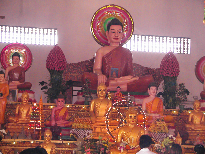
Covered galleries with columns define the boundaries of the first and second levels. The third level supports five towers –four in the corners and one in the middle and these is the most prominent architectural feature of Angkor Wat. This arrangement is sometimes called a quincunx. Graduated tiers, one rising above the other, give the towers a conical shape and, near the top, rows of lotuses taper to a point.

The overall profile imitates a lotus bud, Several architectural lines stand out in the profile of the monument. The eye is drawn left and right to the horizontal aspect of the levels and upward to the soaring height of the towers. The ingenious plan of Angkor Wat only allows a view of all five towers from certain angles. They are not visible, for example, from the entrance. Many of the structures and courtyards are in the shape of a cross. The. Visitor should study the plan on page 86 and become familiar with this dominant layout. A curved sloping roof on galleries, chambers and aisles is a hallmark of Angkor Wat. From a distance it looks like a series of long narrow ridges but close up from identifies itself. It is a roof made of gracefully arched stone rectangles placed end to end. Each row of tiles is capped with an end tile at right angles the ridge of the roof.
The scheme culminates in decorated tympanums with 
elaborate frames. Steps provide access to the various
levels. Helen Churchill Candee, who visited Angkor in the              Apsara Statue at Angkor Wat
 1920s, thought their usefulness surpassed theirarchitectural purpose.

The steps to Angkor Wat are made to force a halt at beauteous obstruction that the mind may be prepared for the atmosphere of sanctity, she wrote In order to become familiar with the composition of Angkor Wat the visitor should learn to recognize the repetitive elements in the architecture. Galleries with columns, towers, curved roofs, tympanums, steps and the cross-shaped plan occur again and again.

It was by combining two or more of these aspects that a sense of height was achieved. This arrangement was used to link one part of the monument to another. Roofs were frequently layered to add height, length or dimension. A smaller replica of the central towers was repeated at the limits of two prominent areas-the galleries and the entry pavilions. The long causeway at the entrance reappears on the other side of the entry pavilion.


SYMBOLISM

Angkor Wat is a miniature replica of the universe in stone and represents an earthly model of the cosmic world. The central tower rises from the center of the monument symbolizing the mythical mountain, Meru, situated at the center of the universe. Its five towers correspond to the peaks of Meru. The outer wall corresponds to the mountains at the edge of the world, and the surrounding moat the oceans beyond.

LAYOUT
Even though Angkor Wat is the most photographed Khmer monument, nothing approaches the actual experience of seeing this temple. Frank Vincent grasped this sensation over 100 years ago.

The general appearance of the wonder of the temple is beautiful and romantic as well as impressive and grand it must be seen to be understood and appreciated. One can never look upon the ensemble of the vat without a thrill, a pause, a feeling of being caught up onto the heavens. Perhaps it is the most impressive sight in the world of edifices.

Angkor Wat occupies a rectangular area of about 208 hectares (500 acres) defined by a laetrile wall. The first evidence of the site is a moat with a long sandstone causeway (length 250 meters, 820 feet; width 12 meters, 39 feet) crossing it and serving as the main access to the monument. The moat is 200 meters (656 feel) wide with a perimeter of 5.5 kilometers (3.4 miles).

The west entrance begins with steps leading to a raised sandstone terrace in the shape of a cross at the foot of the long causeway. Giant stone lions on each side of the terrace guard the monument. Looking straight ahead, one can see at the end of the causeway the entry gate with three towers of varying heights and with collapsed upper portion. This entry tower hides the full view of the five towers of the central group. A long covered failure with square columns and a curved roof extends along the moat to the left and right of the entry tower. This is the majestic facade of Angkor Wat and a fine example of classical Khmer architecture.

Helen Churchill candee must have been standing on this terrace almost 70 years ago when she wrote Any architect would thrill at the harmony of the fasade, an unbroken stretch of repeated pillars leading from the far angles of the structure to the central opening, which is dominated, by three imposing towers with broken summits. This facade originally had another row of pillars with a roof. Evidence of this remains in a series of round holes set in square based in front of the standing pillars.

Tip Before proceeding along the causeway turns right, go down the steps of the terrace and walk along the path a few meters for a view of all five towers of Angkor Wat. Return to the center of the terrace and walk down the causeway towards the main part of the temple. The left-hand side of the causeway has more original sand stone than the right-hand side, which was restored by the French.

In the 1920 when RJ Casey walked on this causeway he noted it was an oddity of engineering The slabs were cut in irregular shapes, which meant that each had to be chiseled to fit the one adjoining. The effect as seen under the noonday sun...is like that of a long strip of watered silk'10 On the left side just before the midway point in the causeway two large feet are carved in a block of sandstone. They belong to one of the figures at the entrances to Angkor Thom and were brought to Angkor Wat in this century the causeway was repaired with reused stones.

The upper portions of the three sections on this tower-one each at the center and the two ends – have collapsed. The porches on each end of the gallery may have served as passages for elephants, horses and carts as they are on ground level.

When Helen Churchill Candee saw these entrances in the 1920 she remarked that architecture made to fit the passage of elephants is an idea most inspiriting. A figure of a standing Visnu (eight arms) is in the right inside the entry tower. Traces of original color can be seen on the ceiling of the entry tower at the left. Continue westward along a second raised walkway (length 350 meters, 1,148 feet; width 9 meters, 30 feet).

A low balustrade resembling the body of a serpent borders each side. Short columns support the balustrade. Looking west one sees the celebrate view of Angkor Wat that appears on the Cambodian flag. Standing at this point one teels compelled to get to the wondrous group of the five domes, companions of the sky, sisters of the clouds, and determine whether or not one lives in a world of reality or in a fantastic dream. Six pairs of ceremonial stairs with platforms on each side of the walkway lead to the courtyard.

A continuation of the serpent balustrade along the walkway frames the stairs. This arrangement is sometimes called a landing platform. The balustrade terminates with the body of the serpent making a turn at right angles towards the sky and gracefully spreading its nine heads to from the shape of a fan. Two buildings, so-called libraries stand in the courtyard on the left and right, just past the middle of the causeway. These 'jewel-boxes Khmer art 'are perfectly formed.

A large central area, four porches, columns and steps present a symmetrical plan in the shape of a cross. Some of the columns have been replaced with cement copies for support. An original pillar lies on the ground before the library on the left. In front of the libraries are two basins (length 65 meters, 213 feet, width 50 meters, 164 feet) the one on the left is filled with water whereas the other lone is usually dry.

Tip Turn left at the first steps after the library and before the basin and follow the path for about 40 meters (131 feet) to a large tree for a superb view of the five towers of Angkor Wat, particularly at sunrise. The walkway leads to a terrace kin the shape of a cross, known as the Terrace of Honor, Just in front of the principal entry tower of Angkor Wat.

Supporting columns and horizontal carved molding around the base accentuate the form of the terrace. Steps flanked by lions on pedestals are on three sides of the terrace. Ritual dances were performed here and it may have been where the king viewed processions and received foreign dignitaries. R Casey sensed such activity in the 1920s One cannot but feel that only a few hours ago it was palpitating with life. The torches were burning about the altars.

Companies of priests were in the galleries chanting the rituals. Dancing girls were flitting up and down the steps... that was only an hour or two ago, monsieur....it cannot have been more.. From the top of the terrace there is a fine view of the gallery on the first level, known as the Gallery of Bas-reliefs (215 by 187 meters, 705 by 614 feet). The outer side, closest to the visitor, comprises a row of 60 columns whereas the inner side is a solid wall decorated with bas-reliefs.

Tip: At this point the visitor has the choice of continuing straight to the central towers or turning right to see the Gallery of Bas-reliefs (see pages 96-108 for a description of the bas-reliefs). The unit providing a link between the first and second levels is the Cross-shaped Galleries. This unique architectural design consists of two covered galleries with square columns in the shape of a cross and a courtyard divided into four equal parts with paved basins and steps. The method used by the Khmers to form corbel arches is visible in the vaults. Several decorative features in these galleries stand out windows with balusters turned as if they were made of wood, rosettes on the vaults, a frieze of Apsaras under the cornices, and ascetics at the base of the columns.

Tip: Some of the pillars in the galleries of this courtyard have inscriptions written in Sanskrit and Khmer. On either side of the courtyard there are two libraries of similar form but smaller than the ones along the entrance causeway The Gallery of 1,000 Buddha's, on the right, once contained many images dating from the period when Angkor Wat was Backlist. Only a few of these figures remain today. The gallery on the left is the Hall of Echoes, so named because of its unusual acoustics.

Tip: To hear the resonance in the Hall of Echoes walk to the end of the gallery, stand in the left-hand corner with your back to the wall, thump your chest and listen carefully. Those who want to visit the library should leave the door at the end of this gallery. There is a good view of the upper level of Angkor Wat from this library.

Return to the center of the cross-shaped galleries and continue walking toward the central towers. Another set of stairs alerts one to the continuing ascent. The outer wall of the gallery of the second level, closest to the visitor, (100 by 115 meters, 328 by 377 feet), is solid and undecorated, probably to create an environment for meditation by the priests and the king.

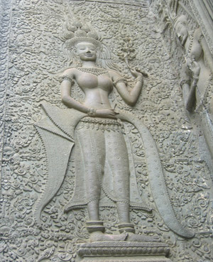
The starkness of the exterior of the second level gallery is offset by the decoration of the interior. Over 1,500 Apsaras (celestial dancers) line the walls of the gallery offering endless visual and spiritual enchantment. These graceful and beautiful females delight all visitors. They were crated by the Churning of the Ocean of Milk.

When one first walks into the courtyard the multitude of female figures on the walls and in the niches may seem repetitive but as one moves closer and looks carefully one sees that every one of these celestial nymphs is different, the elaborate coiffures, headdresses and jewellery befit, yet never overpower, these 'ethereal inhabitants of the heavens' Apsaras appear at Angkor Wat for the first time in twos and threes. These groups break with the traditional of decoration kin other part of the temple by standing with arms linked in coquettish postures and always in frontal view except for the feet, which appear in profile.

Pang, a Cambodian poet, in a tribute to the Khmer ideal of female beauty wrote of the Apsaras in the seventeenth century. These millions of gracious figures, filling you with such emotion that the eye is never wearied, the soul is renewed, and the heart sated! They were never carved by the hands of men! They were created by the gods living, lovely, breathing women! Only the king and the high priest were allowed on the upper or third level of Angkor Wat, it lacks the stately covered galleries of the other two but is the base of the five central towers, one of which contains the most sacred image of the temple.

The square base (60 meters, 197 feet long) of the upper level is 13 meters (43 feet) high and raises over 40 meters (131 feet) above the second level. Twelve sets of stairs with 40 steps each one in the center of each side and two at the corners-ascend at a 70-degree angle giving access to this level.

Tip: The stairway to the third level is less steep on the west (center) but those who suffer from vertigo should use the south stairway (center, which has concrete steps and a handrail. the steps on all sides are exceptionally narrow. the visitor should ascend and descend sideways. All the repetitive elements of the architectural composition of Angkor Wat appear on the upper level. The space is divided into a cross-shaped area defined with covered galleries and four paved courts. An entry tower with a porch and columns is at the top of each stairway. Passages supported on both sides with double rows of columns link the entry tower to the central structure. The corners of the upper level are dominated by the four towers. Steps both separate and link the different parts. A narrow covered gallery with a double row of pillars and windows and balusters on the outer side surrounds the third level. The Central sanctuary rises on a tiered base 42 meters (137 feet) above the upper level. The highest of the five towers, it is equal in height to the cathedral of Notre Dame in Paris. This central sanctuary sheltered the sacred image of the temple. It originally had four porches opening to the cardinal directions. The central core was walled up some time after the sacking of Angkor in the middle if the fifteenth century. Nearly 500 years later French archaeologists discovered a vertical shaft 27 meters (89 feet) below the surface in the center of the upper level with a hoard of gold objects at the base. At the summit the layout of Angkor Wat reveals itself at last. The view is a spectacle of beauty befitting the Khmer's architectural genius for creating harmonious proportions.

Tip: Walk all the way around the outer gallery of the upper level to enjoy the view of the surrounding countryside, the causeway in the west and the central group of towers. You have not quite an aerial view the Phnom is not high enough for that ...But you can see enough to realize something of the superb audacity of the architects who dared to embark upon a single plan measuring nearly a mile square. Your point of view is diagonal, across the north-west corner of the moat to the soaring lotus-tip of the central sanctuary, you can trace the perfect balance of every faultless line, Worshipful for its beauty bewildering in its stupendous size, there is no other point from which the Wat appears so inconceivable an undertaking to have been attempted-much less achieved by human brains and hands.

GALLERY OF BAS-RELIEF
By their beauty they first attract, by their strangeness they hold attention, Helen Churchill Candee wrote of the bas-reliefs in the 1920 .The Gallery of Bas-reliefs, surrounding the first level of Angkor Wat, contains 1,200 square meters (12,917 square feet) of sandstone carvings. The relief covers most of the inner wall of all four sides of the gallery and extend for two meters (seven feet) from top to bottom.

The detail, quality composition and execution give them an unequalled status in world art. Columns along the outer wall of the gallery create an intriguing interplay of light and shadow on the relief. The effect is one of textured wallpaper that looks like the work of painters rather than sculptors' The bas-reliefs are of dazzling rich decoration-always kept in check, never allowed to run unbridled over wall and ceiling possess strength and repose, imagination and power of fantasy, wherever one looks [the] main effect is one of "supreme dignity "wrote a visitor 50 years ago.

The bas-reliefs are divided into eight sections, two on each wall of the square gallery each section depicts a specific theme. In addition the two pavilions at the corners of the west Gallery have a variety of scenes. The book does not include description of badly damaged relief.

Some others are unidentifiable .The composition of the relief can be divided into two types scenes without any attempt to contain or separate the contents and scenes contain or separate the contents; and scenes contained in panels which are some-times superimposed on one another-this type is probably later. The panels run horizontally along the wall and generally consist of two or three parts. Sometimes the borders at the top bottom are also decorated. Themes for the bas-reliefs derive from two main sources-Indian epics and sacred books and warfare of the Angkor Period. Some scholars suggest that the placement of a relief has a relevance to its theme. The relief on the east and west walls, for example, depict themes related to the rising and setting sun. The word bas means low or shallow and refers to the degree of projection of the relief. The method of creating relief at Angkor Wat was generally to carve away the background leaving the design in relief. Sometime, though the method was reversed giving a sunken appearance. of some of the relief have a polished appearance on the surface.
There are two theories as to why this occurred. The position of the sheen and its occurrence in important parts of the relief suggest it may have resulted from visitors rubbing their hands over them. Some art historians, though think it was the result of lacquer applied over the relief. Traces of gilt and paint, particularly black and red, can also be found on some of the relief's. They are probably the remains of an undercoat or a fixative. Several primitive artistic conventions are seen in the bas-reliefs. A river is represented by two parallel vertical lines with fish swimming between them. As in Egyptian art, a person's rank is indicated by size. The higher the rank the larger the size. In battle scenes, broken shafts on the ceremonial umbrellas of a chief signify defeat. Perspective is shown by planes placed one above the other. The higher up the wall, the further away is the scene. Figures with legs far apart and knees flexed are in a flying posture.

INVITING THE GALLERY OF BAS-RELIEFS
Those who like to linger in this wonderful gallery of bas-reliefs will always be made happy by new discoveries will return as other joys of Angkor will allow.
Tip: As the bas-reliefs at Angkor Wat were designed for viewing from to lefts the visitor should, follow this convention for maximum appreciation. Enter at the west entrance, turn right into the gallery and continue walking counterclockwise. If you start from another point always keep the monument on your left. If one's time at Angkor is limited, the following bas-recommended.

LOCATION THEME
Description of the bas-reliefs in this guidebook follows the normal route for viewing Angkor Wat. They begin in the middle of the West Gallery and continue counter clockwise. The other half of the West Gallery is at the end of the section. Identifying characteristics are in parenthesis and the locations of scenes on the bas-reliefs are in bold type.

WEST GALLERY - BATTLE OF KURUKSHETRA
This battle scene is the main subject of the Hindu epic Mahabharata. It recalls the historic was wars in Kurukshetra, a province in India, and depicts the last battle between rival enemies who are cousins (see page 54 for a description of this legend). The armies of the Kauravas and the Pandavas march from opposite ends towards the center of the panel where they meet in combat. Headpieces differentiate the warriors of the two armies. The scene begins with infantry marching into battle and musicians playing a rhythmic cadence. The battlefield is the scene of hand-to-hand combat and many dead soldiers.

Chief officers and generals (represented on a larger scale) oversee the battle in chariots and on elephants and horses. The scene builds up gradually and climaxes in a melée. Bisma (near the beginning of the pane), one of the heroes of the Mahabharata and commander of the Kauravas, pierced with arrow, is dying and his men surround him. Arjuna (holding a shield decorated with the face of the demon rahu) shoots an arrow at Krsna, his half-brother, and kills him. After death, Krisna (four arms) becomes the charioteer of Arjuna.

Corner pavilion (southwest)

Enter the pavilion and view the scenes facing you. Then continue clockwise around the pavilion. The bas-reliefs in this pavilion depict scenes from epic the Ramayana.

EAST

A- Left, Water festival; two ships (superimposed) with Apsaras, chess players (top ship)
B- Center, above the door: A god receiving offerings.

SOUTH
C- Left, top to bottom. A fight between Vali and Sugriva, the monkey king; Rama shoots Vali with an arrow who lies in the arms of his wife (three pointed headdress); monkeys mourn his death 
D- Center, above the door: Murder of a demon; Krsna extinguishes a fire west. 
E- Left: Siva sits with his wife Paravati on Mount Kailasa 
F- Center, above the door: Krisna uproots trees with a stone he is tied to. 
G- Right: Ravana, disguised as a chameleon, presents himself at the palace of Indra.

NORTH
H- Left: The Churning of the Ocean of Milk. 
I - Center, above the door: Rama kills Marica, who, disguised as a golden stag, helped in the abduction of Sita. 
J- Right: Krisna lifts Mount Govardhana to shelter their shepherds and their herds from the storm ignited by the anger of Indra.

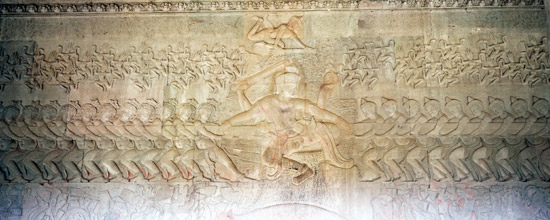
SOUTH (HISTORICAL) GALLERY - ARMY OF KING SORYAVAMAN II
This gallery depicts a splendid triumphal procession from a battle between the Khmers and their enemies. The relief's show methods used in warfare, mainly hand-to-hand combat, as they no machinery and no knowledge of firearms.

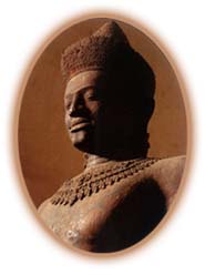
The naturalistic depiction of trees and animals in the background of this panel is unusual. The central figure of this gallery is King Suryavarman II, the builder of Angkor Wat, who appears twice. An inscription on the panel identifies him by his posthumous name, suggesting it may have been done after his death. The rectangular holes randomly cut n this gallery may have contained precious objects of the temple. On the upper tier the king (seated with traces of gilt on his body) holds an audience on a mountain. Below of the place walk down a mountain in the forest.

The army gathers for inspection and the commander mounted on elephants join their troops who are marching towards the enemy. The commander's rank is identified by a small inscription near the figure. King Suryavarman II stands on an elephant (conical headdress, sword with the blade across his shoulder) and servants around him hold 15 ceremonial umbrellas. Visnu stands on a Garuda on a Garuda on a flagpole in front of the king's elephant. The lively and loud procession of the Sacred Fire (carried in an ark) follows with standard bearers, musicians and jesters. Brahmans chant to the accompaniment of cymbals. The royal sacrifice in a palanquin.

Towards the end of the panel: The military procession resumes with a troop of Thai soldiers (pleated skirts with floral pattern; belts with long pendants; plaited hair; headdresses with plumes; short moustaches) led by their commander who is mounted on an elephant. The Thai troops were probably either mercenaries of a contingent from the province of Louvo (today called Lopburi) conscripted to the Khmer army. A number of the Khmer warriors wear helmets with horns of animal heads (deer, horse, bird) and some of their shields are embellished with monsters for the same purpose.

JUDGMENT BY YAMA; HEAVEN AND HELL
Three tiers recount the judgment of mankind by Yama and two tiers depict Heaven and Hell. Inscriptions have identified 37 heavens where one sees leisurely pursuits in palaces and 32 hells with scenes of punishment and suffering. Draperies and Apsaras separate the two and a row of Garudas borders the tier in the bottom. The roof was destroyed by lightning in 1947 and subsequently the ceiling of this gallery was restored by the French. Traces of gilt can be on riders on horses at the beginning of the panel. The lower section of the panel was badly damaged and liter filled with cement.

Lower tier: Yama, the Supreme Judge (multiple arms, wields a staff and rides a buffalo), points out to his scribes the upper road representing heaven and the lower one of hell. Departed spirits a wait judgment. Assistants to Yama shove the wicked through a trap door to the lower regions where torturers deliver punishments such as sawing a body in half for those who overeat. Lawbreakers have their bones broken. Some of the punished wear iron shackles or have nails pierced through their heads. Upper tier: A celestial palace is supported by a frieze of Garudas with Apsaras in the skies.

EAST GALLERY - CHURNING OF THE OCEAN OF MILK
This is the most famous panel of bas-reliefs at Angkor Wat and derives from the Indian epic Bagavata-Pourana. The Ocean of Milk is churned by gods and demons to generate Amrta, the elixir of life. the purpose of the churning is to recover lost treasures such as the sourer of immortality, Laksmi the goddess of good fortune, the milk white elephant of Indra, and the nymph of loveliness. The retrieval of these objects symbolizes prosperity. It takes place during the second ascent of Visnu, when he is incarnated as a tortoise.

The scene is decided into three tiers. The lower tier comprises various aquatic animals, real and mythical, and is bordered by a serpent. The middle tier has, on one side, a row of 92 demons (round bulging eyes, crested helmets) and, on the other side, a row of 88 gods (almond-shaped eyes, conical headdresses). They work together by holding and churning the serpent. Hanuman, the monkey god, assists. Visnu, in his reincarnation as a tortoise, offers the back of his shell as a base for the mountain Mandara, and as a pivot for the churning. He sits on the bottom of the Ocean. A huge cord in the form of the body of the serpent Vasuki acts as a stirring instrument to churn the sea.

To begin the motion the gods and demons twist the serpent's body; the demons hold the head and the gods hold the tail of the serpent. Then by pulling it rhythmically back and for th they cause the pivot to rotate and churn the water.

The gods and demons are directed by three persons (identified by their larger size). Indra is on top of Visnu. On the extreme right Hanuman, ally of the gods, tickles the serpent. Upper tier: During the churning various female spirits emerge. Visnu appears in this scene again in yet another reincarnation-as a human being-to preside over the "churning "which, according to legend, lasted more than 1,000 years.

Numerous other beings are depicted such as the three-headed elephant mount of Indra, Apsaras and Laksmmi, the goddess of beauty. They churning provoke the serpent to vomit the mortal venom, which covers the waves. Afraid the venom may destroy the gods and demons, Brahma intervenes and requests Siva to devour and drink the venom, which will leave an indelible trace on Siva's throat. He complies and, as a result, he Amtrak pours forth. The demon rush to capture all the liquid. Visnu hurries to the rescue and assumes yet another reincarnation in the form of Maya, a bewitching beauty, and is able to restore much of the coveted liquid.

Churning of the Ocean of Milk Bas Relief

INSCRIPTION 
Just past the middle of the East Gallery there is an interesting inscription of the early eighteenth century when Angkor Wat was a Buddhist monastery. It tells of a provincial governor who built a small tomb where he deposited the bones of his wife and children. The structure is in poor condition but recognizable in its original location, directly in front of the inscription in the gallery.

VICTORY OF VISNU OVER THE DEMONS 
The bas-reliefs in this section of the Wast Gallery and the south part of the North Gallery were probably completed at a later date, perhaps the fifteenth or sixteenth century. The stiffness of the figures and the cursory workmanship reveal this change. An army of demons marches towards the center of the panel. Center: Visnu (four arms) sits on the shoulders of a Garuda.

A scene of carnage follows. Visnu slaughters the enemies on both sides and disperses the bodies. The leaders of the demons (mounted on animals or riding or riding in chariots drawn by monsters) are surrounded by marching soldiers. Another group of warriors (bows and arrows) with their chiefs (in chariest of mounted on huge peacocks) follows.

NORTH GALLERY VICTORY OF KRISNA OVER BANA THE DEMON KING
At the beginning of the panel Visnu in his incarnation as Krsna (framed by two heroes) sits on the shoulders of a Gruda. Agni, the god of Fire (multiple arms), sits on a rhinoceros behind him. This scene appears several times. A wall surrounding the city is on fire and prevents the advance of Krsna (mounted of a Garuda) and his army of gods. This Krsna scene also appears several times in the panel. The Garuda extinguishes the fire with water from the sacred river Ganges. The demon Bana (multiple arms, mounted on a rhinoceros) approaches from the opposite direction. Extreme right: Krsna (1,000 heads, hands across his chest) kneels in front of Siva who sits enthroned on Mount Kailasa with his wife Parvati and their son ganesa (head of an elephant) as they demand that Siva spare the life of Bana.

BATTLE BETWEEN THE GODS AND THE DEMONS 
A procession of 21 gods of the Brahmanic pantheon march in procession carrying classic attributes and riding traditional mounts. One-god battles against a demon while warriors on both sides battle in the background. A series of adversaries follow, the Kubera, God of riches (with bow and arrow), Appears on the shoulders of a Yaksa; followed by Skanda, Goe of war (multiple heads and arms), mounded on a peacock; Indra stands on his mount the elephant; Visnu (four arms) sits on his mount, a Guard; a demon (tiered heads) shaking swords; Yama, God of Death and. Justice (sword and shield), stands in a chariot pulled by horses; and Varian, God of the Water, stands on a five-headed serpent harnessed like a beast of burden.

CORNER PAVILION (NORTHWEST)
Enter the pavilion and walk counter-clockwise. Several of the scenes are in good condition.

NORTH
A- Right: The women's quarters of a palace. 
B- Center, above the door: An attempt to abduct site in the forest. 
C- Left, badly damaged: A scene from the Ramayana. 
Above: Tiers of monkeys and a pyre

WEST
D- Right: rama in his chariot (drawn by geese) returns victorious to Ayodhya 
E- Center, above the door: Rama and Laksmana surrounded by monkeys. 
F- Left: A conversation between Sita and Hanuman in the forest; Hanuman gives Rama’s ring to Sota.

SOUTH
G- Right Visni (seated, four arms) surrounded by Apsaras. 
H- Center, above the door: Rama and Laksmana battle a monster (headless, face on stomach) 
I- Left: Rama wins an archery competition; Rama and Sita sitting together.

EAST
J- Right: Visnu (four arms) on a Garuda; Krsna (mounted on a Garuda) bring back Mount Maniparvata which he took from a demon he killed; his army carries the remains of the demon. 
K- Center, above the door: Discussions on an alliance. 
Left: Rama and his brother Laksmana.
Right: Suryva, the monkey king L- Left: Visnu reclines on the serpent Anent.

Below: A group of nine gods with their mounts 
(1) Surya in a chariot pulled by horses 
(2) Kubera standing on the shoulders of a Yaksa 
(3) Brahma riding a goose 
(4) Skanda on a peacock 
(5) An unidentified god on a horse 
(6) Indra on a three-headed elephant 
(7) Yama riding a buffalo 
(8)Siva on a bull 
(9) An unidentified god on a lion

WEST GALLERY - BATTLE OF LANKA
This scene from the Ramayana is a long and fierce struggle between Rama and the demon king Ravana (10 heads and 20 arms), near the center. It is among the finest of the bas-reliefs at Angkor Wat. The battle takes place in Lanka (Sri Lanka) and ends with the defeat of Ravana, captor of Sita, the beautiful wife of Rama. The central figures are the monkey warriors who fight against the raksasas on Rama's side.

The brutality of war is juxtaposed with a graceful rendition of lithesome monkeys. Past the center: Rama stands on the shoulders of Sugriva surrounded by arrows; Laksmana, his brother, and an old demon, stand by Rama. Nearby, the demon king Ravana (10 heads and 20 arms) rides in a chariot drawn by mythical lions.

Further on, Nala, the monkey who built Rama's bridge to Lanka, is between them leaning on the heads of two lions. He throws the body of one he has just beaten over his shoulder. A monkey prince tears out the tusk of an elephant, which is capped with a three-pointed headdress and throws him and the demon to the ground.

Banteay Srei Temple

$
0
0

Banteay Srei Temple
Banteay Srei temple was built by a Brahmin Yajnavaraha with his younger brother in 967AD in the middle of 10th century. While at that period, king Jayavarman V was still very young about 15 years old, when his father king Rajendravarman II had died. Thus, all administrative affairs and religious practices include to build temples was under organized by his guru Brahmin Yajnavaraha. BrahminYajnavaraha was also a royal blood who was a grandson of king Hurshavarman I.
Banteay Srei was a new name which meaning in Khmer is "Citadel of Woman".Butaccording to inscription on the door piers of its structure tells us that the original name of this temple was Isvarapura which meaning in  Cambodian is the city of Shiva.Thus, from its origin name we can tell that Banteay Srei was a Hindu temple and dedicate to Shiva.

Banteay Srei is just only temple in the Angkor period  that built of pink and yellow sandstone. The pink and yellow sandstone are high quality material more than the gray and green sandstone that used to build Angkor Wat and Bayon so on. As pink and yellow sandstone are so hard, that is why the carving of Banteay Srei are still good condition and very exquisite.

The Temple wares discovered by French in 1914 , but the site wasn't cleared until 1924 . the theft of the several important pieces of sculptures and lintels by a European expedition , meticulously planned by the young Frenchman , Malraux , caused a great scandal in 1923 , but hastened the archaeological work . The thieves were held under house arrest in Phnom Penh and only released after the return of the stolen pieces .

Then in 1924, ten years after they knew its location, Mr Henri Marchal a French architect in the Angkor Conservation Department was sent to study a method of anastylosis with Dutch in Borobudur temple of Indonesia. Because at that time Dutch restored Borobudur temple in a system of anastylosis.

Anastylosisis Greecewords that mean, "When a pillar had fallen down, they have to raise it spillar back to its origin spot". It is also meaning that the anastylosis system is avoid to use the new material and avoid to carve the same detailsfrom its origin as well.

Mr.Henri Marchal was getting a great success for his job of restoration Banteay Srei temple for about 10 years. We noticed that when they saw Banteay Srei before restoration it completely collapsed and shrouded by jangle. Saying that Mr. Henri Marchal faced a difficult security problem with Khmer Isarak who struggled in gorilla war fought against French colonial during his teams worked in Banteay Srei. That is why some part of this temple is never done. But now the Swiss teams will continue the restoration from French.

First Entrance:
This entrance structure decorated with Indra God of Rain and King of Paradise riding on three headed elephant’s name Aravata.

Belowis Kala face figure. Kala was a monster guardian over the temple doorway . Atthe edge of the pediment there are Nagas coming out from the mouth of Makara.Makara is a Hindu mythical sea creature combined with sneak body, lion head and sometimes with elephant trunk. At the door frames of the first entrance structure there are octagonal balusters with its very beautiful details.Octagonal is significant of the eight direction of the universe.

This entrance structure originally had used woods to build the roof, due to theearlier period of Angkor in the 9th to 10th century; the Khmer monumental temples alwaysused the timber for its roof construction, instead of using sandstone.

Causeway:
Khmer monumental temples share very similar layout and plans. For example, at first,you will have an entrance, then you will see a causeway leading to temple, andthe moat surrounding so on. However, of course, their architectural templestyles are completely different. The first causeway of Banteay Srei hasmeasured of 67m long and flanking with 34 sandstone lanterns on each side. This causeway paved by laterite. Lanterns are symbolic of flame.

Along this causeway, therewere two halls, one on the each side. Originally, these halls were using as are sting area for the pilgrims.

At the first causeway,there are several constructions with empty roof. But their pediments, theirbalusters, and their lintels so on are still excellent shape with veryexquisite carving into the pink sandstone. According to inscriptions, thosestructures served as resting halls and to install the sacred Hindu statues as well.

Northern Resting House

When we walk in for a halfof causeway if we turn to the north this building was serving as a place forpilgrims taking a rest its pink sandstone pediment has excellent carving, whichdepicting Narashimha is tearing chest of Hiranyakashipu. Narashimha is half manand half lion. He was a number four of Vishnu incarnations who came to convincethe Demon king Hiranyakashipu in order to retrieve the three worlds from thistyrant ruler.

Southern Resting House

To the south of midwayfrom the causeway, there are three resting houses. The middle is the biggest othertwo which are poor condition, but the one in the middle has excellent pediment.This pediment is depicting Shiva riding on his Bull with his wife Pavati.

Betweenthe first entrance to the second entrance, there are several more pediments onthe ground, Among of those pediments are lying on the ground, there is one onthe north has very interesting story which depicting a chapter of Ramayana,where king of Lanka Ravana adducted Sita, and we also see two brothers (Ramaand Laksmana) appearing near golden deer. 

Second Entrance:

Thefirst causeway measured of 67m long ended at the second Gopura. At the doorframes of the second entrance, there areinscriptions written by the builder Brahmin Yajnavaraha. The inscriptions tell us the date of the temple, tellus the king and his religion foundation, tell us the ritual ceremonies with thesandal woods to the Fire God and also tell us Destroyer God Shiva and hisconsorts who represented to a Linga and Yoni so on

Enclosure wall:

Atthe second entrance, there is a laterite wall, this wall measures of 90m X 110m, and the same as a moat surrounding the wall as well. Move onthe mouth of this moat from the Gopura a bit to south, there are several lintels and pediments lying on theground. Among of those motifs there is a lintel which depicting Brahma riding on a Sacred Goose andaccompany with two lions.

Second Causeway:

Thereis a short causeway crossing the moat and leading to the third Gopura. To havetwo causeways in the Khmer temple complex are the significant the rainbowbridges of connection from underworld to the world (first causeway) and from the world to heavens (second causeway).

Third Gopura:

This entry tower has a unique character, because the decoration motifs in thisGopura is quite different from any temples that we have seen. They designedwith the double door gateways, an addition there are so beautiful spiral at the edge of the pediments and the spire of the entrance designed with extraordinary diamond motifs and the fire flame stay on top. But the motif of the fire flame which to serve as the entrance’s spire had stolen just in 1993, otherwise it would be the same as the one on the second one. On the lintel depicting Laksmei Goddess of Beauty and Good  Fortune , She is blessing by two white elephants before married to Lord Vishnu.

Atthe third Gopura, there is also another enclosing laterite wall. This wall measured of 38m X 42m. When we enter to this Gopura, then we have a rectangular pedestal in the middle of the room.This pedestal there are two holes it might for holding the statues of God and Goddess Shiva and Uma

Fourth Gopura:

Atthe pediment of the fourth Gopura and just at the front of Bull Nandi, there isa unique detail carving depicting Shiva he Generated in the action of performance a dance.

The fourth Gopura, there is another wall built of brick. So far, this brick wall ismuch ruined, it's more than 2m high. This enclosing wall has ameasure of 24m X 24m to separate from the public compound (third wall)to the VIP compound. Originally, the public would not enter to the central shrine at all. The central tower was a compound of the royal family and high priests to go in.

In side this square compound, there are two library buildings. Library buildings built of late rite mixing with pink sandstone. Its real doors are facing to the west. Libraries of the Khmer temples  must appear in pair one the north and another one on the south. It was the place to keep the holy text books and the place to pray to the Fire God as well.

Southern Library :

The  southern library depicting a Hindu myth of Ravana king of demons Shaking Mt. Kalasa home of Shiva , While Shiva and his wife were having the meditation .

The west pediment of southern library got carving details depicting the story of Kamashutra God of Love Shooting Arrow of Love to Lord Shiva .

Northern Library:

The east pediment of northern library got a great reliefs depicting one of the chapters of Mahabaratta where Indra and Agni got a challenge.

The west pediment of north library got the relief depicting a chapter of Mahabaratta where Krisna the hero of the story came to kill his uncle king Kamsa, in order to revenge him to his parents. By the way, Krisnais provoking to remove all tyrants from Kurushatra region.

The Central Towers:

The central towers of Banteay Srei designed with three temple shrine and all the three standing on a single platform. The three temple shrines are represented to the Trinity of Hindu. The one located in the middle dedicating to Lord Shiva, The northern shine was dedicated to Lord Vishnu, The southern tower shrine was dedicated to Lord Brahma .

Asthe typical smaller shrine of the Khmer temple, the holy shrines of Banteay Srei got only one real door on the east, while three other doors designed with the blind ones. We believed that in each shrine originally used to install the statues of the Trinity, but now nothing remain.

West Entrance:

The relief on the pediment depicted a chapter of Ramayana where two monkeys who are brother being struggled, then Rama and Laksmana took an intervention to shoot older monkey under the name of Valin, in order to help a younger monkey Sokriva. When Sokriva proclaimed as a king of monkey, then he could send his monkey troops to help Rama to flight against Ravana in Lanka for his wife Sita .


Quoted from:  www.tourismcambodia.com
                        www.asisbiz.com

Banteay Kdei Temple

$
0
0

Banteay Kdei (Prasat Banteay Kdei) Is a temple at Angkor, Cambodia. 
Built in the late 12th to early 13th centuries CE during the reign of Jayavarman VII, it is a Buddhist temple in the Bayon style, similar in plan to Ta Prohm and Preah Khan, but less complex and smaller. Its structures are contained within two successive enclosure walls, and consist of two concentric galleries from which emerge towers, preceded to the east by a cloister. Banteay Kdei has been occupied by monks at various intervals over the centuries, but the inscription stone has never been discovered so it is unknown to whom the temple is dedicated. There is no record of why it was built-or by whom-because no marker stone with that information has ever been found. Its name means 'The citadel of the monks' cells', but that does not necessarily indicate its function.
What is known is that Banteay Kdei grew by amalgamation from a small site to a large central temple with its own enclosure wall that protected a large city.The citadel of the cells. In the ruin and confusion of Banteay Kdei the carvings take one's interest. They are piquant, exquisite, not too frequent... they seem meant.. to make adorable a human habitation. Banteay Kdei is located south of Ta Prohm. A enter the monument from the west and leave at the west or vice versa, either way, also visit Srah Srang. It was built in middle of the 12th century to the beginning of the 13th century by king Jayavarman II in Mahaya Buddhism with following at least two different art periods Angkor Wat and Bayon are discernible at Banteay Kdei.

BACKGROUND
Banteay Kdei has not been restored and allows the visitor to experience what it may have looked like originally. Changes and additions account for is unbalanced layout. Banteay Kdei was built of soft sandstone and many of the galleries and porches have collapsed. The wall enclosing the temple was built of reused stones.

LAYOUT
The temple is built on the ground level use as a Buddhist monastery. The elements of the original design of Banteay Kdei seem to have been a Central Sanctuary, a surrounding gallery and a passageway connected to another gallery. A moat enclosed the original features of the temple. Another enclosure and two libraries were among the additions in the Bayon period. The outer enclosure (700 by 500 meters 2,297 by 1,640feet) is made of laterite and has four entry towers.

A rectangular courtyard to the east is known as 'the hall of the dancing girls', a name derived from the decoration which includes dancers. The entry tower of the second enclosure (3) is in the shape of a cross with three passages; the two on either end are connected to the literate wall of the enclosure (4) 320 by 200 scrolls of figures and large female divinities in niches. In the interior court there is a frieze of Buddha.

A causeway of a later date, bordered with serpents, leads to the entry tower of the third enclosure. It comprises a laetrile wall includes a gallery with a double row of sandstone pillars that open onto a courtyard. Tip Parts of this area have been walled in and passage is limited. Vestiges of the wooden ceiling can still be seen in the central Sanctuary. The galleries and halls, which join it in a cross to the four entry towers, are probably additions. Two libraries open to the west in the courtyards on the left and right of the causeway.


     Quoted from:  www.asisbiz.com
                              www.tourismcambodia.com

Baksei Chamkrong Temple

$
0
0

Baksei Chamkrong Temple (Prasat Baksei Chamkrong)
The bird that shelters under its wings.This little temple with its four square tiers of laterite, crowned by a brick sanctuary, might serve for a model in miniature of some of its giant neighbors, and is almost as perfect as perfect as the day it was built.
Prasat Baksei Chamkrong is located 150 meters (492 feel) north of Phnom Bakheng and 80 meters (262 feet) from the road leading to the south gate of Angkor Thom. A visit to Baksei Chamkrong can be combined with a stop at the south gate of Angkor Thom. Enter and leave the temple from the east entrance.

Tip: The stairs to the Central Sanctuary are in poor condition but the architecture and decoration of this temple can be viewed by walking around it (in a clockwise direction). Those who persist in climbing to the Central Sanctuary should use the north stairway. It was built in middle of the tenth century (947), perhaps begun by Harshavarman I and completed by Rajendravarman II, dedicated to Siva (Hindu) may have been a funerary temple for the parents of the king with following transitional between Bakheng and Koh ker.


BACKGROUND
According to legend, the king fled during an attack on Angkor and was saved from being caught by the enemy when a large bird swooped down and spread its wings to shelter the king. The name of the temple derives from this legend. Baksei Chamkrong was the first temple-mountain at Angkor built entirely of durable materials brick, laterite and sandstone. Even though it is small the balanced proportions and scale of this monument are noteworthy. Inscriptions on the columns of the door and the arches give the date of the temple and mention a golden image of Siva.

LAYOUT
Baksei Chamkrong is a simple plan with a single tower on top of a square tiered base with four levels of diminishing size (27 meters, 89 feet, a side at the base) built of laterite (1-4). The height from the ground to the top of the Central Sanctuary is 13 meters (43 feet). Three levels of the base are undecorated but the top one has horizontal molding around it and serves as a base for the Central sanctuary. A steep staircase on each side of the base leads to the top. A brick wall (5) with an entry tower (6) and sandstone steps enclosed the temple. Although it has almost all disappeared vestiges are visible on the east side of the temple.


CENTRAL SANCTUARY 

The square central tower is built of brick and stands on a sandstone base. It has one door opening to the east with three false doors on the other sides. As is typical of tenth-century Khmer architecture, the columns and lintels are made of sandstone. A vertical panel in the center of each false door contains motifs of foliage on stems. The interior of the tower has a sunken floor and a vault with a corbel arch. The finely worked decoction on the sandstone columns and horizontal beams above the doors imitates woodcarving. An outline divinity can be seen in the bricks at the corners of the tower. A three-headed elephant on the east lintel is finely carved.


Quoted from: www.asisbiz.com
                        www.tourismcambodia.com

Baphuon Temple

$
0
0
Baphoun Temple (Prasat Baphuon)
The Baphuon is a temple at Angkor, Cambodia. Built in the mid-11th century, it is a three-tiered temple mountain built as the state temple of Udayadityavarman II dedicated to the Hindu God Shiva. The temple adjoins the southern enclosure of the royal palace and measures 120 metres east-west by 100 metres north-south at its base and stands 34 meters tall without its tower, which would have made it roughly 50 meters tall. Its appearance apparently impressed Emperor Chengzong of Yuan China's late 13th century envoy Chou Ta-Kuan during his visit from 1296 to 1297, who said it was 'the Tower of Bronze...a truly astonishing spectacle, with more than ten chambers at its base. In the late 15th century, the Baphuon was converted to a Buddhist temple. A 9 meter tall by 70 meter long statue of a reclining Buddha was built on the west side's second level, which probably required the demolition of the 8 meter tower above explaining its current absence. The temple was built on land filled with sand, and due to its immense size the site was unstable throughout its history. By the 20th century, much of the temple had largely collapsed, and restoration efforts have since proven problematic: a first effort begun in 1960 was interrupted by the coming to power of the Khmer Rouge, and records of the positions of the stones were lost.
Phimeanakas, Prasat Phimean Akas, 'celestial temple') or Vimeanakas, Prasat Vimean Akas) atAngkor, Cambodia, is a Hindu temple in the Khleang style, built at the end of the 10th century, during the reign of Rajendravarman (from 941-968), then rebuilt by Suryavarman II in the shape of a three tier pyramid as a Hindu temple. According to legend, the king spent the first watch of every night with a Naga girl in the tower, during that time, not even the queen was permitted to intrude. Only in the second watch the king returned to his palace with the queen. If the naga who was the supreme land owner of Khmer land did not show up for a night, the king's day's would be numbered, if the king did not show up, calamity would strike his land. North of the Golden Tower [Bayon], rises the Tower of Branze [Baphuon] higher even than the Golden Tower : a truly astonishing spectacle, with more than ten chambers at its base. Prasat Baphuon is located 200 metres (656 feet) northwest of the Bayon and south of Phimeanakas. An enter and leave at the east.

Tip: Access to the summit is difficult as much of the temple has collapsed and it is overgrown but for those stalwarts who want to go to the top, use the way with columns at the east and the temple of Phimeanakas on the left. Visitors should walk down the causeway, climb the steps to the first tier, turn left and walk around the temple, always keeping it on their right. It was built in middle of the 11th century (1060) by king Udayadityavarman II, dedicated to Siva (Hindu) with following Prasat Baphuon.

BACKGROUND
The grandeur of Baphuon as described above by Zhou Daguan is unrecognizable today because of the poor condition of the temple. The French were in the process of restoring this temple when they were forced leave Angkor in 1972 because of war. Baphuon is situated inside the royal city of Angkor Thom but dates from the eleventh century and was built before the city was established. An interesting feature of Baphuon are the bas-reliefs which are scenes carved in small squares. Unfortunately few of these are visible because of the poor state of the temple. The narrative themes are realistic depictions of daily life and forest scenes.

LAYOUT
Baphuon is a single sanctuary temple-mountain situated on a high base. It is a symbolical representation of Mount Meru. A rectangular sandstone wall measuring 425 by 125 metres (1394 by 410 feet) encloses the temple. A long sandstone elevated approach (200 metres, 656 feet) at the east entrance forms a bridge to the main temple. It is supported by three rows of short columns.

Tip: Before walking down the approach turn left at the east entry tower and walk to the end of the gallery for a superb view of a four-faced tower of the Bayuon framed by a doorway of Baphuon. The approach is intercepted by a pavilion in the shape of a cross (4) with terraces on the left and right sides. Turn left and walk to the opening the approach. Continue to the view of the arrangement of the imposing pillars under the approach. Continue to the end of the gallery to see a rectangular paved pool. The temple stands on a rectangular sandstone base with five levels that are approximately the same size, rather than the more common form of successively smaller levels. The first, second and third levels are surrounded by sandstone galleries. Baphuon is the first structure in which stone galleries with a central tower appear. Two libraries (6) in the shape of a cross with four porches stand in the courtyard. They were originally connected by an elevated walkway supported by columns. The gallery of the enclosure collapsed and, at a later date , the stones from it were modeled into the shape of a reclining Buddha that spans the length of the west wall ( the head is on the left, facing the temple) . It is an abstract form and the outline of this Buddha is difficult to distinguish. A stairway leading to the summit begins in the middle of the Buddha. The top level is in poor condition due to several collapses. Originally there was a Central Sanctuary with two wings. Each side of the entrance to the Central Sanctuary is carved with fine animated figures. If you look carefully you can see these from the ground on the west side.

Tip: The view from the top with Phnom Bakheng in the south and Phimeanakas in the north is magnificent.


Quoted from: www.asisbiz.com
                       www.tourismcambodia.com

Viewing all 104 articles
Browse latest View live